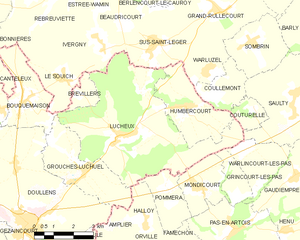
Le Souich (Le Souich)

- commune in Pas-de-Calais, France
- Country:

- Postal Code: 62810
- Coordinates: 50° 13' 22" N, 2° 22' 1" E


- GPS tracks (wikiloc): [Link]
- Area: 5.11 sq km
- Population: 156
- Wikipedia en: wiki(en)
- Wikipedia: wiki(fr)
- Wikidata storage: Wikidata: Q875719
- Wikipedia Commons Category: [Link]
- Freebase ID: [/m/02z9b3g]
- GeoNames ID: Alt: [6618314]
- SIREN number: [216208025]
- BnF ID: [15269243f]
- INSEE municipality code: 62802
Shares border with regions:


Ivergny
- commune in Pas-de-Calais, France
- Country:
- Postal Code: 62810
- Coordinates: 50° 14' 20" N, 2° 23' 33" E
- GPS tracks (wikiloc): [Link]
- Area: 7.34 sq km
- Population: 261

Lucheux
- commune in Somme, France
- Country:
- Postal Code: 80600
- Coordinates: 50° 11' 48" N, 2° 24' 37" E
- GPS tracks (wikiloc): [Link]
- Area: 27.65 sq km
- Population: 545

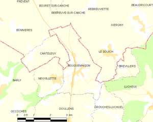
Bouquemaison
- commune in Somme, France
- Country:
- Postal Code: 80600
- Coordinates: 50° 12' 41" N, 2° 20' 14" E
- GPS tracks (wikiloc): [Link]
- Area: 7.15 sq km
- Population: 520

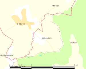
Brévillers
- commune in Somme, France
- Country:
- Postal Code: 80600
- Coordinates: 50° 12' 55" N, 2° 22' 40" E
- GPS tracks (wikiloc): [Link]
- Area: 1.83 sq km
- Population: 107


Rebreuve-sur-Canche
- commune in Pas-de-Calais, France
- Country:
- Postal Code: 62270
- Coordinates: 50° 15' 53" N, 2° 20' 27" E
- GPS tracks (wikiloc): [Link]
- Area: 8.28 sq km
- Population: 203