Lucheux (Lucheux)

- commune in Somme, France
- Country:

- Postal Code: 80600
- Coordinates: 50° 11' 48" N, 2° 24' 37" E


- GPS tracks (wikiloc): [Link]
- Area: 27.65 sq km
- Population: 545
- Wikipedia en: wiki(en)
- Wikipedia: wiki(fr)
- Wikidata storage: Wikidata: Q314783
- Wikipedia Commons Category: [Link]
- Freebase ID: [/m/0fb_7_]
- GeoNames ID: Alt: [2997218]
- SIREN number: [218004703]
- BnF ID: [15276973s]
- VIAF ID: Alt: [239679168]
- GND ID: Alt: [7566961-4]
- INSEE municipality code: 80495
Shares border with regions:


Warlincourt-lès-Pas
- commune in Pas-de-Calais, France
- Country:
- Postal Code: 62760
- Coordinates: 50° 10' 25" N, 2° 30' 20" E
- GPS tracks (wikiloc): [Link]
- Area: 5.19 sq km
- Population: 199

Sus-Saint-Léger
- commune in Pas-de-Calais, France
- Country:
- Postal Code: 62810
- Coordinates: 50° 14' 14" N, 2° 25' 47" E
- GPS tracks (wikiloc): [Link]
- Area: 7.31 sq km
- Population: 369

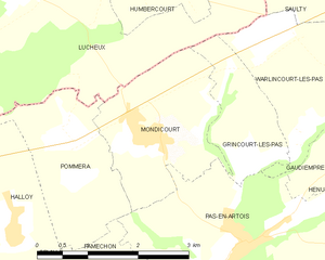
Mondicourt
- commune in Pas-de-Calais, France
- Country:
- Postal Code: 62760
- Coordinates: 50° 10' 25" N, 2° 27' 47" E
- GPS tracks (wikiloc): [Link]
- Area: 5.06 sq km
- Population: 625


Pommera
- commune in Pas-de-Calais, France
- Country:
- Postal Code: 62760
- Coordinates: 50° 10' 24" N, 2° 26' 20" E
- GPS tracks (wikiloc): [Link]
- Area: 4.42 sq km
- Population: 317
- Web site: [Link]


Ivergny
- commune in Pas-de-Calais, France
- Country:
- Postal Code: 62810
- Coordinates: 50° 14' 20" N, 2° 23' 33" E
- GPS tracks (wikiloc): [Link]
- Area: 7.34 sq km
- Population: 261


Grincourt-lès-Pas
- commune in Pas-de-Calais, France
- Country:
- Postal Code: 62760
- Coordinates: 50° 10' 7" N, 2° 29' 38" E
- GPS tracks (wikiloc): [Link]
- Area: 2.79 sq km
- Population: 29


Grouches-Luchuel
- commune in Somme, France
- Country:
- Postal Code: 80600
- Coordinates: 50° 10' 54" N, 2° 22' 56" E
- GPS tracks (wikiloc): [Link]
- Area: 9.02 sq km
- Population: 604


Saulty
- commune in Pas-de-Calais, France
- Country:
- Postal Code: 62158
- Coordinates: 50° 12' 45" N, 2° 31' 50" E
- GPS tracks (wikiloc): [Link]
- Area: 12.75 sq km
- Population: 763

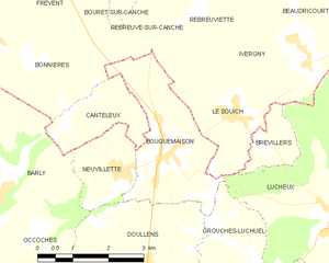
Bouquemaison
- commune in Somme, France
- Country:
- Postal Code: 80600
- Coordinates: 50° 12' 41" N, 2° 20' 14" E
- GPS tracks (wikiloc): [Link]
- Area: 7.15 sq km
- Population: 520

Humbercourt
- commune in Somme, France
- Country:
- Postal Code: 80600
- Coordinates: 50° 12' 37" N, 2° 27' 14" E
- GPS tracks (wikiloc): [Link]
- Area: 8.25 sq km
- Population: 264

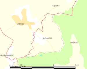
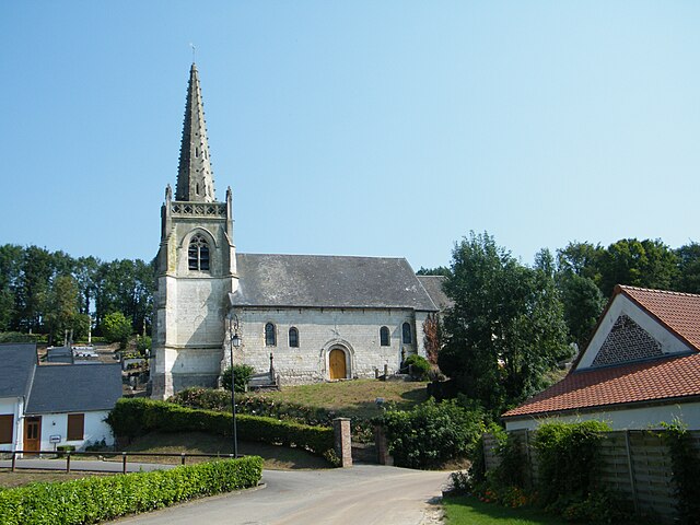
Brévillers
- commune in Somme, France
- Country:
- Postal Code: 80600
- Coordinates: 50° 12' 55" N, 2° 22' 40" E
- GPS tracks (wikiloc): [Link]
- Area: 1.83 sq km
- Population: 107


Le Souich
- commune in Pas-de-Calais, France
- Country:
- Postal Code: 62810
- Coordinates: 50° 13' 22" N, 2° 22' 1" E
- GPS tracks (wikiloc): [Link]
- Area: 5.11 sq km
- Population: 156

Couturelle
- commune in Pas-de-Calais, France
- Country:
- Postal Code: 62158
- Coordinates: 50° 12' 31" N, 2° 30' 0" E
- GPS tracks (wikiloc): [Link]
- Area: 2.1 sq km
- Population: 70


Halloy
- commune in Pas-de-Calais, France
- Country:
- Postal Code: 62760
- Coordinates: 50° 9' 28" N, 2° 25' 33" E
- GPS tracks (wikiloc): [Link]
- Area: 3.4 sq km
- Population: 225