Bourg-Madame (Bourg-Madame)

- commune in Pyrénées-Orientales, France
- Country:

- Postal Code: 66760
- Coordinates: 42° 26' 3" N, 1° 56' 38" E


- GPS tracks (wikiloc): [Link]
- Area: 7.85 sq km
- Population: 1214
- Web site: http://www.bourgmadame.fr
- Wikipedia en: wiki(en)
- Wikipedia: wiki(fr)
- Wikidata storage: Wikidata: Q329276
- Wikipedia Commons Category: [Link]
- Freebase ID: [/m/09f09r]
- Freebase ID: [/m/09f09r]
- GeoNames ID: Alt: [6615247]
- GeoNames ID: Alt: [6615247]
- SIREN number: [216600254]
- SIREN number: [216600254]
- BnF ID: [152709364]
- BnF ID: [152709364]
- VIAF ID: Alt: [234771248]
- VIAF ID: Alt: [234771248]
- OSM relation ID: [1820709]
- OSM relation ID: [1820709]
- Gran Enciclopèdia Catalana ID: [0031717]
- Gran Enciclopèdia Catalana ID: [0031717]
- INSEE municipality code: 66025
- INSEE municipality code: 66025
Shares border with regions:

Sainte-Léocadie
- commune in Pyrénées-Orientales, France
- Country:
- Postal Code: 66800
- Coordinates: 42° 26' 12" N, 2° 0' 12" E
- GPS tracks (wikiloc): [Link]
- Area: 8.88 sq km
- Population: 137
- Web site: [Link]

Osséja
- commune in Pyrénées-Orientales, France
- Country:
- Postal Code: 66340
- Coordinates: 42° 24' 58" N, 1° 58' 51" E
- GPS tracks (wikiloc): [Link]
- Area: 17.13 sq km
- Population: 1328
- Web site: [Link]

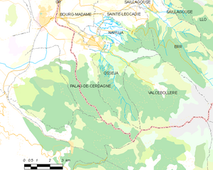
Palau-de-Cerdagne
- commune in Pyrénées-Orientales, France
- Country:
- Postal Code: 66340
- Coordinates: 42° 24' 56" N, 1° 57' 59" E
- GPS tracks (wikiloc): [Link]
- Area: 11.5 sq km
- Population: 409


Nahuja
- commune in Pyrénées-Orientales, France
- Country:
- Postal Code: 66340
- Coordinates: 42° 25' 30" N, 1° 59' 43" E
- GPS tracks (wikiloc): [Link]
- Area: 5.6 sq km
- Population: 76


Ur
- commune in Pyrénées-Orientales, France
- Country:
- Postal Code: 66760
- Coordinates: 42° 27' 43" N, 1° 56' 15" E
- GPS tracks (wikiloc): [Link]
- Area: 6.79 sq km
- Population: 358
- Web site: [Link]