
Bourges (Bourges)


- commune in Cher, France
- Country:

- Postal Code: 18000
- Coordinates: 47° 5' 1" N, 2° 23' 44" E


- GPS tracks (wikiloc): [Link]
- AboveSeaLevel: 153 м m
- Area: 68.74 sq km
- Population: 66071
- Web site: http://www.ville-bourges.fr
- Wikipedia en: wiki(en)
- Wikipedia: wiki(fr)
- Wikidata storage: Wikidata: Q132404
- Wikipedia Commons Gallery: [Link]
- Wikipedia Commons Category: [Link]
- Freebase ID: [/m/0l39s]
- Freebase ID: [/m/0l39s]
- Freebase ID: [/m/0l39s]
- Freebase ID: [/m/0l39s]
- Freebase ID: [/m/0l39s]
- Freebase ID: [/m/0l39s]
- GeoNames ID: Alt: [3031005]
- GeoNames ID: Alt: [3031005]
- GeoNames ID: Alt: [3031005]
- GeoNames ID: Alt: [3031005]
- GeoNames ID: Alt: [3031005]
- GeoNames ID: Alt: [3031005]
- SIREN number: [211800339]
- SIREN number: [211800339]
- SIREN number: [211800339]
- SIREN number: [211800339]
- SIREN number: [211800339]
- SIREN number: [211800339]
- BnF ID: [152493799]
- BnF ID: [152493799]
- BnF ID: [152493799]
- BnF ID: [152493799]
- BnF ID: [152493799]
- BnF ID: [152493799]
- VIAF ID: Alt: [135399156]
- VIAF ID: Alt: [135399156]
- VIAF ID: Alt: [135399156]
- VIAF ID: Alt: [135399156]
- VIAF ID: Alt: [135399156]
- VIAF ID: Alt: [135399156]
- GND ID: Alt: [4088156-8]
- GND ID: Alt: [4088156-8]
- GND ID: Alt: [4088156-8]
- GND ID: Alt: [4088156-8]
- GND ID: Alt: [4088156-8]
- GND ID: Alt: [4088156-8]
- archINFORM location ID: [3763]
- archINFORM location ID: [3763]
- archINFORM location ID: [3763]
- archINFORM location ID: [3763]
- archINFORM location ID: [3763]
- archINFORM location ID: [3763]
- Library of Congress authority ID: Alt: [n50052205]
- Library of Congress authority ID: Alt: [n50052205]
- Library of Congress authority ID: Alt: [n50052205]
- Library of Congress authority ID: Alt: [n50052205]
- Library of Congress authority ID: Alt: [n50052205]
- Library of Congress authority ID: Alt: [n50052205]
- MusicBrainz area ID: [417f5ba8-3ec4-41bd-af16-e6acf125c8bb]
- MusicBrainz area ID: [417f5ba8-3ec4-41bd-af16-e6acf125c8bb]
- MusicBrainz area ID: [417f5ba8-3ec4-41bd-af16-e6acf125c8bb]
- MusicBrainz area ID: [417f5ba8-3ec4-41bd-af16-e6acf125c8bb]
- MusicBrainz area ID: [417f5ba8-3ec4-41bd-af16-e6acf125c8bb]
- MusicBrainz area ID: [417f5ba8-3ec4-41bd-af16-e6acf125c8bb]
- Quora topic ID: [Bourges]
- Quora topic ID: [Bourges]
- Quora topic ID: [Bourges]
- Quora topic ID: [Bourges]
- Quora topic ID: [Bourges]
- Quora topic ID: [Bourges]
- SUDOC authorities ID: [026586541]
- SUDOC authorities ID: [026586541]
- SUDOC authorities ID: [026586541]
- SUDOC authorities ID: [026586541]
- SUDOC authorities ID: [026586541]
- SUDOC authorities ID: [026586541]
- Encyclopædia Britannica Online ID: [place/Bourges]
- Encyclopædia Britannica Online ID: [place/Bourges]
- Encyclopædia Britannica Online ID: [place/Bourges]
- Encyclopædia Britannica Online ID: [place/Bourges]
- Encyclopædia Britannica Online ID: [place/Bourges]
- Encyclopædia Britannica Online ID: [place/Bourges]
- Encyclopædia Universalis ID: [bourges]
- Encyclopædia Universalis ID: [bourges]
- Encyclopædia Universalis ID: [bourges]
- Encyclopædia Universalis ID: [bourges]
- Encyclopædia Universalis ID: [bourges]
- Encyclopædia Universalis ID: [bourges]
- EMLO location ID: [d8999686-0217-4f76-897c-5193a98526c2]
- EMLO location ID: [d8999686-0217-4f76-897c-5193a98526c2]
- EMLO location ID: [d8999686-0217-4f76-897c-5193a98526c2]
- EMLO location ID: [d8999686-0217-4f76-897c-5193a98526c2]
- EMLO location ID: [d8999686-0217-4f76-897c-5193a98526c2]
- EMLO location ID: [d8999686-0217-4f76-897c-5193a98526c2]
- Facebook Places ID: [104144552954355]
- Facebook Places ID: [104144552954355]
- Facebook Places ID: [104144552954355]
- Facebook Places ID: [104144552954355]
- Facebook Places ID: [104144552954355]
- Facebook Places ID: [104144552954355]
- Great Russian Encyclopedia Online ID: [1889266]
- Great Russian Encyclopedia Online ID: [1889266]
- Great Russian Encyclopedia Online ID: [1889266]
- Great Russian Encyclopedia Online ID: [1889266]
- Great Russian Encyclopedia Online ID: [1889266]
- Great Russian Encyclopedia Online ID: [1889266]
- Michelin Voyages ID: [europe/france/centre/cher/bourges]
- Michelin Voyages ID: [europe/france/centre/cher/bourges]
- Michelin Voyages ID: [europe/france/centre/cher/bourges]
- Michelin Voyages ID: [europe/france/centre/cher/bourges]
- Michelin Voyages ID: [europe/france/centre/cher/bourges]
- Michelin Voyages ID: [europe/france/centre/cher/bourges]
- INSEE municipality code: 18033
- INSEE municipality code: 18033
- INSEE municipality code: 18033
- INSEE municipality code: 18033
- INSEE municipality code: 18033
- INSEE municipality code: 18033
Shares border with regions:

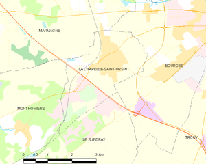
La Chapelle-Saint-Ursin
- commune in Cher, France
- Country:
- Postal Code: 18570
- Coordinates: 47° 3' 45" N, 2° 19' 30" E
- GPS tracks (wikiloc): [Link]
- Area: 7.83 sq km
- Population: 3407

Saint-Doulchard
- commune in Cher, France
- Country:
- Postal Code: 18230
- Coordinates: 47° 5' 59" N, 2° 22' 22" E
- GPS tracks (wikiloc): [Link]
- Area: 24.01 sq km
- Population: 9431
- Web site: [Link]
Soye-en-Septaine
- commune in Cher, France
- Country:
- Postal Code: 18340
- Coordinates: 47° 1' 36" N, 2° 29' 21" E
- GPS tracks (wikiloc): [Link]
- Area: 18.57 sq km
- Population: 578

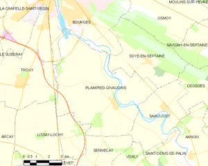
Plaimpied-Givaudins
- commune in Cher, France
- Country:
- Postal Code: 18340
- Coordinates: 46° 59' 55" N, 2° 27' 15" E
- GPS tracks (wikiloc): [Link]
- Area: 40.51 sq km
- Population: 1959


Marmagne
- commune in Cher, France
- Country:
- Postal Code: 18500
- Coordinates: 47° 6' 5" N, 2° 17' 1" E
- GPS tracks (wikiloc): [Link]
- Area: 37.66 sq km
- Population: 2005


Osmoy
- commune in Cher, France
- Country:
- Postal Code: 18390
- Coordinates: 47° 4' 24" N, 2° 31' 22" E
- GPS tracks (wikiloc): [Link]
- Area: 22.63 sq km
- Population: 316


Saint-Michel-de-Volangis
- commune in Cher, France
- Country:
- Postal Code: 18390
- Coordinates: 47° 8' 52" N, 2° 29' 19" E
- GPS tracks (wikiloc): [Link]
- Area: 17.42 sq km
- Population: 477


Le Subdray
- commune in Cher, France
- Country:
- Postal Code: 18570
- Coordinates: 47° 0' 39" N, 2° 17' 40" E
- GPS tracks (wikiloc): [Link]
- Area: 20.28 sq km
- Population: 945

Trouy
- commune in Cher, France
- Country:
- Postal Code: 18570
- Coordinates: 47° 0' 37" N, 2° 21' 28" E
- GPS tracks (wikiloc): [Link]
- Area: 23.19 sq km
- Population: 3942
- Web site: [Link]
Vasselay
- commune in Cher, France
- Country:
- Postal Code: 18110
- Coordinates: 47° 9' 28" N, 2° 23' 18" E
- GPS tracks (wikiloc): [Link]
- Area: 20.21 sq km
- Population: 1410
- Web site: [Link]


Fussy
- commune in Cher, France
- Country:
- Postal Code: 18110
- Coordinates: 47° 8' 41" N, 2° 25' 44" E
- GPS tracks (wikiloc): [Link]
- Area: 11.08 sq km
- Population: 1980
- Web site: [Link]


Saint-Germain-du-Puy
- commune in Cher, France
- Country:
- Postal Code: 18390
- Coordinates: 47° 5' 57" N, 2° 28' 52" E
- GPS tracks (wikiloc): [Link]
- Area: 21.63 sq km
- Population: 5076