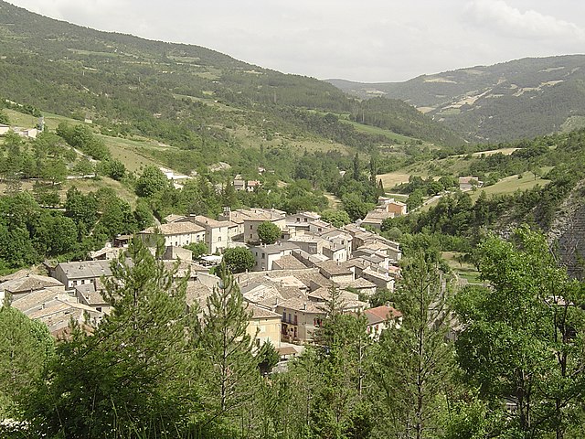
Bouvières (Bouvières)

- commune in Drôme, France
 Hiking in Bouvières
Bouvières is a picturesque area located in the Alpes-Maritimes department of France. It's part of the scenic region of Provence-Alpes-Côte d'Azur, known for its diverse landscapes, including mountains, forests, and stunning views. Hiking in Bouvières offers a variety of trails suitable for all skill levels, from gentle walks to more challenging hikes.
Key Features of Hiking in Bouvières:
-
Scenic Trails: The trails in Bouvières are characterized by beautiful natural scenery, including lush forests, rocky outcrops, and panoramic views of the surrounding mountains and valleys.
-
Flora and Fauna: The region is rich in biodiversity. Hikers may encounter various plant species, wildflowers, and wildlife along the trails.
-
Historical Sites: Bouvières and its surroundings may also feature historical points of interest, such as old stone villages, ruins, and ancient pathways that reflect the rich cultural history of the area.
-
Trail Difficulty: The area offers a range of trails, from easy walks that can be enjoyed by families to more challenging hikes that may require proper gear and experience.
-
Best Time to Visit: Spring and early autumn are ideal for hiking in Bouvières, as the weather is generally mild and the landscapes are vibrant with flora. Summer can be hot, while winter may bring snow to the higher elevations.
-
Safety and Preparedness: Always check trail conditions before heading out, carry sufficient water, and wear appropriate footwear. Consider hiking with a map or GPS, and let someone know your hiking plans.
Before embarking on a hike, you might find it useful to consult local hiking guides or websites for detailed trail maps, conditions, and elevation profiles to enhance your experience in Bouvières.
- Country:

- Postal Code: 26460
- Coordinates: 44° 30' 58" N, 5° 12' 56" E


- GPS tracks (wikiloc): [Link]
- Area: 25.05 sq km
- Population: 145
- Wikipedia en: wiki(en)
- Wikipedia: wiki(fr)
- Wikidata storage: Wikidata: Q384675
- Wikipedia Commons Category: [Link]
- Freebase ID: [/m/03mgkw3]
- GeoNames ID: Alt: [6447898]
- SIREN number: [212600605]
- WOEID: [581442]
- INSEE municipality code: 26060
Shares border with regions:

Saint-Nazaire-le-Désert
- commune in Drôme, France
Hiking in Saint-Nazaire-le-Désert
Saint-Nazaire-le-Désert is a charming commune located in the Drôme department in southeastern France. It offers a unique blend of natural beauty, historical significance, and outdoor activities, making it a great destination for hiking enthusiasts....
- Country:
- Postal Code: 26340
- Coordinates: 44° 34' 12" N, 5° 16' 33" E
- GPS tracks (wikiloc): [Link]
- Area: 46.62 sq km
- Population: 174


Vesc
- commune in Drôme, France
Hiking in Vesc
Vesc, a charming village in the Drôme region of southeastern France, is surrounded by beautiful landscapes that offer excellent hiking opportunities. The area is known for its picturesque hills, forests, and vibrant agricultural lands, making it perfect for outdoor enthusiasts....
- Country:
- Postal Code: 26220
- Coordinates: 44° 31' 19" N, 5° 9' 3" E
- GPS tracks (wikiloc): [Link]
- Area: 40.48 sq km
- Population: 283


Crupies
- commune in Drôme, France
Hiking in Crupies
Crupies is a small commune in France, located in the Drôme department in the Auvergne-Rhône-Alpes region. While it may not be widely recognized as a hiking destination compared to more famous areas like the Alps or the Pyrenees, Crupies and its surrounding countryside offer some charming trails and routes for those looking to explore the area's natural beauty....
- Country:
- Postal Code: 26460
- Coordinates: 44° 33' 14" N, 5° 10' 22" E
- GPS tracks (wikiloc): [Link]
- Area: 13.16 sq km
- Population: 95


Bourdeaux
- commune in Drôme, France
Hiking in Bourdeaux
Bordeaux, while primarily known for its wine and culinary scene, also offers some beautiful hiking opportunities in and around the city, as well as in the broader Aquitaine region of southwestern France. Here are some highlights:...
- Country:
- Postal Code: 26460
- Coordinates: 44° 35' 11" N, 5° 8' 4" E
- GPS tracks (wikiloc): [Link]
- Area: 23.11 sq km
- Population: 626


Chaudebonne
- commune in Drôme, France
Hiking in Chaudebonne
Chaudebonne, located in the picturesque region of the French Alps, offers some stunning hiking opportunities. The area is known for its breathtaking mountain scenery, lush valleys, and diverse wildlife. Here are a few highlights to consider when planning a hike in this region:...
- Country:
- Postal Code: 26110
- Coordinates: 44° 28' 36" N, 5° 13' 7" E
- GPS tracks (wikiloc): [Link]
- Area: 20.77 sq km
- Population: 53

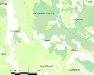
Gumiane
- commune in Drôme, France
Hiking in Gumiane
Gumiane is a lesser-known yet beautiful hiking destination located in a scenic area that showcases diverse landscapes, rich flora, and fauna. While specific trails and conditions can vary, here are some general tips and insights for hiking in Gumiane:...
- Country:
- Postal Code: 26470
- Coordinates: 44° 30' 36" N, 5° 16' 34" E
- GPS tracks (wikiloc): [Link]
- Area: 8.92 sq km
- Population: 21