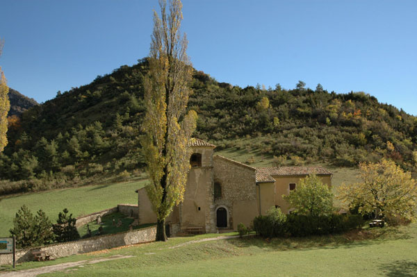
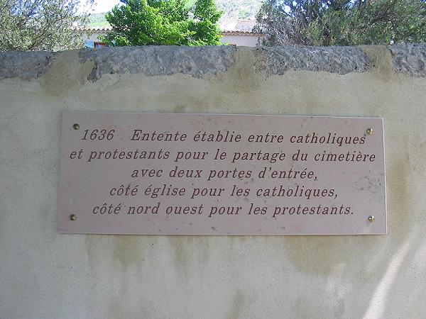
Saint-Nazaire-le-Désert (Saint-Nazaire-le-Désert)

- commune in Drôme, France
 Hiking in Saint-Nazaire-le-Désert
Saint-Nazaire-le-Désert is a charming commune located in the Drôme department in southeastern France. It offers a unique blend of natural beauty, historical significance, and outdoor activities, making it a great destination for hiking enthusiasts.
Hiking Trails
-
Local Trails: The area around Saint-Nazaire-le-Désert features various marked trails that allow hikers to explore the stunning landscapes, including forests, hills, and valleys. These trails are generally well-maintained and cater to different skill levels, ensuring that both novice and experienced hikers can enjoy their experience.
-
Scenic Views: Hikers can enjoy breathtaking views of the surrounding countryside, including the picturesque Drôme Provençale and the nearby Vercors massif. Look for vantage points along the trails for opportunities to photograph the landscape, especially during sunrise or sunset.
-
Historical Routes: Some routes may also lead you to historical sites and landmarks, such as old chapels or remnants of traditional stone structures, adding cultural significance to your hike.
Tips for Hiking in Saint-Nazaire-le-Désert
-
Seasonal Considerations: The best time for hiking is typically in spring and early autumn when temperatures are mild, and the scenery is lush and vibrant. Summer can be hot, so make sure to hydrate and take frequent breaks if you're hiking during this time.
-
Preparation: Always check the weather before heading out and dress accordingly. It's advisable to wear sturdy hiking boots and carry a map, water, snacks, and a basic first-aid kit.
-
Respect Nature: Follow the Leave No Trace principles by sticking to designated paths, packing out what you bring in, and respecting wildlife.
-
Local Guidance: Consider joining a local hiking group or hiring a guide for a more in-depth exploration of the area. They can provide valuable insights into the natural environment and local history.
Additional Activities
-
Mountain Biking: If you're interested in more adventurous outdoor activities, some trails around the area may be suitable for mountain biking.
-
Wildlife Watching: Keep an eye out for local wildlife, including various bird species and larger animals in their natural habitat.
-
Cultural Exploration: After your hike, take some time to explore the commune itself, enjoy local cuisine, and visit any historical sites.
Overall, hiking in Saint-Nazaire-le-Désert can be a rewarding experience, both physically and mentally, amidst stunning natural surroundings and a rich cultural backdrop.
- Country:

- Postal Code: 26340
- Coordinates: 44° 34' 12" N, 5° 16' 33" E


- GPS tracks (wikiloc): [Link]
- Area: 46.62 sq km
- Population: 174
- Wikipedia en: wiki(en)
- Wikipedia: wiki(fr)
- Wikidata storage: Wikidata: Q219387
- Wikipedia Commons Category: [Link]
- Freebase ID: [/m/0h4rrb]
- SIREN number: [212603211]
- BnF ID: [152531812]
- VIAF ID: Alt: [234292164]
- PACTOLS thesaurus ID: [pcrtGQ66PbjSWs]
- INSEE municipality code: 26321
Shares border with regions:
Les Tonils
- commune in Drôme, France
Hiking in Les Tonils
Les Tonils, located in the province of Aosta Valley in Italy, is a beautiful area for hiking, known for its stunning landscapes and diverse flora and fauna. The region offers routes that cater to various skill levels, from easy day hikes to more challenging treks....
- Country:
- Postal Code: 26460
- Coordinates: 44° 34' 55" N, 5° 11' 57" E
- GPS tracks (wikiloc): [Link]
- Area: 13 sq km
- Population: 17
Volvent
- commune in Drôme, France
Hiking in Volvent
It seems there might be a bit of confusion; there isn't a widely recognized hiking destination called "Volvent." However, if you meant "Vallentuna" (located in Sweden) or perhaps "volcanic" regions like those in Iceland, or if you're referring to a different location with a similar name, please clarify....
- Country:
- Postal Code: 26470
- Coordinates: 44° 33' 36" N, 5° 20' 40" E
- GPS tracks (wikiloc): [Link]
- Area: 16.73 sq km
- Population: 35

Rochefourchat
- commune in Drôme, France
Hiking in Rochefourchat
Rochefourchat is a lesser-known destination in the Drôme region of southeastern France, offering a unique hiking experience amid stunning natural landscapes. Here's what you can expect when hiking in Rochefourchat:...
- Country:
- Postal Code: 26340
- Coordinates: 44° 35' 55" N, 5° 14' 50" E
- GPS tracks (wikiloc): [Link]
- Area: 12.74 sq km
- Population: 1


Bourdeaux
- commune in Drôme, France
Hiking in Bourdeaux
Bordeaux, while primarily known for its wine and culinary scene, also offers some beautiful hiking opportunities in and around the city, as well as in the broader Aquitaine region of southwestern France. Here are some highlights:...
- Country:
- Postal Code: 26460
- Coordinates: 44° 35' 11" N, 5° 8' 4" E
- GPS tracks (wikiloc): [Link]
- Area: 23.11 sq km
- Population: 626


Bouvières
- commune in Drôme, France
Hiking in Bouvières
Bouvières is a picturesque area located in the Alpes-Maritimes department of France. It's part of the scenic region of Provence-Alpes-Côte d'Azur, known for its diverse landscapes, including mountains, forests, and stunning views. Hiking in Bouvières offers a variety of trails suitable for all skill levels, from gentle walks to more challenging hikes....
- Country:
- Postal Code: 26460
- Coordinates: 44° 30' 58" N, 5° 12' 56" E
- GPS tracks (wikiloc): [Link]
- Area: 25.05 sq km
- Population: 145
Pradelle
- commune in Drôme, France
Hiking in Pradelle
Pradelle, located in the Drôme department in southeastern France, offers a delightful setting for hiking enthusiasts. Nestled in the beautiful landscape of the Drôme Provençale region, it boasts picturesque views, rolling hills, and diverse flora and fauna....
- Country:
- Postal Code: 26340
- Coordinates: 44° 36' 29" N, 5° 17' 31" E
- GPS tracks (wikiloc): [Link]
- Area: 12.92 sq km
- Population: 19

Brette
- commune in Drôme, France
Hiking in Brette
Hiking in Brette, which is part of the beautiful French region of Auvergne-Rhône-Alpes, offers stunning landscapes, diverse trails, and opportunities to experience nature at its finest. Here’s an overview of what you can expect:...
- Country:
- Postal Code: 26340
- Coordinates: 44° 35' 16" N, 5° 18' 39" E
- GPS tracks (wikiloc): [Link]
- Area: 15.5 sq km
- Population: 39

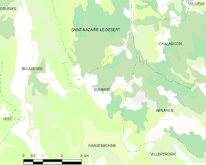
Gumiane
- commune in Drôme, France
Hiking in Gumiane
Gumiane is a lesser-known yet beautiful hiking destination located in a scenic area that showcases diverse landscapes, rich flora, and fauna. While specific trails and conditions can vary, here are some general tips and insights for hiking in Gumiane:...
- Country:
- Postal Code: 26470
- Coordinates: 44° 30' 36" N, 5° 16' 34" E
- GPS tracks (wikiloc): [Link]
- Area: 8.92 sq km
- Population: 21
Chalancon
- commune in Drôme, France
Hiking in Chalancon
Chalancon, a picturesque village located in the Drôme department of southeastern France, offers stunning landscapes and a variety of hiking opportunities for outdoor enthusiasts. Nestled in the foothills of the Vercors and near the stunning Baronnies Provençales National Park, the area is characterized by its rolling hills, diverse flora and fauna, and charming rural scenery....
- Country:
- Postal Code: 26470
- Coordinates: 44° 30' 34" N, 5° 20' 51" E
- GPS tracks (wikiloc): [Link]
- Area: 36 sq km
- Population: 44