Bransles (Bransles)

- commune in Seine-et-Marne, France
- Country:

- Postal Code: 77620
- Coordinates: 48° 9' 7" N, 2° 50' 5" E


- GPS tracks (wikiloc): [Link]
- Area: 13.85 sq km
- Population: 553
- Wikipedia en: wiki(en)
- Wikipedia: wiki(fr)
- Wikidata storage: Wikidata: Q1422111
- Wikipedia Commons Category: [Link]
- Freebase ID: [/m/02ppxqr]
- Freebase ID: [/m/02ppxqr]
- GeoNames ID: Alt: [6614489]
- GeoNames ID: Alt: [6614489]
- SIREN number: [217700509]
- SIREN number: [217700509]
- BnF ID: [15275391t]
- BnF ID: [15275391t]
- INSEE municipality code: 77050
- INSEE municipality code: 77050
Shares border with regions:

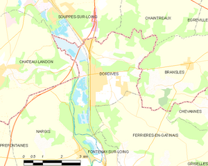
Dordives
- commune in Loiret, France
- Country:
- Postal Code: 45680
- Coordinates: 48° 8' 36" N, 2° 46' 2" E
- GPS tracks (wikiloc): [Link]
- Area: 15.18 sq km
- Population: 3301
- Web site: [Link]


Égreville
- commune in Seine-et-Marne, France
- Country:
- Postal Code: 77620
- Coordinates: 48° 10' 38" N, 2° 52' 17" E
- GPS tracks (wikiloc): [Link]
- Area: 31.84 sq km
- Population: 2159
- Web site: [Link]


Chevannes
- commune in Loiret, France
- Country:
- Postal Code: 45210
- Coordinates: 48° 8' 5" N, 2° 51' 34" E
- GPS tracks (wikiloc): [Link]
- Area: 11.99 sq km
- Population: 320

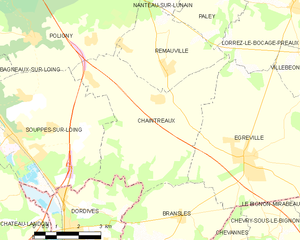
Chaintreaux
- commune in Seine-et-Marne, France
- Country:
- Postal Code: 77460
- Coordinates: 48° 11' 59" N, 2° 49' 10" E
- GPS tracks (wikiloc): [Link]
- Area: 23.92 sq km
- Population: 918

Ferrières-en-Gâtinais
- commune in Loiret, France
- Country:
- Postal Code: 45210
- Coordinates: 48° 5' 25" N, 2° 47' 23" E
- GPS tracks (wikiloc): [Link]
- Area: 27.32 sq km
- Population: 3646
- Web site: [Link]