Braunau am Inn (Braunau am Inn)

- municipality in Austria
 Hiking in Braunau am Inn
Braunau am Inn, located in Austria near the border with Germany, is surrounded by beautiful landscapes that offer various hiking opportunities. The region features gentle hills, lush forests, and picturesque views of the Inn River and the surrounding countryside.
Hiking Trails and Areas:
-
Innviertel Region: The Innviertel area provides a mix of gentle walks and more challenging hikes. You can explore well-marked trails that wind through the countryside, passing by charming villages.
-
Mühlviertel Region: A bit further away, the Mühlviertel offers more elevation and a variety of trails that lead through dense forests and past natural springs.
-
Local Nature Reserves: Explore the local nature reserves around Braunau, such as the Innauen nature area, where you can enjoy scenic routes along the river and observe local wildlife.
-
Signposted Hiking Trails: Many signposted trails are suitable for different skill levels. These trails usually offer a combination of beautiful landscapes and historical points of interest.
-
Hiking to Nearby Peaks: If you're up for a drive, the Salzkammergut region is not too far and provides more advanced hiking options in the mountains with breathtaking lakes and views.
Preparation Tips:
- Weather Considerations: Always check the weather forecast before heading out, as conditions can change quickly in the Alps.
- Footwear: Sturdy hiking boots are essential, especially if you're venturing onto uneven terrain.
- Gear: Bring a backpack with water, snacks, a map, and a first-aid kit for longer hikes.
- Local Regulations: Be aware of any local guidelines or restrictions, especially when trekking in nature reserves.
Best Time to Hike:
The best time for hiking in Braunau am Inn is typically from late spring to early autumn (May to September), when the weather is pleasant and the trails are accessible.
Resources:
Local tourism offices can provide maps, brochures, and additional information on guided hikes if you want to explore the area with a local guide. It’s a great way to appreciate the scenery and history while ensuring you stay on the right path.
Whether you are looking for a leisurely stroll or a more challenging hike, Braunau am Inn and its surroundings have something to offer for every hiking enthusiast!
- Country:

- Postal Code: 5289; 5283; 5280
- Local Dialing Code: 07722
- Licence Plate Code: BR
- Coordinates: 48° 15' 30" N, 13° 2' 0" E


- GPS tracks (wikiloc): [Link]
- AboveSeaLevel: 352 м m
- Area: 24.84 sq km
- Population: 17095
- Web site: http://www.braunau.at/
- Wikipedia en: wiki(en)
- Wikipedia: wiki(de)
- Wikidata storage: Wikidata: Q131128
- Wikipedia Commons Gallery: [Link]
- Wikipedia Commons Category: [Link]
- Freebase ID: [/m/0196c5]
- GeoNames ID: Alt: [2781520]
- BnF ID: [12354195r]
- VIAF ID: Alt: [143090962]
- GND ID: Alt: [4008037-7]
- archINFORM location ID: [5700]
- MusicBrainz area ID: [36809adf-f7e9-468d-b2fe-3dbefcbf63f2]
- WOEID: [12674246]
- Encyclopædia Britannica Online ID: [place/Braunau]
- Facebook Places ID: [110152405674314]
- Austrian municipality key: [40404]
- Digital Atlas of the Roman Empire ID: [42759]
- NKCR AUT ID: [ge272701]
Shares border with regions:

Simbach am Inn
- municipality of Germany
Hiking in Simbach am Inn
Simbach am Inn, located on the border between Germany and Austria, offers a variety of hiking opportunities that showcase the natural beauty of the region. Here are some things to consider if you're planning a hiking excursion in or around Simbach am Inn:...
- Country:

- Postal Code: 84359
- Local Dialing Code: 08571
- Licence Plate Code: PAN
- Coordinates: 48° 16' 0" N, 13° 1' 0" E
- GPS tracks (wikiloc): [Link]
- AboveSeaLevel: 350 м m
- Area: 47.33 sq km
- Population: 8697
- Web site: [Link]
Überackern
- municipality in Austria
Hiking in Überackern
Überackern is a beautiful location for hiking, nestled in Austria. While the specifics can vary based on the specific trails and areas you choose, here are some general aspects to consider when hiking in and around Überackern:...
- Country:
- Postal Code: 5122
- Local Dialing Code: 07727
- Licence Plate Code: BR
- Coordinates: 48° 11' 35" N, 12° 52' 36" E
- GPS tracks (wikiloc): [Link]
- AboveSeaLevel: 356 м m
- Area: 27.1 sq km
- Population: 685
- Web site: [Link]
Kirchdorf am Inn
- municipality of Germany
Hiking in Kirchdorf am Inn
Kirchdorf am Inn is a charming village located in Bavaria, Germany, near the border with Austria. The area is known for its beautiful landscapes, making it a great destination for hiking enthusiasts. Here are some highlights and tips for hiking in and around Kirchdorf am Inn:...
- Country:
- Postal Code: 84375
- Local Dialing Code: 08571
- Licence Plate Code: PAN
- Coordinates: 48° 15' 0" N, 12° 59' 0" E
- GPS tracks (wikiloc): [Link]
- AboveSeaLevel: 359 м m
- Area: 31.64 sq km
- Population: 4064
- Web site: [Link]

Burgkirchen
- municipality in Austria
Hiking in Burgkirchen
Burgkirchen, located in Austria’s picturesque Upper Austria region, offers a variety of hiking opportunities that cater to different skill levels. The area is characterized by beautiful landscapes, including rolling hills, forests, and rivers, making it perfect for both casual walkers and more experienced hikers....
- Country:
- Local Dialing Code: 07724
- Licence Plate Code: BR
- Coordinates: 48° 12' 16" N, 13° 6' 5" E
- GPS tracks (wikiloc): [Link]
- AboveSeaLevel: 393 м m
- Area: 45.91 sq km
- Population: 2661
- Web site: [Link]


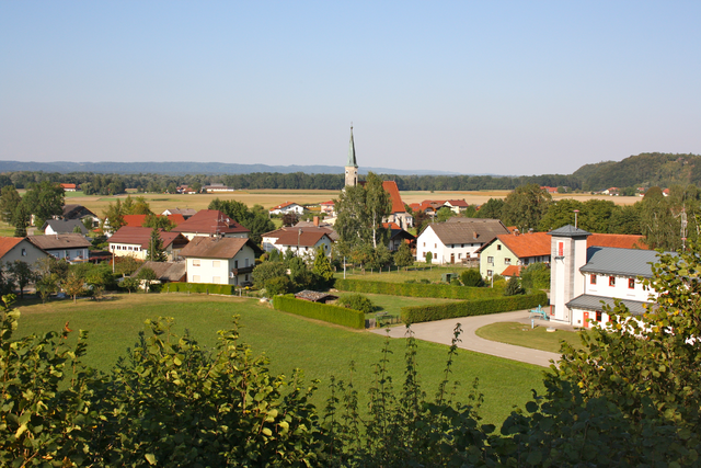
Sankt Peter am Hart
- town in Austria
Hiking in Sankt Peter am Hart
Sankt Peter am Hart, located in the Austrian state of Upper Austria, is a charming village that offers various outdoor activities, including hiking. The region is known for its picturesque landscapes, featuring rolling hills, lush forests, and scenic views, making it a great destination for nature lovers and hikers....
- Country:
- Postal Code: 4963
- Local Dialing Code: 07722
- Licence Plate Code: BR
- Coordinates: 48° 15' 15" N, 13° 5' 40" E
- GPS tracks (wikiloc): [Link]
- AboveSeaLevel: 372 м m
- Area: 2285 sq km
- Population: 2447
- Web site: [Link]


Neukirchen an der Enknach
- municipality in Austria
Hiking in Neukirchen an der Enknach
Neukirchen an der Enknach is a picturesque village located in Bavaria, Germany, known for its beautiful natural landscapes and outdoor recreational activities, including hiking. The region is characterized by rolling hills, lush forests, and scenic fields, making it an ideal destination for both casual walkers and avid hikers....
- Country:
- Postal Code: 5145
- Local Dialing Code: 07729
- Licence Plate Code: BR
- Coordinates: 48° 10' 40" N, 13° 2' 50" E
- GPS tracks (wikiloc): [Link]
- AboveSeaLevel: 411 м m
- Area: 33.26 sq km
- Population: 2212
- Web site: [Link]
Schwand im Innkreis
- municipality in Austria
Hiking in Schwand im Innkreis
Schwand im Innkreis, located in Austria, offers a picturesque backdrop for hiking enthusiasts. This region is part of Upper Austria and is characterized by its beautiful landscapes, rolling hills, and lush greenery, making it an ideal spot for outdoor activities....
- Country:
- Postal Code: 5134
- Local Dialing Code: 07728
- Licence Plate Code: BR
- Coordinates: 48° 10' 42" N, 12° 58' 5" E
- GPS tracks (wikiloc): [Link]
- AboveSeaLevel: 423 м m
- Area: 17.13 sq km
- Population: 972
- Web site: [Link]