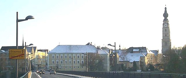
Überackern (Überackern)
- municipality in Austria
Überackern is a beautiful location for hiking, nestled in Austria. While the specifics can vary based on the specific trails and areas you choose, here are some general aspects to consider when hiking in and around Überackern:
1. :
- The area offers a variety of scenic trails that provide stunning views of the surrounding landscape, including mountains, forests, and potentially lakes.
2. :
- There are likely a range of trails suitable for different skill levels, from easy walks well-suited for families to more challenging hikes for experienced hikers. Make sure to check the trail difficulty before heading out.
3. :
- The region may be home to diverse flora and fauna. Keep an eye out for local wildlife and enjoy the natural beauty around you.
4. :
- Weather in Austria can change quickly, especially in mountainous regions. Ensure you check the weather forecast before you hike and dress in layers to stay comfortable.
5. :
- Respect local regulations and guidelines for hikers, which may include staying on marked trails and following leave-no-trace principles to preserve the natural environment.
6. :
- If you’re unfamiliar with the area or want to learn more about the local ecology and culture, consider joining a guided hiking tour.
7. :
- Make sure to carry sufficient water, snacks, a map, or GPS device. Inform someone about your hiking plans, especially if you're going alone.
8. :
- Spring and autumn typically offer the best weather for hiking with pleasant temperatures and beautiful scenery. Summer may also be nice, but can be hot, while winter hiking would require special gear and precautions.
It's always a great idea to stop by a local visitor center or consult local hike websites for updated information on trail conditions, tips, and any seasonal changes that might affect your hike. Enjoy your adventure in Überackern!
- Country:

- Postal Code: 5122
- Local Dialing Code: 07727
- Licence Plate Code: BR
- Coordinates: 48° 11' 35" N, 12° 52' 36" E


- GPS tracks (wikiloc): [Link]
- AboveSeaLevel: 356 м m
- Area: 27.1 sq km
- Population: 685
- Web site: http://www.ueberackern.at
- Wikipedia en: wiki(en)
- Wikipedia: wiki(de)
- Wikidata storage: Wikidata: Q331264
- Wikipedia Commons Category: [Link]
- Freebase ID: [/m/03gv2tw]
- GeoNames ID: Alt: [2763198]
- VIAF ID: Alt: [244780171]
- Austrian municipality key: [40445]
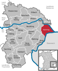
Shares border with regions:


Braunau am Inn
- municipality in Austria
Braunau am Inn, located in Austria near the border with Germany, is surrounded by beautiful landscapes that offer various hiking opportunities. The region features gentle hills, lush forests, and picturesque views of the Inn River and the surrounding countryside....
- Country:

- Postal Code: 5289; 5283; 5280
- Local Dialing Code: 07722
- Licence Plate Code: BR
- Coordinates: 48° 15' 30" N, 13° 2' 0" E


- GPS tracks (wikiloc): [Link]
- AboveSeaLevel: 352 м m
- Area: 24.84 sq km
- Population: 17095
- Web site: [Link]


Haiming
- municipality of Germany
Haiming, located in Bavaria, Germany, is an excellent destination for hiking enthusiasts. Nestled close to the Alps, it offers picturesque landscapes, beautiful trails, and a variety of outdoor activities. Here are some highlights about hiking in and around Haiming:...
- Country:

- Postal Code: 84533
- Local Dialing Code: 08678
- Coordinates: 48° 12' 45" N, 12° 53' 16" E


- GPS tracks (wikiloc): [Link]
- AboveSeaLevel: 363 м m
- Area: 28.67 sq km
- Population: 2103
- Web site: [Link]
Gilgenberg am Weilhart
- municipality in Austria
 Hiking in Gilgenberg am Weilhart
Gilgenberg am Weilhart is a picturesque village in Austria, located in the state of Upper Austria. While it might not be as well-known as some of the larger hiking destinations, it offers a number of scenic trails and beautiful countryside, making it a great spot for hiking enthusiasts....
- Country:

- Postal Code: 5133
- Local Dialing Code: 07728
- Licence Plate Code: BR
- Coordinates: 48° 7' 54" N, 12° 56' 21" E


- GPS tracks (wikiloc): [Link]
- AboveSeaLevel: 466 м m
- Area: 26.58 sq km
- Population: 1327
- Web site: [Link]


Kirchdorf am Inn
- municipality of Germany
Kirchdorf am Inn is a charming village located in Bavaria, Germany, near the border with Austria. The area is known for its beautiful landscapes, making it a great destination for hiking enthusiasts. Here are some highlights and tips for hiking in and around Kirchdorf am Inn:...
- Country:

- Postal Code: 84375
- Local Dialing Code: 08571
- Licence Plate Code: PAN
- Coordinates: 48° 15' 0" N, 12° 59' 0" E


- GPS tracks (wikiloc): [Link]
- AboveSeaLevel: 359 м m
- Area: 31.64 sq km
- Population: 4064
- Web site: [Link]
Schwand im Innkreis
- municipality in Austria
Schwand im Innkreis, located in Austria, offers a picturesque backdrop for hiking enthusiasts. This region is part of Upper Austria and is characterized by its beautiful landscapes, rolling hills, and lush greenery, making it an ideal spot for outdoor activities....
- Country:

- Postal Code: 5134
- Local Dialing Code: 07728
- Licence Plate Code: BR
- Coordinates: 48° 10' 42" N, 12° 58' 5" E


- GPS tracks (wikiloc): [Link]
- AboveSeaLevel: 423 м m
- Area: 17.13 sq km
- Population: 972
- Web site: [Link]


Hochburg-Ach
- municipality in Austria
Hochburg-Ach, located in Bavaria, Germany, near the Austrian border, offers a variety of hiking opportunities that showcase the beautiful landscapes of the region. Here are some key points about hiking in Hochburg-Ach:...
- Country:

- Postal Code: 5122
- Local Dialing Code: 07727
- Licence Plate Code: BR
- Coordinates: 48° 7' 50" N, 12° 52' 40" E


- GPS tracks (wikiloc): [Link]
- AboveSeaLevel: 462 м m
- Area: 40.12 sq km
- Population: 3236
- Web site: [Link]