Buis-les-Baronnies (Buis-les-Baronnies)

- commune in Drôme, France
 Hiking in Buis-les-Baronnies
Buis-les-Baronnies, located in the Drome department of southeastern France, is a fantastic destination for hiking enthusiasts. Nestled in the picturesque Baronnies region, the area boasts diverse landscapes, varying altitudes, and a mild Mediterranean climate, making it ideal for outdoor activities.
Trail Features:
- Variety of Trails: Buis-les-Baronnies offers a wide range of hiking trails suitable for all levels, from easy walks suitable for families to more challenging routes for experienced hikers.
- Scenic Views: Hikers can enjoy stunning views of the surrounding mountains, lush valleys, and the unique landscape of the Drôme Provençale. Many trails provide panoramic views, especially from higher elevations.
- Flora and Fauna: The region is rich in biodiversity, and hikers may encounter a variety of plant species, wildflowers, and wildlife, including birds, butterflies, and, occasionally, deer.
Popular Hikes:
- Col de l’Ange: This is a popular trail that offers breathtaking views of the surrounding valleys and mountains. It’s moderately challenging, making it suitable for more experienced hikers.
- Le Mont Ventoux: While not directly in Buis-les-Baronnies, it's close enough for a day hike to explore this iconic peak known for its challenging trails and stunning views.
- Sentier des 3 Moulins: An easier trail that takes hikers past historical sites, including old windmills. This is ideal for families or those looking for a casual hike.
Practical Tips:
- Best Time to Hike: The ideal seasons for hiking here are spring (April to June) and early autumn (September to October) when temperatures are moderate and the landscapes are vibrant.
- Preparation: Always check the weather before heading out, wear appropriate hiking shoes, and carry enough water and snacks. Some trails can be remote, so a map or a GPS app is advisable.
- Respect Nature: Follow the Leave No Trace principles to help preserve the natural beauty of the region.
Local Amenities:
Buis-les-Baronnies has charming local shops, markets, and cafes where hikers can refuel after a day on the trails. Additionally, there are opportunities for guided hikes if you prefer a local expert to show you around.
Overall, Buis-les-Baronnies is a hidden gem for hiking, combining natural beauty, cultural richness, and accessible trails. Whether you’re a novice or an experienced hiker, you'll find plenty to explore in this beautiful region.
- Country:

- Postal Code: 26170
- Coordinates: 44° 16' 31" N, 5° 16' 28" E


- GPS tracks (wikiloc): [Link]
- Area: 33.74 sq km
- Population: 2287
- Web site: http://www.buislesbaronnies.fr
- Wikipedia en: wiki(en)
- Wikipedia: wiki(fr)
- Wikidata storage: Wikidata: Q333608
- Wikipedia Commons Category: [Link]
- Freebase ID: [/m/03g_hlj]
- GeoNames ID: Alt: [3029603]
- SIREN number: [212600639]
- BnF ID: [152529246]
- VIAF ID: Alt: [139126529]
- Library of Congress authority ID: Alt: [n82141193]
- PACTOLS thesaurus ID: [pcrtbIYpM821vD]
- INSEE municipality code: 26063
Shares border with regions:
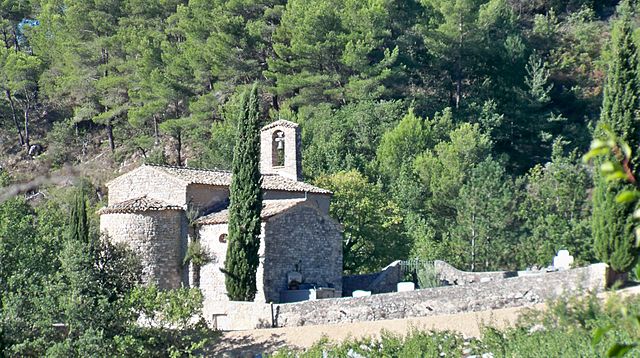
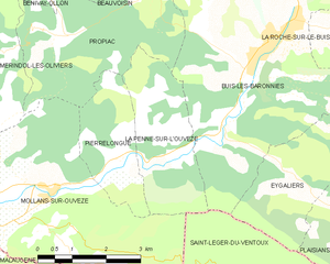
La Penne-sur-l'Ouvèze
- commune in Drôme, France
Hiking in La Penne-sur-l'Ouvèze
La Penne-sur-l'Ouvèze is a charming village located in the Vaucluse department of the Provence-Alpes-Côte d'Azur region in southeastern France. It is a fantastic destination for hiking enthusiasts, as it offers a variety of trails that cater to different skill levels and showcase the beautiful natural landscape of the region. Here are some highlights of hiking in this area:...
- Country:
- Postal Code: 26170
- Coordinates: 44° 15' 7" N, 5° 13' 42" E
- GPS tracks (wikiloc): [Link]
- Area: 7.32 sq km
- Population: 102


La Roche-sur-le-Buis
- commune in Drôme, France
Hiking in La Roche-sur-le-Buis
La Roche-sur-le-Buis is a charming commune located in the Vaucluse department of southeastern France, nestled in the scenic landscapes of the Drôme Provençale region. It’s a lesser-known destination for hikers, but it offers an array of beautiful trails and natural sites that are perfect for outdoor enthusiasts....
- Country:
- Postal Code: 26170
- Coordinates: 44° 16' 37" N, 5° 18' 44" E
- GPS tracks (wikiloc): [Link]
- Area: 27.72 sq km
- Population: 295


Sainte-Jalle
- commune in Drôme, France
Hiking in Sainte-Jalle
Sainte-Jalle is a picturesque village located in the Drôme department in the Auvergne-Rhône-Alpes region of France. The area surrounding Sainte-Jalle is known for its stunning landscapes, with rolling hills, rocky outcrops, and expansive vineyards, making it a great destination for hiking enthusiasts....
- Country:
- Postal Code: 26110
- Coordinates: 44° 20' 42" N, 5° 17' 2" E
- GPS tracks (wikiloc): [Link]
- Area: 18.16 sq km
- Population: 301


Rochebrune
- commune in Drôme, France
Hiking in Rochebrune
Rochebrune is a picturesque region located in the Drôme department of southeastern France, known for its stunning natural landscapes and diverse hiking opportunities. If you're planning to hike in Rochebrune, here are some key points to consider:...
- Country:
- Postal Code: 26110
- Coordinates: 44° 20' 13" N, 5° 14' 44" E
- GPS tracks (wikiloc): [Link]
- Area: 16.15 sq km
- Population: 61


Vercoiran
- commune in Drôme, France
Hiking in Vercoiran
Vercoiran is a charming commune located in the Drôme department in southeastern France, known for its beautiful natural landscapes and outdoor activities, including hiking. The region offers various trails that cater to different levels of hikers, from beginners to more experienced outdoor enthusiasts....
- Country:
- Postal Code: 26170
- Coordinates: 44° 18' 3" N, 5° 20' 45" E
- GPS tracks (wikiloc): [Link]
- Area: 19.95 sq km
- Population: 144


Propiac
- commune in Drôme, France
Hiking in Propiac
Propiac is a charming village located in the Drôme department of the Auvergne-Rhône-Alpes region in southeastern France. It's situated near the picturesque landscapes of the Vercors Regional Natural Park, making it an excellent base for hiking enthusiasts. Here are some important points about hiking in and around Propiac:...
- Country:
- Postal Code: 26170
- Coordinates: 44° 16' 40" N, 5° 11' 55" E
- GPS tracks (wikiloc): [Link]
- Area: 11.15 sq km
- Population: 117


Saint-Léger-du-Ventoux
- commune in Vaucluse, France
Hiking in Saint-Léger-du-Ventoux
Saint-Léger-du-Ventoux is a charming village located in the Vaucluse department of the Provence-Alpes-Côte d'Azur region in southern France, at the foot of the iconic Mont Ventoux. This area is known for its stunning landscapes, diverse flora and fauna, and excellent hiking opportunities....
- Country:
- Postal Code: 84390
- Coordinates: 44° 12' 44" N, 5° 16' 32" E
- GPS tracks (wikiloc): [Link]
- Area: 19.29 sq km
- Population: 37


Eygaliers
- commune in Drôme, France
Hiking in Eygaliers
Eygaliers is a beautiful village located in the southern part of France, in the region of Provence-Alpes-Côte d'Azur, specifically in the Drôme department. This area is known for its stunning landscapes, including rocky cliffs, lush forests, and breathtaking views of the surrounding countryside, making it a fantastic destination for hiking enthusiasts....
- Country:
- Postal Code: 26170
- Coordinates: 44° 14' 21" N, 5° 16' 48" E
- GPS tracks (wikiloc): [Link]
- Area: 8 sq km
- Population: 102


Bésignan
- commune in Drôme, France
Hiking in Bésignan
Bésignan is a small, picturesque village located in the Drôme department of southeastern France. Nestled in the foothills of the Vercors Mountains, it offers a range of beautiful hiking opportunities for outdoor enthusiasts....
- Country:
- Postal Code: 26110
- Coordinates: 44° 19' 13" N, 5° 19' 31" E
- GPS tracks (wikiloc): [Link]
- Area: 8.94 sq km
- Population: 70


Beauvoisin
- commune in Drôme, France
Hiking in Beauvoisin
Beauvoisin, located in the Drôme department of southeastern France, is a charming area that offers a variety of hiking opportunities in a picturesque countryside setting. Here are some key points about hiking in Beauvoisin and its surroundings:...
- Country:
- Postal Code: 26170
- Coordinates: 44° 18' 5" N, 5° 12' 39" E
- GPS tracks (wikiloc): [Link]
- Area: 8.9 sq km
- Population: 149