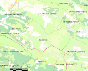
Eygaliers (Eygaliers)

- commune in Drôme, France
 Hiking in Eygaliers
Eygaliers is a beautiful village located in the southern part of France, in the region of Provence-Alpes-Côte d'Azur, specifically in the Drôme department. This area is known for its stunning landscapes, including rocky cliffs, lush forests, and breathtaking views of the surrounding countryside, making it a fantastic destination for hiking enthusiasts.
Hiking Trails
-
Les Sentiers des Crêtes: A popular trail that offers spectacular panoramic views of the surrounding hills and valleys. This route is moderate in difficulty, making it suitable for most hikers.
-
Montagne de la Lance: This hike takes you to a higher elevation, where you can enjoy views of both the Alps and the Mediterranean. The trail is well-marked and provides a nice mix of shaded areas and open vistas.
-
Le Plateau d'Aubenas: Another beautiful hike that showcases the unique flora and fauna of the region. The terrain varies from easy to moderate, making it accessible for families and experienced hikers alike.
Best Time to Hike
The best times to hike in Eygaliers are during the spring (April to June) and fall (September to October) when the weather is generally mild, and the scenery is vibrant with blooming flowers or autumn colors. Summer can be quite hot, especially in July and August, so it’s advisable to start hikes early in the morning or later in the afternoon.
Preparation and Safety
- Always carry enough water, especially if hiking in the warmer months.
- Wear sturdy hiking boots and dress in layers to accommodate varying temperatures.
- Make sure to bring a map or GPS device, as some trails may not be marked.
- Inform someone of your planned route and estimated return time.
Local Highlights
While in Eygaliers, don't miss the opportunity to explore the village and its charming architecture. You can also enjoy local cuisine and regional specialties, which can be a rewarding way to relax after a day of hiking.
Eygaliers is a hidden gem for hikers looking for stunning scenery and a peaceful environment away from the crowds. Enjoy your hiking adventure!
- Country:

- Postal Code: 26170
- Coordinates: 44° 14' 21" N, 5° 16' 48" E


- GPS tracks (wikiloc): [Link]
- Area: 8 sq km
- Population: 102
- Wikipedia en: wiki(en)
- Wikipedia: wiki(fr)
- Wikidata storage: Wikidata: Q859865
- Wikipedia Commons Category: [Link]
- Freebase ID: [/m/03mhg9s]
- GeoNames ID: Alt: [6430088]
- SIREN number: [212601272]
- BnF ID: [15252988f]
- INSEE municipality code: 26127
Shares border with regions:


La Roche-sur-le-Buis
- commune in Drôme, France
Hiking in La Roche-sur-le-Buis
La Roche-sur-le-Buis is a charming commune located in the Vaucluse department of southeastern France, nestled in the scenic landscapes of the Drôme Provençale region. It’s a lesser-known destination for hikers, but it offers an array of beautiful trails and natural sites that are perfect for outdoor enthusiasts....
- Country:
- Postal Code: 26170
- Coordinates: 44° 16' 37" N, 5° 18' 44" E
- GPS tracks (wikiloc): [Link]
- Area: 27.72 sq km
- Population: 295

Plaisians
- commune in Drôme, France
Hiking in Plaisians
Plaisians is a charming village located in the southern part of France, nestled in the picturesque region of the Vaucluse in Provence. It offers stunning landscapes, including rolling hills, vineyards, and forests, making it a fantastic destination for hiking enthusiasts....
- Country:
- Postal Code: 26170
- Coordinates: 44° 13' 45" N, 5° 19' 3" E
- GPS tracks (wikiloc): [Link]
- Area: 29.64 sq km
- Population: 195


Buis-les-Baronnies
- commune in Drôme, France
Hiking in Buis-les-Baronnies
Buis-les-Baronnies, located in the Drome department of southeastern France, is a fantastic destination for hiking enthusiasts. Nestled in the picturesque Baronnies region, the area boasts diverse landscapes, varying altitudes, and a mild Mediterranean climate, making it ideal for outdoor activities....
- Country:
- Postal Code: 26170
- Coordinates: 44° 16' 31" N, 5° 16' 28" E
- GPS tracks (wikiloc): [Link]
- Area: 33.74 sq km
- Population: 2287
- Web site: [Link]


Saint-Léger-du-Ventoux
- commune in Vaucluse, France
Hiking in Saint-Léger-du-Ventoux
Saint-Léger-du-Ventoux is a charming village located in the Vaucluse department of the Provence-Alpes-Côte d'Azur region in southern France, at the foot of the iconic Mont Ventoux. This area is known for its stunning landscapes, diverse flora and fauna, and excellent hiking opportunities....
- Country:
- Postal Code: 84390
- Coordinates: 44° 12' 44" N, 5° 16' 32" E
- GPS tracks (wikiloc): [Link]
- Area: 19.29 sq km
- Population: 37