Buvilly (Buvilly)

- commune in Jura, France
 Hiking in Buvilly
Buvilly is a lesser-known but charming destination for hiking enthusiasts. While specific information about trails may vary, here are some general tips and details that can enhance your hiking experience in the area:
-
Scenic Trails: Expect to find beautiful landscapes that showcase the natural beauty of the region. Look for trails that offer views of forests, rivers, and possibly wildlife.
-
Trail Difficulty: Be sure to check the difficulty levels of the trails available. There are usually options for beginners as well as more challenging routes for experienced hikers.
-
Seasonal Considerations: Depending on the time of year you visit, the conditions can vary greatly. Spring and autumn might offer the most pleasant weather, while summer can be hot and winter may present snow-covered paths.
-
Preparation: Always equip yourself with the appropriate gear, including good hiking boots, weather-appropriate clothing, and plenty of water. A map or GPS device can also help in navigating the trails.
-
Local Regulations: Be aware of any regulations concerning trail usage, wildlife protection, and campfires. It’s important to leave no trace and respect the natural environment.
-
Connecting with Nature: Take the opportunity to enjoy the local flora and fauna. If you’re lucky, you may spot some unique species or breathtaking views along the trails.
-
Safety First: Always inform someone of your hiking plans or consider hiking with a group. Check the weather forecast before you head out and be prepared for sudden changes.
If you have specific trails or areas in Buvilly you’d like more detailed information on, I’d be happy to help!
- Country:

- Postal Code: 39800
- Coordinates: 46° 52' 5" N, 5° 43' 10" E


- GPS tracks (wikiloc): [Link]
- Area: 6 sq km
- Population: 388
- Wikipedia en: wiki(en)
- Wikipedia: wiki(fr)
- Wikidata storage: Wikidata: Q938822
- Wikipedia Commons Category: [Link]
- Freebase ID: [/m/03nnz97]
- GeoNames ID: Alt: [6448810]
- SIREN number: [213900814]
- BnF ID: [152584457]
- VIAF ID: Alt: [239196787]
- INSEE municipality code: 39081
Shares border with regions:

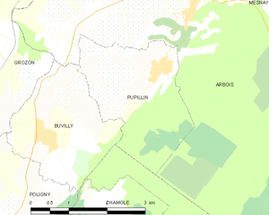
Pupillin
- commune in Jura, France
Hiking in Pupillin
Pupillin is a charming village located in the Jura region of France, well-known for its picturesque landscapes, vineyards, and opportunities for outdoor activities, including hiking. Here are some highlights of hiking in and around Pupillin:...
- Country:
- Postal Code: 39600
- Coordinates: 46° 53' 0" N, 5° 45' 39" E
- GPS tracks (wikiloc): [Link]
- Area: 6.61 sq km
- Population: 242
- Web site: [Link]

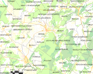
Arbois
- commune in Jura, France
Hiking in Arbois
Arbois, located in the Jura region of France, is a picturesque town nestled in the vineyards and hills of the Jura Mountains. Known for its wine production, particularly the Vin Jaune, Arbois also offers fantastic hiking opportunities for outdoor enthusiasts....
- Country:
- Postal Code: 39600
- Coordinates: 46° 54' 10" N, 5° 46' 26" E
- GPS tracks (wikiloc): [Link]
- Area: 45.42 sq km
- Population: 3407
- Web site: [Link]


Poligny
- commune in Jura, France
Hiking in Poligny
Poligny, located in the Jura region of France, is a charming town surrounded by beautiful natural landscapes which make it a fantastic destination for hiking enthusiasts. Here are some key points to know about hiking in this area:...
- Country:
- Postal Code: 39800
- Coordinates: 46° 50' 10" N, 5° 42' 28" E
- GPS tracks (wikiloc): [Link]
- Area: 50.22 sq km
- Population: 4104
- Web site: [Link]


Grozon
- commune in Jura, France
Hiking in Grozon
It seems you may be referring to "Grosmont" or perhaps a similar-sounding location as "Grozon" may not be widely recognized as a hiking destination. If you're thinking of Grosmont, which is a village in North Yorkshire, England, I can provide information on that or other well-known hiking spots....
- Country:
- Postal Code: 39800
- Coordinates: 46° 53' 23" N, 5° 42' 3" E
- GPS tracks (wikiloc): [Link]
- Area: 14.25 sq km
- Population: 436