Cézia (Cézia)

- commune in Jura, France
 Hiking in Cézia
As of my last update, there's no widely recognized location known as "Cézia" in hiking literature or guides. It’s possible that it could refer to a lesser-known area, a local nickname, or perhaps a typographical error. If you meant a specific region or park and can clarify or provide additional context, I would be more than happy to help!
If you’re looking into hiking in a specific region or country, I can provide insights on popular trails, tips, safety recommendations, and gear suggestions. Please share more details so I can assist you better!
- Country:

- Postal Code: 39240
- Coordinates: 46° 21' 37" N, 5° 34' 29" E


- GPS tracks (wikiloc): [Link]
- Area: 3.6 sq km
- Population: 69
- Wikipedia en: wiki(en)
- Wikipedia: wiki(fr)
- Wikidata storage: Wikidata: Q1142138
- Wikipedia Commons Category: [Link]
- Freebase ID: [/m/03np27l]
- GeoNames ID: Alt: [6448815]
- SIREN number: [213900897]
- INSEE municipality code: 39089
Shares border with regions:

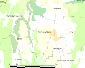
Saint-Hymetière
- commune in Jura, France
Hiking in Saint-Hymetière
Saint-Hymetière, located in France, offers a range of hiking opportunities that cater to different skill levels and preferences. The surrounding natural landscapes include lush forests, rolling hills, and panoramic views that are perfect for outdoor enthusiasts....
- Country:
- Postal Code: 39240
- Coordinates: 46° 21' 32" N, 5° 33' 37" E
- GPS tracks (wikiloc): [Link]
- Area: 3.32 sq km
- Population: 107


Lavans-sur-Valouse
- commune in Jura, France
Hiking in Lavans-sur-Valouse
Lavans-sur-Valouse is a charming commune located in the Jura department of France. Nestled in the picturesque landscapes of the Jura Mountains, it offers a variety of hiking options that cater to different skill levels. Here's what you can expect when hiking in and around Lavans-sur-Valouse:...
- Country:
- Postal Code: 39240
- Coordinates: 46° 20' 30" N, 5° 33' 53" E
- GPS tracks (wikiloc): [Link]
- Area: 9.51 sq km
- Population: 146


Chemilla
- commune in Jura, France
Hiking in Chemilla
Chemilla, located in the region of the Basque Country in Spain, offers beautiful landscapes and diverse hiking opportunities. Here are some key points to consider for hiking in Chemilla:...
- Country:
- Postal Code: 39240
- Coordinates: 46° 21' 26" N, 5° 33' 36" E
- GPS tracks (wikiloc): [Link]
- Area: 1.87 sq km
- Population: 111


Chisséria
- former commune in Jura, France
Hiking in Chisséria
Chisséria, often referred to as a hidden gem for outdoor enthusiasts, offers a variety of hiking trails that cater to different skill levels and provide stunning landscapes. While specific trail names and detailed mapping can vary, here are some general highlights and tips for hiking in the Chisséria region:...
- Country:
- Postal Code: 39240
- Coordinates: 46° 22' 46" N, 5° 33' 47" E
- GPS tracks (wikiloc): [Link]
- Area: 7.25 sq km
- Population: 72