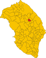
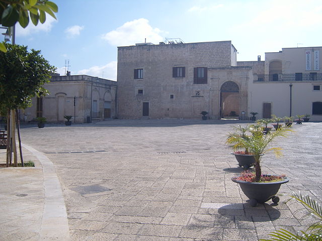
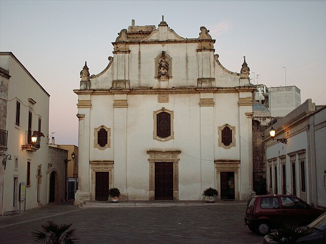
Calimera (Calimera)
.svg)
- Italian comune
 Hiking in Calimera
Calimera, located in the Salento region of Italy, is known for its beautiful landscapes, rich history, and vibrant local culture. While it may not be as famous as some larger hiking destinations, it offers several opportunities for outdoor enthusiasts. Here are a few highlights for hiking in and around Calimera:
Trails and Areas to Explore
-
Local Nature Trails: Surrounding Calimera, you'll find paths that wind through olive groves, vineyards, and rural landscapes. These trails can be quite picturesque, especially in spring and early fall when the flora is abundant.
-
Coastal Hikes: The nearby Ionian and Adriatic coasts offer stunning coastal cliffs and beaches. The coastal path from Calimera to nearby towns like Otranto or Santa Cesarea Terme provides breathtaking views of the coastline.
-
Caves and Grottos: Explore the nearby natural caves, such as those found in the Grotta della Poesia, where you can hike and enjoy swimming in the crystal-clear waters.
-
Regional Parks: Consider visiting the nearby Regional Natural Park of Porto Selvaggio, which combines both natural beauty and opportunities for hiking. The park features a variety of trails that showcase the local flora and fauna, as well as stunning coastal views.
Tips for Hiking in Calimera
-
Best Time to Hike: Spring and fall are ideal times for hiking, with moderate temperatures and blooming flora. Summer can be quite hot, so early morning or late afternoon hikes are recommended.
-
Stay Hydrated: Always carry sufficient water, especially during warmer months. While there are plenty of scenic spots for breaks, hydration is essential.
-
Respect Local Wildlife: Be mindful of the local wildlife and natural habitats. Staying on marked trails helps protect the local environment.
-
Check Weather Conditions: Weather can change, especially near the coast, so check the forecast before heading out and dress appropriately.
-
Local Guides: If you're unfamiliar with the area or prefer guided hikes, consider hiring a local guide. They can provide insights into the local history, flora, fauna, and hidden spots.
Overall, hiking in Calimera and the surrounding areas can be a delightful experience filled with natural beauty and cultural enrichment. Whether you're looking for leisurely walks or more challenging hikes, there's something for everyone in this charming part of Italy.
- Country:

- Postal Code: 73021
- Local Dialing Code: 0832
- Licence Plate Code: LE
- Coordinates: 40° 14' 58" N, 18° 16' 47" E


- GPS tracks (wikiloc): [Link]
- AboveSeaLevel: 56 м m
- Area: 11.18 sq km
- Population: 7009
- Web site: http://www.comune.calimera.le.it
- Wikipedia en: wiki(en)
- Wikipedia: wiki(it)
- Wikidata storage: Wikidata: Q52118
- Wikipedia Commons Category: [Link]
- Freebase ID: [/m/03wk5h]
- GeoNames ID: Alt: [6539837]
- VIAF ID: Alt: [238117510]
- OSM relation ID: [40360]
- MusicBrainz area ID: [39972a06-4148-4e57-ae57-1bf04d41d053]
- Digital Atlas of the Roman Empire ID: [42159]
- ISTAT ID: 075010
- Italian cadastre code: B413
Shares border with regions:

Caprarica di Lecce
- Italian comune
Hiking in Caprarica di Lecce
Caprarica di Lecce is a charming town located in the Salento region of Puglia, Italy. While it may not be as well-known for hiking as some other areas, it can serve as a great starting point for exploring the surrounding countryside and coastal areas. Here’s some information and tips for hiking in and around Caprarica di Lecce:...
- Country:
- Postal Code: 73010
- Local Dialing Code: 0832
- Licence Plate Code: LE
- Coordinates: 40° 16' 0" N, 18° 15' 0" E
- GPS tracks (wikiloc): [Link]
- AboveSeaLevel: 60 м m
- Area: 10.71 sq km
- Population: 2411
- Web site: [Link]


Carpignano Salentino
- Italian comune
Hiking in Carpignano Salentino
Carpignano Salentino is a charming village located in the Apulia region of Italy, known for its scenic beauty and rich cultural heritage. Hiking in this area offers a wonderful opportunity to experience the picturesque landscapes, traditional stone architecture, and the stunning Mediterranean coastline....
- Country:
- Postal Code: 73020
- Local Dialing Code: 0836
- Licence Plate Code: LE
- Coordinates: 40° 11' 49" N, 18° 20' 18" E
- GPS tracks (wikiloc): [Link]
- AboveSeaLevel: 76 м m
- Area: 48.99 sq km
- Population: 3753
- Web site: [Link]

Castri di Lecce
- Italian comune
Hiking in Castri di Lecce
Castri di Lecce is a charming village located in the Apulia region of Italy, known for its scenic beauty and historical significance. While the area is not primarily recognized as a hiking hotspot like some national parks, there are a few trails and natural spots that you can explore around Castri di Lecce. Here are some tips and insights for hiking in and around the area:...
- Country:
- Postal Code: 73020
- Local Dialing Code: 0832
- Licence Plate Code: LE
- Coordinates: 40° 16' 0" N, 18° 16' 0" E
- GPS tracks (wikiloc): [Link]
- AboveSeaLevel: 47 м m
- Area: 12.95 sq km
- Population: 2904
- Web site: [Link]

Martano
- Italian comune
Hiking in Martano
Martano is a small town located in the Apulia region of Italy, known for its rich history, agriculture, and proximity to natural landscapes. While Martano itself is not primarily famous for hiking trails, there are several opportunities for outdoor enthusiasts in the surrounding areas....
- Country:
- Postal Code: 73025
- Local Dialing Code: 0836
- Licence Plate Code: LE
- Coordinates: 40° 12' 0" N, 18° 18' 0" E
- GPS tracks (wikiloc): [Link]
- AboveSeaLevel: 92 м m
- Area: 22.25 sq km
- Population: 9087
- Web site: [Link]

Martignano
- Italian comune
Hiking in Martignano
Martignano, located in the Italian region of Lazio, is known for its beautiful landscapes and natural parks, making it an excellent destination for hiking enthusiasts. The area is characterized by rolling hills, lush forests, and the stunning views of Lake Martignano, a volcanic lake surrounded by greenery....
- Country:
- Postal Code: 73020
- Local Dialing Code: 0832
- Licence Plate Code: LE
- Coordinates: 40° 14' 18" N, 18° 15' 22" E
- GPS tracks (wikiloc): [Link]
- AboveSeaLevel: 99 м m
- Area: 6.49 sq km
- Population: 1665
- Web site: [Link]
Melendugno
- Italian comune
Hiking in Melendugno
Melendugno is a beautiful coastal town located in the Puglia region of Italy, known for its stunning landscapes, crystal-clear waters, and charming historical sites. While it's primarily famous for its beaches, such as those at Torre dell'Orso and San Foca, there are also opportunities for hiking and exploring nature in and around the area. Here are some highlights for hiking in Melendugno and its surroundings:...
- Country:
- Postal Code: 73026
- Local Dialing Code: 0832
- Licence Plate Code: LE
- Coordinates: 40° 16' 0" N, 18° 20' 0" E
- GPS tracks (wikiloc): [Link]
- AboveSeaLevel: 36 м m
- Area: 92.31 sq km
- Population: 9999
- Web site: [Link]


Vernole
- Italian comune
Hiking in Vernole
Vernole, located in the Apulia region of Italy, is not as widely known for hiking as some other areas, but it offers opportunities to explore its beautiful landscapes, historical sites, and coastal views. Here are some highlights and tips for hiking in and around Vernole:...
- Country:
- Postal Code: 73029
- Local Dialing Code: 0832
- Licence Plate Code: LE
- Coordinates: 40° 17' 0" N, 18° 18' 0" E
- GPS tracks (wikiloc): [Link]
- AboveSeaLevel: 38 м m
- Area: 61.28 sq km
- Population: 7062
- Web site: [Link]
Zollino
- Italian comune
Hiking in Zollino
Zollino, a charming town located in the Apulia region of southern Italy, offers a unique experience for hikers looking to explore natural landscapes and cultural heritage. Here are some key points about hiking in and around Zollino:...
- Country:
- Postal Code: 73010
- Local Dialing Code: 0836
- Licence Plate Code: LE
- Coordinates: 40° 12' 0" N, 18° 15' 0" E
- GPS tracks (wikiloc): [Link]
- AboveSeaLevel: 90 м m
- Area: 9.95 sq km
- Population: 1961
- Web site: [Link]