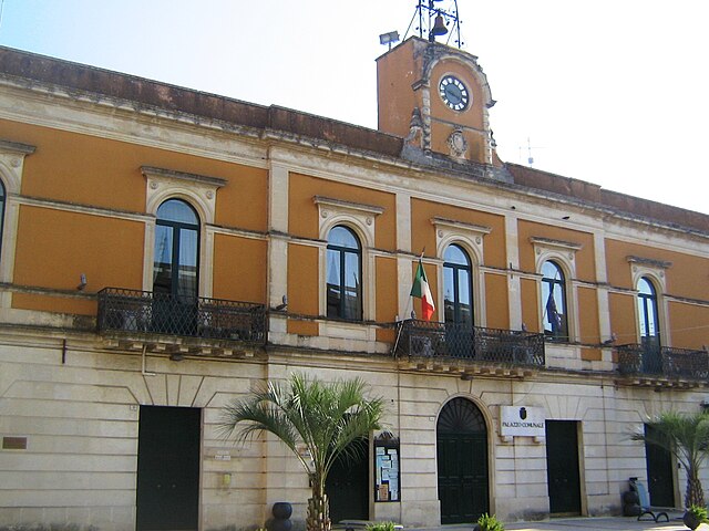
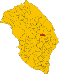
Martano (Martano)
- Italian comune
 Hiking in Martano
Martano is a small town located in the Apulia region of Italy, known for its rich history, agriculture, and proximity to natural landscapes. While Martano itself is not primarily famous for hiking trails, there are several opportunities for outdoor enthusiasts in the surrounding areas.
Hiking Opportunities Near Martano
-
Serra di Galugnano: Located a short drive from Martano, this area offers picturesque trails through wooded hills and along rocky outcrops. The flora and fauna here are typical of the Mediterranean ecosystem, making for a lovely day hike.
-
Laghi Alimini: This natural reserve features beautiful lakes and coastal areas. The region offers several trails where you can walk through dense vegetation, explore the wetlands, and even enjoy some birdwatching.
-
Otranto Coastal Path: A bit further away, the coastal paths near Otranto provide breathtaking views of the Adriatic Sea. The trails along the coastline offer varying difficulty levels, and you can enjoy the stunning landscapes of cliffs, beaches, and turquoise waters.
-
Parco Naturale Regionale Costa Otranto-Santa Maria di Leuca: This regional park, located not far from Martano, features rugged coastline, diverse flora and fauna, and numerous hiking trails. It's an excellent place for more adventurous hikers looking to explore nature.
Tips for Hiking in Martano
- Best Time to Hike: Spring (April to June) and autumn (September to October) are ideal for hiking in this region due to milder temperatures and less crowded trails.
- What to Bring: Ensure you have plenty of water, snacks, sun protection (like sunscreen and hats), appropriate footwear, and a first-aid kit.
- Local Guides: Consider hiring a local hiking guide for a more enriching experience, especially if you're unfamiliar with the area.
- Respect Nature: Always follow Leave No Trace principles—take everything with you, stay on marked trails, and avoid disturbing wildlife.
Overall, while Martano may not have abundant direct hiking trails, its location allows easy access to several beautiful hiking areas, making it a great base for exploring the natural beauty of the Apulia region.
- Country:

- Postal Code: 73025
- Local Dialing Code: 0836
- Licence Plate Code: LE
- Coordinates: 40° 12' 0" N, 18° 18' 0" E


- GPS tracks (wikiloc): [Link]
- AboveSeaLevel: 92 м m
- Area: 22.25 sq km
- Population: 9087
- Web site: http://www.comune.martano.le.it
- Wikipedia en: wiki(en)
- Wikipedia: wiki(it)
- Wikidata storage: Wikidata: Q52154
- Wikipedia Commons Category: [Link]
- Freebase ID: [/m/03wkd0]
- GeoNames ID: Alt: [6538973]
- VIAF ID: Alt: [123992420]
- UN/LOCODE: [ITZOD]
- ISTAT ID: 075040
- Italian cadastre code: E979
Shares border with regions:

Calimera
- Italian comune
Hiking in Calimera
Calimera, located in the Salento region of Italy, is known for its beautiful landscapes, rich history, and vibrant local culture. While it may not be as famous as some larger hiking destinations, it offers several opportunities for outdoor enthusiasts. Here are a few highlights for hiking in and around Calimera:...
- Country:
- Postal Code: 73021
- Local Dialing Code: 0832
- Licence Plate Code: LE
- Coordinates: 40° 14' 58" N, 18° 16' 47" E
- GPS tracks (wikiloc): [Link]
- AboveSeaLevel: 56 м m
- Area: 11.18 sq km
- Population: 7009
- Web site: [Link]


Carpignano Salentino
- Italian comune
Hiking in Carpignano Salentino
Carpignano Salentino is a charming village located in the Apulia region of Italy, known for its scenic beauty and rich cultural heritage. Hiking in this area offers a wonderful opportunity to experience the picturesque landscapes, traditional stone architecture, and the stunning Mediterranean coastline....
- Country:
- Postal Code: 73020
- Local Dialing Code: 0836
- Licence Plate Code: LE
- Coordinates: 40° 11' 49" N, 18° 20' 18" E
- GPS tracks (wikiloc): [Link]
- AboveSeaLevel: 76 м m
- Area: 48.99 sq km
- Population: 3753
- Web site: [Link]

Castrignano de' Greci
- Italian comune
Hiking in Castrignano de' Greci
Castrignano de' Greci is a small town located in the Apulia region of southern Italy, known for its charming historical architecture and beautiful natural surroundings. While it may not be as famous as some other hiking destinations in Italy, it offers some lovely opportunities for hiking enthusiasts....
- Country:
- Postal Code: 73020
- Local Dialing Code: 0836
- Licence Plate Code: LE
- Coordinates: 40° 12' 0" N, 18° 18' 0" E
- GPS tracks (wikiloc): [Link]
- AboveSeaLevel: 90 м m
- Area: 9.62 sq km
- Population: 3919
- Web site: [Link]


Corigliano d'Otranto
- Italian comune
Hiking in Corigliano d'Otranto
Corigliano d'Otranto, located in the province of Lecce in the Apulia region of Italy, offers a charming landscape that is perfect for hiking enthusiasts. While it may not be the first location that comes to mind for hiking, it does have unique features that attract nature lovers and adventurers alike....
- Country:
- Postal Code: 73022
- Local Dialing Code: 0836
- Licence Plate Code: LE
- Coordinates: 40° 10' 0" N, 18° 15' 0" E
- GPS tracks (wikiloc): [Link]
- AboveSeaLevel: 76 м m
- Area: 28.41 sq km
- Population: 5768
- Web site: [Link]

Martignano
- Italian comune
Hiking in Martignano
Martignano, located in the Italian region of Lazio, is known for its beautiful landscapes and natural parks, making it an excellent destination for hiking enthusiasts. The area is characterized by rolling hills, lush forests, and the stunning views of Lake Martignano, a volcanic lake surrounded by greenery....
- Country:
- Postal Code: 73020
- Local Dialing Code: 0832
- Licence Plate Code: LE
- Coordinates: 40° 14' 18" N, 18° 15' 22" E
- GPS tracks (wikiloc): [Link]
- AboveSeaLevel: 99 м m
- Area: 6.49 sq km
- Population: 1665
- Web site: [Link]
Zollino
- Italian comune
Hiking in Zollino
Zollino, a charming town located in the Apulia region of southern Italy, offers a unique experience for hikers looking to explore natural landscapes and cultural heritage. Here are some key points about hiking in and around Zollino:...
- Country:
- Postal Code: 73010
- Local Dialing Code: 0836
- Licence Plate Code: LE
- Coordinates: 40° 12' 0" N, 18° 15' 0" E
- GPS tracks (wikiloc): [Link]
- AboveSeaLevel: 90 м m
- Area: 9.95 sq km
- Population: 1961
- Web site: [Link]