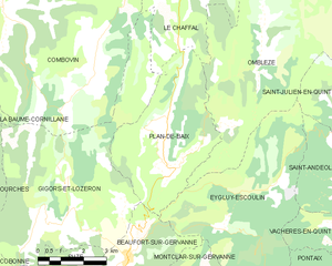
canton of Crest-Nord (canton de Crest-Nord)
- canton of France
 Hiking in canton of Crest-Nord
Canton de Crest-Nord, located in the Drôme department of southeastern France, is known for its beautiful landscapes and varied hiking opportunities. The region is characterized by its picturesque valleys, rolling hills, and stunning views of the Vercors and Diois mountains. Here are some key points about hiking in this region:
Trails and Routes
-
Variety of Trails: There are numerous hiking trails suitable for all skill levels, from easy walks to challenging hikes. The trails often lead you through forests, open fields, and along rivers.
-
GR Routes: The area is part of the Grande Randonnée (GR) network, which offers long-distance hiking opportunities. The GR 9 is one such trail that traverses the region, connecting various villages and providing scenic views.
-
Local Hiking Guides: Many local guides and organizations offer guided hikes that showcase the natural beauty and rich heritage of the area. They can provide insights into the local flora and fauna, as well as historical sites.
Key Attractions
-
Views: Many trails offer breathtaking views of the surrounding mountains, valleys, and vineyards, making for memorable hiking experiences and perfect photo opportunities.
-
Natural Sites: Explore the local natural parks and protected areas, which are home to a variety of wildlife and plant species. The diverse ecosystems provide a beautiful backdrop for any hike.
-
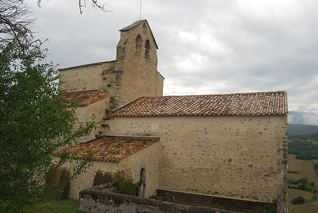
Cultural Heritage: The region is rich in history, and some hikes will take you past old farms, churches, and ruins that are worth exploring.
Tips for Hiking in Canton de Crest-Nord
- Plan Ahead: Check trail conditions, as some paths can be more challenging after rain.
- Pack Essentials: Bring sufficient water, snacks, a map or GPS device, and appropriate clothing for changing weather conditions.
- Respect Nature: Follow the Leave No Trace principles to preserve the beauty of the area and its biodiversity.
- Local Regulations: Be aware of any local regulations regarding hiking, especially in protected areas or during certain seasons.
Seasons
- Spring: A great time to hike, with wildflowers blooming and moderate temperatures.
- Summer: Warm weather makes for enjoyable hiking, but be prepared for sunny conditions and possibly crowded trails.
- Autumn: The changing foliage offers stunning views, and cooler temperatures make hiking comfortable.
- Winter: Some trails may be accessible for snowshoeing or winter hiking, but proper gear is essential.
Hiking in Canton de Crest-Nord allows for a blend of adventure, nature, and cultural discovery, making it an excellent destination for outdoor enthusiasts.
- Country:

- Capital: Crest
- Coordinates: 44° 44' 5" N, 5° 3' 25" E


- GPS tracks (wikiloc): [Link]
- Wikidata storage: Wikidata: Q1725100
- INSEE canton code: [2607]
Includes regions:


Ourches
- commune in Drôme, France
Hiking in Ourches
Ourches is a lesser-known location for hiking, and detailed information about specific trails may be limited. However, if you are referring to a specific area or region (such as Ourches in France), I'd recommend looking for local hiking resources as well as national park guidance if applicable....
- Country:
- Postal Code: 26120
- Coordinates: 44° 48' 17" N, 5° 2' 29" E
- GPS tracks (wikiloc): [Link]
- Area: 9.23 sq km
- Population: 247

Plan-de-Baix
- commune in Drôme, France
Hiking in Plan-de-Baix
Plan-de-Baix is a picturesque village located in the Drôme department of the Auvergne-Rhône-Alpes region in southeastern France. The surrounding area offers a variety of hiking opportunities, showcasing beautiful landscapes, diverse flora and fauna, and cultural heritage. Here are some highlights for hiking in and around Plan-de-Baix:...
- Country:
- Postal Code: 26400
- Coordinates: 44° 48' 45" N, 5° 9' 57" E
- GPS tracks (wikiloc): [Link]
- Area: 19.39 sq km
- Population: 137

Vaunaveys-la-Rochette
- commune in Drôme, France
Hiking in Vaunaveys-la-Rochette
Vaunaveys-la-Rochette, located in the Auvergne-Rhône-Alpes region of France, offers a fantastic environment for hiking enthusiasts. The village is perched in the foothills of the French Alps, providing hikers with access to stunning landscapes, diverse terrain, and a variety of trails suitable for different skill levels....
- Country:
- Postal Code: 26400
- Coordinates: 44° 46' 5" N, 5° 1' 58" E
- GPS tracks (wikiloc): [Link]
- Area: 21.93 sq km
- Population: 592


Suze
- commune in Drôme, France
Hiking in Suze
Suze is a charming village located in the Drôme department of the Auvergne-Rhône-Alpes region in southeastern France. The area is known for its stunning landscapes, historical sites, and great hiking opportunities. Here are some highlights of hiking in and around Suze:...
- Country:
- Postal Code: 26400
- Coordinates: 44° 45' 34" N, 5° 6' 46" E
- GPS tracks (wikiloc): [Link]
- Area: 14.43 sq km
- Population: 232

Mirabel-et-Blacons
- commune in Drôme, France
Hiking in Mirabel-et-Blacons
Mirabel-et-Blacons is a charming commune located in the Drôme department of the Auvergne-Rhône-Alpes region in southeastern France. It offers a variety of hiking opportunities, surrounded by stunning natural landscapes and diverse topography....
- Country:
- Postal Code: 26400
- Coordinates: 44° 42' 38" N, 5° 5' 31" E
- GPS tracks (wikiloc): [Link]
- Area: 17.48 sq km
- Population: 1031


Beaufort-sur-Gervanne
- commune in Drôme, France
Hiking in Beaufort-sur-Gervanne
Beaufort-sur-Gervanne is a charming commune located in the Drôme department of southeastern France. Nestled in the picturesque landscape of the French Alps, it offers numerous opportunities for hiking enthusiasts, with trails that vary in difficulty and showcase stunning natural beauty....
- Country:
- Postal Code: 26400
- Coordinates: 44° 46' 41" N, 5° 8' 33" E
- GPS tracks (wikiloc): [Link]
- Area: 9.48 sq km
- Population: 466


Eurre
- commune in Drôme, France
Hiking in Eurre
Eurre is a charming small village located in the Drôme department in southeastern France. It's surrounded by a stunning natural landscape, making it an excellent destination for hiking enthusiasts. Here are some key points about hiking in and around Eurre:...
- Country:
- Postal Code: 26400
- Coordinates: 44° 45' 34" N, 4° 59' 19" E
- GPS tracks (wikiloc): [Link]
- Area: 18.06 sq km
- Population: 1280

Montoison
- commune in Drôme, France
Hiking in Montoison
Montoison, located in the Drôme department of France, is a picturesque area that offers various opportunities for hiking enthusiasts. The region is characterized by its stunning natural landscapes, including rolling hills, vineyards, and serene countryside, making it an ideal spot for both leisurely walks and more challenging hikes....
- Country:
- Postal Code: 26800
- Coordinates: 44° 47' 52" N, 4° 56' 25" E
- GPS tracks (wikiloc): [Link]
- Area: 16.11 sq km
- Population: 1908


Omblèze
- commune in Drôme, France
Hiking in Omblèze
Omblèze is a picturesque destination located in the Drôme region of southeastern France, known for its stunning landscapes, diverse flora, and fauna, as well as its excellent hiking trails. Here are some key points about hiking in Omblèze:...
- Country:
- Postal Code: 26400
- Coordinates: 44° 51' 8" N, 5° 13' 7" E
- GPS tracks (wikiloc): [Link]
- Area: 44.92 sq km
- Population: 70

Montclar-sur-Gervanne
- commune in Drôme, France
Hiking in Montclar-sur-Gervanne
Montclar-sur-Gervanne is a picturesque commune located in the Drôme department in the Auvergne-Rhône-Alpes region of southeastern France. The area is known for its stunning natural beauty, making it a great destination for hiking enthusiasts....
- Country:
- Postal Code: 26400
- Coordinates: 44° 44' 50" N, 5° 8' 37" E
- GPS tracks (wikiloc): [Link]
- Area: 29.63 sq km
- Population: 180


Gigors-et-Lozeron
- commune in Drôme, France
Hiking in Gigors-et-Lozeron
Gigors-et-Lozeron is a beautiful commune located in the Auvergne-Rhône-Alpes region of France, nestled in the picturesque landscape of the French Alps. While it's a relatively small area, its proximity to larger mountain ranges and natural parks offers excellent hiking opportunities for outdoor enthusiasts....
- Country:
- Postal Code: 26400
- Coordinates: 44° 47' 38" N, 5° 6' 29" E
- GPS tracks (wikiloc): [Link]
- Area: 35.27 sq km
- Population: 163


Allex
- commune in Drôme, France
Hiking in Allex
Allex is not particularly well-known for hiking, as it is a small commune in the Drôme department in southeastern France. However, the surrounding region may offer some beautiful walking and hiking opportunities, particularly in the nearby hills and valleys of the Drôme Provençale....
- Country:
- Postal Code: 26400
- Coordinates: 44° 45' 50" N, 4° 55' 0" E
- GPS tracks (wikiloc): [Link]
- Area: 20.17 sq km
- Population: 2474
Aouste-sur-Sye
- commune in Drôme, France
Hiking in Aouste-sur-Sye
Aouste-sur-Sye is a charming commune located in the Drôme department of southeastern France. It offers picturesque landscapes and a variety of hiking opportunities, suitable for both beginners and experienced hikers. Here are some details about hiking in and around Aouste-sur-Sye:...
- Country:
- Postal Code: 26400
- Coordinates: 44° 42' 57" N, 5° 3' 25" E
- GPS tracks (wikiloc): [Link]
- Area: 17.98 sq km
- Population: 2465

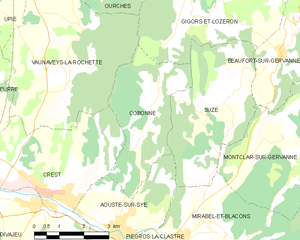
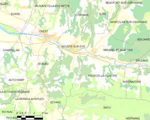
Cobonne
- commune in Drôme, France
Hiking in Cobonne
Cobonne, located in the Drôme department of France, is a charming area known for its natural beauty and outdoor activities, including hiking. Here are some highlights for hiking in and around Cobonne:...
- Country:
- Postal Code: 26400
- Coordinates: 44° 45' 34" N, 5° 4' 30" E
- GPS tracks (wikiloc): [Link]
- Area: 11.2 sq km
- Population: 164