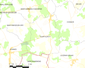
canton of Dornes (canton de Dornes)
- canton of France (until March 2015)
- Country:

- Capital: Dornes
- Coordinates: 46° 44' 6" N, 3° 22' 42" E


- GPS tracks (wikiloc): [Link]
- Wikidata storage: Wikidata: Q1372135
- INSEE canton code: [5810]
Includes regions:


Lucenay-lès-Aix
- commune in Nièvre, France
- Country:
- Postal Code: 58380
- Coordinates: 46° 42' 13" N, 3° 29' 2" E
- GPS tracks (wikiloc): [Link]
- Area: 55.05 sq km
- Population: 987


Tresnay
- commune in Nièvre, France
- Country:
- Postal Code: 58240
- Coordinates: 46° 41' 49" N, 3° 11' 14" E
- GPS tracks (wikiloc): [Link]
- Area: 18.15 sq km
- Population: 165

Toury-Lurcy
- commune in Nièvre, France
- Country:
- Postal Code: 58300
- Coordinates: 46° 44' 19" N, 3° 25' 31" E
- GPS tracks (wikiloc): [Link]
- Area: 25.54 sq km
- Population: 418
Toury-sur-Jour
- commune in Nièvre, France
- Country:
- Postal Code: 58240
- Coordinates: 46° 43' 44" N, 3° 14' 27" E
- GPS tracks (wikiloc): [Link]
- Area: 24.4 sq km
- Population: 121


Dornes
- commune in Nièvre, France
- Country:
- Postal Code: 58390
- Coordinates: 46° 42' 54" N, 3° 21' 9" E
- GPS tracks (wikiloc): [Link]
- Area: 39.49 sq km
- Population: 1393
- Web site: [Link]
Saint-Parize-en-Viry
- commune in Nièvre, France
- Country:
- Postal Code: 58300
- Coordinates: 46° 45' 8" N, 3° 21' 27" E
- GPS tracks (wikiloc): [Link]
- Area: 15.51 sq km
- Population: 163
Neuville-lès-Decize
- commune in Nièvre, France
- Country:
- Postal Code: 58300
- Coordinates: 46° 46' 13" N, 3° 18' 55" E
- GPS tracks (wikiloc): [Link]
- Area: 26.74 sq km
- Population: 247
Lamenay-sur-Loire
- commune in Nièvre, France
- Country:
- Postal Code: 58300
- Coordinates: 46° 45' 43" N, 3° 33' 44" E
- GPS tracks (wikiloc): [Link]
- Area: 11.53 sq km
- Population: 52

Cossaye
- commune in Nièvre, France
- Country:
- Postal Code: 58300
- Coordinates: 46° 44' 55" N, 3° 29' 4" E
- GPS tracks (wikiloc): [Link]
- Area: 51.17 sq km
- Population: 742