canton of Ferrières-en-Gâtinais (canton de Ferrières-en-Gâtinais)
- canton of France (until March 2015)
- Country:

- Capital: Ferrières-en-Gâtinais
- Coordinates: 48° 5' 46" N, 2° 43' 27" E


- GPS tracks (wikiloc): [Link]
- Wikidata storage: Wikidata: Q1405947
- INSEE canton code: [4512]
Includes regions:

Le Bignon-Mirabeau
- commune in Loiret, France
- Country:
- Postal Code: 45210
- Coordinates: 48° 8' 53" N, 2° 55' 22" E
- GPS tracks (wikiloc): [Link]
- Area: 12.83 sq km
- Population: 324
- Web site: [Link]


Fontenay-sur-Loing
- commune in Loiret, France
- Country:
- Postal Code: 45210
- Coordinates: 48° 6' 15" N, 2° 46' 27" E
- GPS tracks (wikiloc): [Link]
- Area: 9.73 sq km
- Population: 1730
- Web site: [Link]


Corbeilles
- commune in Loiret, France
- Country:
- Postal Code: 45490
- Coordinates: 48° 4' 20" N, 2° 32' 57" E
- GPS tracks (wikiloc): [Link]
- Area: 32.62 sq km
- Population: 1544
- Web site: [Link]

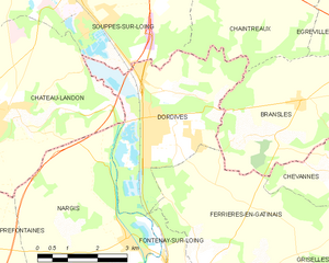
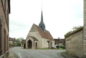
Dordives
- commune in Loiret, France
- Country:
- Postal Code: 45680
- Coordinates: 48° 8' 36" N, 2° 46' 2" E
- GPS tracks (wikiloc): [Link]
- Area: 15.18 sq km
- Population: 3301
- Web site: [Link]
Courtempierre
- commune in Loiret, France
- Country:
- Postal Code: 45490
- Coordinates: 48° 6' 11" N, 2° 36' 51" E
- GPS tracks (wikiloc): [Link]
- Area: 13.3 sq km
- Population: 236
Gondreville
- commune in Loiret, France
- Country:
- Postal Code: 45490
- Coordinates: 48° 3' 3" N, 2° 39' 17" E
- GPS tracks (wikiloc): [Link]
- AboveSeaLevel: 242 м m
- Area: 8.07 sq km
- Population: 350


Préfontaines
- commune in Loiret, France
- Country:
- Postal Code: 45490
- Coordinates: 48° 6' 31" N, 2° 41' 29" E
- GPS tracks (wikiloc): [Link]
- Area: 11.75 sq km
- Population: 452
Treilles-en-Gâtinais
- commune in Loiret, France
- Country:
- Postal Code: 45490
- Coordinates: 48° 4' 43" N, 2° 39' 35" E
- GPS tracks (wikiloc): [Link]
- Area: 13.97 sq km
- Population: 279


Sceaux-du-Gâtinais
- commune in Loiret, France
- Country:
- Postal Code: 45490
- Coordinates: 48° 6' 19" N, 2° 35' 48" E
- GPS tracks (wikiloc): [Link]
- Area: 31.72 sq km
- Population: 642

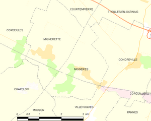
Mignères
- commune in Loiret, France
- Country:
- Postal Code: 45490
- Coordinates: 48° 2' 47" N, 2° 37' 30" E
- GPS tracks (wikiloc): [Link]
- Area: 5.12 sq km
- Population: 314


Mignerette
- commune in Loiret, France
- Country:
- Postal Code: 45490
- Coordinates: 48° 3' 18" N, 2° 36' 2" E
- GPS tracks (wikiloc): [Link]
- Area: 6.21 sq km
- Population: 388

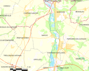
Nargis
- commune in Loiret, France
- Country:
- Postal Code: 45210
- Coordinates: 48° 6' 39" N, 2° 45' 24" E
- GPS tracks (wikiloc): [Link]
- Area: 22.27 sq km
- Population: 1491
- Web site: [Link]


Chevannes
- commune in Loiret, France
- Country:
- Postal Code: 45210
- Coordinates: 48° 8' 5" N, 2° 51' 34" E
- GPS tracks (wikiloc): [Link]
- Area: 11.99 sq km
- Population: 320


Griselles
- commune in Loiret, France
- Country:
- Postal Code: 45210
- Coordinates: 48° 4' 43" N, 2° 49' 45" E
- GPS tracks (wikiloc): [Link]
- Area: 30.32 sq km
- Population: 804


Chevry-sous-le-Bignon
- commune in Loiret, France
- Country:
- Postal Code: 45210
- Coordinates: 48° 8' 27" N, 2° 53' 50" E
- GPS tracks (wikiloc): [Link]
- Area: 7.4 sq km
- Population: 227
- Web site: [Link]

Ferrières-en-Gâtinais
- commune in Loiret, France
- Country:
- Postal Code: 45210
- Coordinates: 48° 5' 25" N, 2° 47' 23" E
- GPS tracks (wikiloc): [Link]
- Area: 27.32 sq km
- Population: 3646
- Web site: [Link]


Girolles
- commune in Loiret, France
- Country:
- Postal Code: 45120
- Coordinates: 48° 3' 42" N, 2° 42' 55" E
- GPS tracks (wikiloc): [Link]
- Area: 13.9 sq km
- Population: 637