Fontenay-sur-Loing (Fontenay-sur-Loing)

- commune in Loiret, France
- Country:

- Postal Code: 45210
- Coordinates: 48° 6' 15" N, 2° 46' 27" E


- GPS tracks (wikiloc): [Link]
- Area: 9.73 sq km
- Population: 1730
- Web site: http://www.mairie-fontenaysurloing.fr
- Wikipedia en: wiki(en)
- Wikipedia: wiki(fr)
- Wikidata storage: Wikidata: Q1114600
- Wikipedia Commons Category: [Link]
- Freebase ID: [/m/03nwhb8]
- GeoNames ID: Alt: [3017906]
- SIREN number: [214501488]
- BnF ID: [152605402]
- WOEID: [12643962]
- INSEE municipality code: 45148
Shares border with regions:

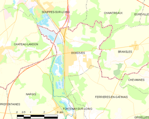
Dordives
- commune in Loiret, France
- Country:
- Postal Code: 45680
- Coordinates: 48° 8' 36" N, 2° 46' 2" E
- GPS tracks (wikiloc): [Link]
- Area: 15.18 sq km
- Population: 3301
- Web site: [Link]

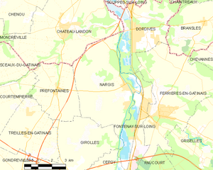
Nargis
- commune in Loiret, France
- Country:
- Postal Code: 45210
- Coordinates: 48° 6' 39" N, 2° 45' 24" E
- GPS tracks (wikiloc): [Link]
- Area: 22.27 sq km
- Population: 1491
- Web site: [Link]

Ferrières-en-Gâtinais
- commune in Loiret, France
- Country:
- Postal Code: 45210
- Coordinates: 48° 5' 25" N, 2° 47' 23" E
- GPS tracks (wikiloc): [Link]
- Area: 27.32 sq km
- Population: 3646
- Web site: [Link]


Girolles
- commune in Loiret, France
- Country:
- Postal Code: 45120
- Coordinates: 48° 3' 42" N, 2° 42' 55" E
- GPS tracks (wikiloc): [Link]
- Area: 13.9 sq km
- Population: 637


Cepoy
- commune in Loiret, France
- Country:
- Postal Code: 45120
- Coordinates: 48° 2' 47" N, 2° 44' 13" E
- GPS tracks (wikiloc): [Link]
- Area: 8.52 sq km
- Population: 2354
- Web site: [Link]

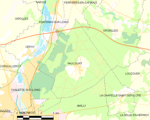
Paucourt
- commune in Loiret, France
- Country:
- Postal Code: 45200
- Coordinates: 48° 2' 9" N, 2° 47' 39" E
- GPS tracks (wikiloc): [Link]
- Area: 20.2 sq km
- Population: 900
- Web site: [Link]