canton of Grostenquin (canton de Grostenquin)
- canton of France (until March 2015)
- Country:

- Capital: Grostenquin
- Coordinates: 48° 59' 32" N, 6° 42' 59" E


- GPS tracks (wikiloc): [Link]
- Wikidata storage: Wikidata: Q1397795
- INSEE canton code: [5714]
Includes regions:

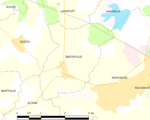
Baronville
- commune in Moselle, France
- Country:
- Postal Code: 57340
- Coordinates: 48° 56' 2" N, 6° 36' 31" E
- GPS tracks (wikiloc): [Link]
- Area: 6.18 sq km
- Population: 372


Biding
- commune in Moselle, France
- Country:
- Postal Code: 57660
- Coordinates: 49° 3' 32" N, 6° 47' 12" E
- GPS tracks (wikiloc): [Link]
- Area: 6.72 sq km
- Population: 328


Bistroff
- commune in Moselle, France
- Country:
- Postal Code: 57660
- Coordinates: 48° 59' 31" N, 6° 42' 51" E
- GPS tracks (wikiloc): [Link]
- Area: 19.28 sq km
- Population: 308


Destry
- commune in Moselle, France
- Country:
- Postal Code: 57340
- Coordinates: 48° 56' 38" N, 6° 35' 6" E
- GPS tracks (wikiloc): [Link]
- Area: 6.93 sq km
- Population: 89
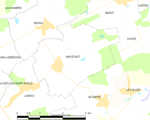
Maxstadt
- commune in Moselle, France
- Country:
- Postal Code: 57660
- Coordinates: 49° 2' 40" N, 6° 47' 37" E
- GPS tracks (wikiloc): [Link]
- Area: 7.91 sq km
- Population: 325
- Web site: [Link]


Vallerange
- commune in Moselle, France
- Country:
- Postal Code: 57340
- Coordinates: 48° 57' 1" N, 6° 41' 8" E
- GPS tracks (wikiloc): [Link]
- Area: 6.64 sq km
- Population: 210


Grostenquin
- commune in Moselle, France
- Country:
- Postal Code: 57660
- Coordinates: 48° 58' 48" N, 6° 44' 20" E
- GPS tracks (wikiloc): [Link]
- Area: 21.77 sq km
- Population: 604


Suisse
- commune in Moselle, France
- Country:
- Postal Code: 57340
- Coordinates: 48° 57' 57" N, 6° 34' 46" E
- GPS tracks (wikiloc): [Link]
- Area: 5.03 sq km
- Population: 104
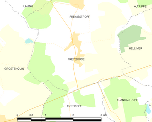
Freybouse
- commune in Moselle, France
- Country:
- Postal Code: 57660
- Coordinates: 49° 0' 17" N, 6° 46' 40" E
- GPS tracks (wikiloc): [Link]
- Area: 5.87 sq km
- Population: 436


Boustroff
- commune in Moselle, France
- Country:
- Postal Code: 57380
- Coordinates: 49° 0' 1" N, 6° 37' 18" E
- GPS tracks (wikiloc): [Link]
- Area: 3.47 sq km
- Population: 150


Harprich
- commune in Moselle, France
- Country:
- Postal Code: 57340
- Coordinates: 48° 57' 42" N, 6° 39' 20" E
- GPS tracks (wikiloc): [Link]
- AboveSeaLevel: 287.5 м m
- Area: 8.78 sq km
- Population: 173

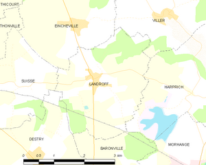
Landroff
- commune in Moselle, France
- Country:
- Postal Code: 57340
- Coordinates: 48° 58' 2" N, 6° 36' 41" E
- GPS tracks (wikiloc): [Link]
- Area: 7.73 sq km
- Population: 272

Lixing-lès-Saint-Avold
- commune in Moselle, France
- Country:
- Postal Code: 57660
- Coordinates: 49° 2' 13" N, 6° 45' 9" E
- GPS tracks (wikiloc): [Link]
- Area: 6.32 sq km
- Population: 700


Viller
- commune in Moselle, France
- Country:
- Postal Code: 57340
- Coordinates: 48° 59' 6" N, 6° 38' 47" E
- GPS tracks (wikiloc): [Link]
- Area: 7.27 sq km
- Population: 205


Leyviller
- commune in Moselle, France
- Country:
- Postal Code: 57660
- Coordinates: 49° 1' 54" N, 6° 50' 7" E
- GPS tracks (wikiloc): [Link]
- Area: 7.25 sq km
- Population: 489


Petit-Tenquin
- commune in Moselle, France
- Country:
- Postal Code: 57660
- Coordinates: 48° 59' 19" N, 6° 51' 41" E
- GPS tracks (wikiloc): [Link]
- Area: 4.88 sq km
- Population: 235

Vahl-Ebersing
- commune in Moselle, France
- Country:
- Postal Code: 57660
- Coordinates: 49° 2' 59" N, 6° 45' 12" E
- GPS tracks (wikiloc): [Link]
- Area: 6.29 sq km
- Population: 517

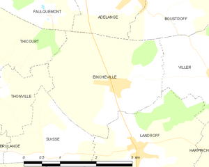
Eincheville
- commune in Moselle, France
- Country:
- Postal Code: 57340
- Coordinates: 48° 58' 58" N, 6° 36' 17" E
- GPS tracks (wikiloc): [Link]
- Area: 6.78 sq km
- Population: 222

Morhange
- commune in Moselle, France
- Country:
- Postal Code: 57340
- Coordinates: 48° 55' 25" N, 6° 38' 9" E
- GPS tracks (wikiloc): [Link]
- Area: 15.38 sq km
- Population: 3484
- Web site: [Link]

Guessling-Hémering
- commune in Moselle, France
- Country:
- Postal Code: 57380
- Coordinates: 49° 1' 31" N, 6° 39' 32" E
- GPS tracks (wikiloc): [Link]
- Area: 10.06 sq km
- Population: 913


Gréning
- commune in Moselle, France
- Country:
- Postal Code: 57660
- Coordinates: 48° 58' 20" N, 6° 50' 37" E
- GPS tracks (wikiloc): [Link]
- Area: 2.78 sq km
- Population: 136


Racrange
- commune in Moselle, France
- Country:
- Postal Code: 57340
- Coordinates: 48° 55' 22" N, 6° 40' 24" E
- GPS tracks (wikiloc): [Link]
- Area: 7.16 sq km
- Population: 606


Lelling
- commune in Moselle, France
- Country:
- Postal Code: 57660
- Coordinates: 49° 2' 27" N, 6° 42' 30" E
- GPS tracks (wikiloc): [Link]
- Area: 4.92 sq km
- Population: 475


Bérig-Vintrange
- commune in Moselle, France
- Country:
- Postal Code: 57660
- Coordinates: 48° 58' 12" N, 6° 41' 54" E
- GPS tracks (wikiloc): [Link]
- Area: 8.52 sq km
- Population: 224


Brulange
- commune in Moselle, France
- Country:
- Postal Code: 57340
- Coordinates: 48° 58' 13" N, 6° 32' 59" E
- GPS tracks (wikiloc): [Link]
- Area: 5.85 sq km
- Population: 104

Altrippe
- commune in Moselle, France
- Country:
- Postal Code: 57660
- Coordinates: 49° 1' 44" N, 6° 49' 11" E
- GPS tracks (wikiloc): [Link]
- Area: 4.88 sq km
- Population: 387

Diffembach-lès-Hellimer
- commune in Moselle, France
- Country:
- Postal Code: 57660
- Coordinates: 49° 0' 10" N, 6° 50' 31" E
- GPS tracks (wikiloc): [Link]
- Area: 5.79 sq km
- Population: 369


Hellimer
- commune in Moselle, France
- Country:
- Postal Code: 57660
- Coordinates: 48° 59' 51" N, 6° 49' 48" E
- GPS tracks (wikiloc): [Link]
- Area: 10.42 sq km
- Population: 573


Erstroff
- commune in Moselle, France
- Country:
- Postal Code: 57660
- Coordinates: 48° 58' 47" N, 6° 46' 33" E
- GPS tracks (wikiloc): [Link]
- Area: 5.05 sq km
- Population: 199

Laning
- commune in Moselle, France
- Country:
- Postal Code: 57660
- Coordinates: 49° 1' 52" N, 6° 45' 49" E
- GPS tracks (wikiloc): [Link]
- Area: 6.71 sq km
- Population: 585


Frémestroff
- commune in Moselle, France
- Country:
- Postal Code: 57660
- Coordinates: 49° 1' 3" N, 6° 46' 50" E
- GPS tracks (wikiloc): [Link]
- Area: 5.51 sq km
- Population: 298