canton of Langon (canton de Langon)
- canton of France
- Country:

- Capital: Langon
- Coordinates: 44° 32' 21" N, 0° 15' 10" E


- GPS tracks (wikiloc): [Link]
- Wikidata storage: Wikidata: Q1725725
- INSEE canton code: [3328]
Includes regions:


Mazères
- commune in Gironde, France
- Country:
- Postal Code: 33210
- Coordinates: 44° 29' 43" N, 0° 15' 31" E
- GPS tracks (wikiloc): [Link]
- Area: 13.14 sq km
- Population: 758
- Web site: [Link]


Léogeats
- commune in Gironde, France
- Country:
- Postal Code: 33210
- Coordinates: 44° 30' 43" N, 0° 22' 0" E
- GPS tracks (wikiloc): [Link]
- Area: 19.61 sq km
- Population: 800
- Web site: [Link]

Castets-en-Dorthe
- former French commune of the department of Gironde, France
- Country:
- Postal Code: 33210
- Coordinates: 44° 33' 42" N, 0° 9' 11" E
- GPS tracks (wikiloc): [Link]
- Area: 8.69 sq km
- Population: 1164
- Web site: [Link]


Saint-Pierre-de-Mons
- commune in Gironde, France
- Country:
- Postal Code: 33210
- Coordinates: 44° 33' 7" N, 0° 13' 14" E
- GPS tracks (wikiloc): [Link]
- Area: 9.27 sq km
- Population: 1179
- Web site: [Link]

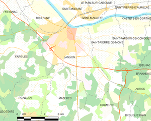
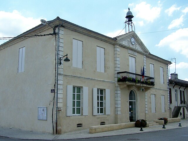
Langon
- commune in Gironde, France
- Country:
- Postal Code: 33210
- Coordinates: 44° 33' 11" N, 0° 14' 58" E
- GPS tracks (wikiloc): [Link]
- AboveSeaLevel: 23 м m
- Area: 13.71 sq km
- Population: 7389
- Web site: [Link]


Fargues
- commune in Gironde, France
- Country:
- Postal Code: 33210
- Coordinates: 44° 32' 9" N, 0° 17' 48" E
- GPS tracks (wikiloc): [Link]
- Area: 15.41 sq km
- Population: 1592
- Web site: [Link]


Bommes
- commune in Gironde, France
- Country:
- Postal Code: 33210
- Coordinates: 44° 32' 47" N, 0° 21' 23" E
- GPS tracks (wikiloc): [Link]
- Area: 5.8 sq km
- Population: 514
- Web site: [Link]

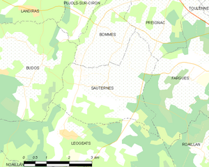
Sauternes
- commune in Gironde, France
- Country:
- Postal Code: 33210
- Coordinates: 44° 31' 54" N, 0° 20' 34" E
- GPS tracks (wikiloc): [Link]
- Area: 11.32 sq km
- Population: 777
- Web site: [Link]


Saint-Pardon-de-Conques
- commune in Gironde, France
- Country:
- Postal Code: 33210
- Coordinates: 44° 33' 15" N, 0° 10' 52" E
- GPS tracks (wikiloc): [Link]
- Area: 6.68 sq km
- Population: 573
- Web site: [Link]

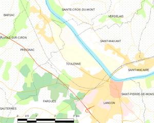
Toulenne
- commune in Gironde, France
- Country:
- Postal Code: 33210
- Coordinates: 44° 33' 29" N, 0° 15' 46" E
- GPS tracks (wikiloc): [Link]
- Area: 6.58 sq km
- Population: 2519
- Web site: [Link]

Bieujac
- commune in Gironde, France
- Country:
- Postal Code: 33210
- Coordinates: 44° 32' 22" N, 0° 9' 18" E
- GPS tracks (wikiloc): [Link]
- Area: 6.97 sq km
- Population: 564
- Web site: [Link]


Roaillan
- commune in Gironde, France
- Country:
- Postal Code: 33210
- Coordinates: 44° 29' 56" N, 0° 16' 55" E
- GPS tracks (wikiloc): [Link]
- Area: 11.48 sq km
- Population: 1633
- Web site: [Link]


Saint-Loubert
- commune in Gironde, France
- Country:
- Postal Code: 33210
- Coordinates: 44° 33' 30" N, 0° 10' 4" E
- GPS tracks (wikiloc): [Link]
- Area: 2.11 sq km
- Population: 229
- Web site: [Link]