canton of Lapoutroie (canton de Lapoutroie)
- canton of France (until March 2015)
- Country:

- Capital: Lapoutroie
- Coordinates: 48° 9' 0" N, 7° 10' 0" E


- GPS tracks (wikiloc): [Link]
- Wikidata storage: Wikidata: Q1398492
- INSEE canton code: [6814]
Includes regions:

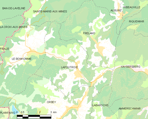
Lapoutroie
- commune in Haut-Rhin, France
- Country:
- Postal Code: 68650
- Coordinates: 48° 9' 9" N, 7° 10' 10" E
- GPS tracks (wikiloc): [Link]
- Area: 21.12 sq km
- Population: 1894
- Web site: [Link]


Labaroche
- commune in Haut-Rhin, France
- Country:
- Postal Code: 68910
- Coordinates: 48° 6' 36" N, 7° 11' 35" E
- GPS tracks (wikiloc): [Link]
- Area: 13.44 sq km
- Population: 2219
- Web site: [Link]


Orbey
- commune in Haut-Rhin, France
- Country:
- Postal Code: 68370
- Coordinates: 48° 7' 35" N, 7° 9' 39" E
- GPS tracks (wikiloc): [Link]
- AboveSeaLevel: 500 м m
- Area: 46.02 sq km
- Population: 3576
- Web site: [Link]

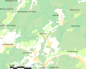
Fréland
- commune in Haut-Rhin, France
- Country:
- Postal Code: 68240
- Coordinates: 48° 10' 16" N, 7° 11' 38" E
- GPS tracks (wikiloc): [Link]
- Area: 19.74 sq km
- Population: 1367


Le Bonhomme
- commune in Haut-Rhin, France
- Country:
- Postal Code: 68650
- Coordinates: 48° 10' 21" N, 7° 6' 48" E
- GPS tracks (wikiloc): [Link]
- Area: 21.98 sq km
- Population: 780