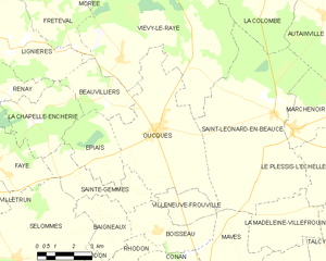
canton of Marchenoir (canton de Marchenoir)
- former canton of France (until March 2015)
- Country:

- Capital: Marchenoir
- Coordinates: 47° 48' 14" N, 1° 24' 14" E


- GPS tracks (wikiloc): [Link]
- Wikidata storage: Wikidata: Q1515884
- INSEE canton code: [4108]
Includes regions:


Conan
- commune in Loir-et-Cher, France
- Country:

- Postal Code: 41290
- Coordinates: 47° 44' 55" N, 1° 17' 11" E


- GPS tracks (wikiloc): [Link]
- Area: 15.3 sq km
- Population: 187

Oucques
- former commune in Loir-et-Cher, France
- Country:

- Postal Code: 41290
- Coordinates: 47° 49' 25" N, 1° 17' 41" E


- GPS tracks (wikiloc): [Link]
- Area: 26.23 sq km
- Population: 1510
Saint-Laurent-des-Bois
- commune in Loir-et-Cher, France
- Country:

- Postal Code: 41240
- Coordinates: 47° 51' 3" N, 1° 26' 52" E


- GPS tracks (wikiloc): [Link]
- Area: 18.32 sq km
- Population: 288


Autainville
- commune in Loir-et-Cher, France
- Country:

- Postal Code: 41240
- Coordinates: 47° 52' 52" N, 1° 24' 56" E


- GPS tracks (wikiloc): [Link]
- Area: 25.01 sq km
- Population: 436
Concriers
- commune in Loir-et-Cher, France
- Country:

- Postal Code: 41370
- Coordinates: 47° 46' 17" N, 1° 28' 28" E


- GPS tracks (wikiloc): [Link]
- Area: 4.84 sq km
- Population: 167


La Madeleine-Villefrouin
- commune in Loir-et-Cher, France
- Country:

- Postal Code: 41370
- Coordinates: 47° 47' 8" N, 1° 24' 48" E


- GPS tracks (wikiloc): [Link]
- AboveSeaLevel: 115 м m
- Area: 9.68 sq km
- Population: 30


Josnes
- commune in Loir-et-Cher, France
- Country:

- Postal Code: 41370
- Coordinates: 47° 47' 47" N, 1° 31' 28" E


- GPS tracks (wikiloc): [Link]
- Area: 20.63 sq km
- Population: 893
Le Plessis-l'Échelle
- commune in Loir-et-Cher, France
- Country:

- Postal Code: 41370
- Coordinates: 47° 48' 50" N, 1° 25' 45" E


- GPS tracks (wikiloc): [Link]
- Area: 11.7 sq km
- Population: 74
Lorges
- commune in Loir-et-Cher, France
- Country:

- Postal Code: 41370
- Coordinates: 47° 49' 25" N, 1° 29' 54" E


- GPS tracks (wikiloc): [Link]
- Area: 13.52 sq km
- Population: 368
- Web site: [Link]
Roches
- commune in Loir-et-Cher, France
- Country:

- Postal Code: 41370
- Coordinates: 47° 47' 44" N, 1° 26' 58" E


- GPS tracks (wikiloc): [Link]
- Area: 8.79 sq km
- Population: 70
Villeneuve-Frouville
- commune in Loir-et-Cher, France
- Country:

- Postal Code: 41290
- Coordinates: 47° 47' 12" N, 1° 18' 32" E


- GPS tracks (wikiloc): [Link]
- Area: 4.36 sq km
- Population: 60
Séris
- commune in Loir-et-Cher, France
- Country:

- Postal Code: 41500
- Coordinates: 47° 45' 25" N, 1° 30' 7" E


- GPS tracks (wikiloc): [Link]
- Area: 17.52 sq km
- Population: 375


Saint-Léonard-en-Beauce
- commune in Loir-et-Cher, France
- Country:

- Postal Code: 41370
- Coordinates: 47° 49' 51" N, 1° 22' 50" E


- GPS tracks (wikiloc): [Link]
- Area: 40.66 sq km
- Population: 643
Boisseau
- commune in Loir-et-Cher, France
- Country:

- Postal Code: 41290
- Coordinates: 47° 46' 20" N, 1° 17' 48" E


- GPS tracks (wikiloc): [Link]
- Area: 8.06 sq km
- Population: 104


Marchenoir
- commune in Loir-et-Cher, France
- Country:

- Postal Code: 41370
- Coordinates: 47° 49' 24" N, 1° 23' 41" E


- GPS tracks (wikiloc): [Link]
- Area: 9.42 sq km
- Population: 639
Briou
- commune in Loir-et-Cher, France
- Country:

- Postal Code: 41370
- Coordinates: 47° 48' 48" N, 1° 28' 41" E


- GPS tracks (wikiloc): [Link]
- Area: 10.17 sq km
- Population: 150
Beauvilliers
- former commune in Loir-et-Cher, France
- Country:

- Postal Code: 41290
- Coordinates: 47° 50' 17" N, 1° 15' 16" E


- GPS tracks (wikiloc): [Link]
- Area: 8 sq km
- Population: 61


Talcy
- commune in Loir-et-Cher, France
- Country:

- Postal Code: 41370
- Coordinates: 47° 46' 8" N, 1° 26' 37" E


- GPS tracks (wikiloc): [Link]
- Area: 15.21 sq km
- Population: 252