canton of Mauvezin (canton de Mauvezin)
- canton of France (until March 2015)
- Country:

- Capital: Mauvezin
- Coordinates: 43° 46' 23" N, 0° 50' 29" E


- GPS tracks (wikiloc): [Link]
- Wikidata storage: Wikidata: Q1264715
- INSEE canton code: [3216]
Includes regions:


Saint-Antonin
- commune in Gers, France
- Country:
- Postal Code: 32120
- Coordinates: 43° 43' 24" N, 0° 48' 53" E
- GPS tracks (wikiloc): [Link]
- Area: 11.19 sq km
- Population: 156


Solomiac
- commune in Gers, France
- Country:
- Postal Code: 32120
- Coordinates: 43° 48' 19" N, 0° 53' 51" E
- GPS tracks (wikiloc): [Link]
- Area: 13.8 sq km
- Population: 491


Mansempuy
- commune in Gers, France
- Country:
- Postal Code: 32120
- Coordinates: 43° 44' 23" N, 0° 48' 44" E
- GPS tracks (wikiloc): [Link]
- Area: 6.33 sq km
- Population: 87
Maravat
- commune in Gers, France
- Country:
- Postal Code: 32120
- Coordinates: 43° 45' 25" N, 0° 45' 10" E
- GPS tracks (wikiloc): [Link]
- Area: 6.46 sq km
- Population: 45

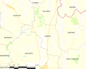
Labrihe
- commune in Gers, France
- Country:
- Postal Code: 32120
- Coordinates: 43° 46' 14" N, 0° 52' 35" E
- GPS tracks (wikiloc): [Link]
- Area: 9.44 sq km
- Population: 208
Homps
- commune in Gers, France
- Country:
- Postal Code: 32120
- Coordinates: 43° 48' 34" N, 0° 51' 2" E
- GPS tracks (wikiloc): [Link]
- Area: 9.24 sq km
- Population: 104
Saint-Brès
- commune in Gers, France
- Country:
- Postal Code: 32120
- Coordinates: 43° 46' 45" N, 0° 46' 11" E
- GPS tracks (wikiloc): [Link]
- Area: 5.89 sq km
- Population: 78

Monfort
- commune in Gers, France
- Country:
- Postal Code: 32120
- Coordinates: 43° 47' 40" N, 0° 49' 26" E
- GPS tracks (wikiloc): [Link]
- Area: 22.49 sq km
- Population: 488
- Web site: [Link]


Mauvezin
- commune in Gers, France
- Country:
- Postal Code: 32120
- Coordinates: 43° 43' 50" N, 0° 52' 41" E
- GPS tracks (wikiloc): [Link]
- AboveSeaLevel: 158 м m
- Area: 32.18 sq km
- Population: 2149
- Web site: [Link]

Sarrant
- commune in Gers, France
- Country:
- Postal Code: 32120
- Coordinates: 43° 46' 28" N, 0° 55' 45" E
- GPS tracks (wikiloc): [Link]
- Area: 19.81 sq km
- Population: 377
- Web site: [Link]

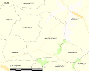
Sainte-Gemme
- commune in Gers, France
- Country:
- Postal Code: 32120
- Coordinates: 43° 46' 53" N, 0° 47' 58" E
- GPS tracks (wikiloc): [Link]
- Area: 10.22 sq km
- Population: 119


Sérempuy
- commune in Gers, France
- Country:
- Postal Code: 32120
- Coordinates: 43° 45' 39" N, 0° 49' 27" E
- GPS tracks (wikiloc): [Link]
- Area: 3.27 sq km
- Population: 34
Saint-Orens
- commune in Gers, France
- Country:
- Postal Code: 32120
- Coordinates: 43° 42' 51" N, 0° 54' 32" E
- GPS tracks (wikiloc): [Link]
- Area: 4.34 sq km
- Population: 80


Bajonnette
- commune in Gers, France
- Country:
- Postal Code: 32120
- Coordinates: 43° 48' 32" N, 0° 46' 9" E
- GPS tracks (wikiloc): [Link]
- Area: 7.48 sq km
- Population: 101


Avensac
- commune in Gers, France
- Country:
- Postal Code: 32120
- Coordinates: 43° 49' 54" N, 0° 54' 8" E
- GPS tracks (wikiloc): [Link]
- Area: 4.8 sq km
- Population: 74