Sérempuy (Sérempuy)

- commune in Gers, France
- Country:

- Postal Code: 32120
- Coordinates: 43° 45' 39" N, 0° 49' 27" E


- GPS tracks (wikiloc): [Link]
- Area: 3.27 sq km
- Population: 34
- Wikipedia en: wiki(en)
- Wikipedia: wiki(fr)
- Wikidata storage: Wikidata: Q765349
- Wikipedia Commons Category: [Link]
- Freebase ID: [/m/03nrv6s]
- GeoNames ID: Alt: [6432138]
- SIREN number: [213204316]
- INSEE municipality code: 32431
Shares border with regions:


Mansempuy
- commune in Gers, France
- Country:
- Postal Code: 32120
- Coordinates: 43° 44' 23" N, 0° 48' 44" E
- GPS tracks (wikiloc): [Link]
- Area: 6.33 sq km
- Population: 87
Maravat
- commune in Gers, France
- Country:
- Postal Code: 32120
- Coordinates: 43° 45' 25" N, 0° 45' 10" E
- GPS tracks (wikiloc): [Link]
- Area: 6.46 sq km
- Population: 45

Monfort
- commune in Gers, France
- Country:
- Postal Code: 32120
- Coordinates: 43° 47' 40" N, 0° 49' 26" E
- GPS tracks (wikiloc): [Link]
- Area: 22.49 sq km
- Population: 488
- Web site: [Link]


Mauvezin
- commune in Gers, France
- Country:
- Postal Code: 32120
- Coordinates: 43° 43' 50" N, 0° 52' 41" E
- GPS tracks (wikiloc): [Link]
- AboveSeaLevel: 158 м m
- Area: 32.18 sq km
- Population: 2149
- Web site: [Link]

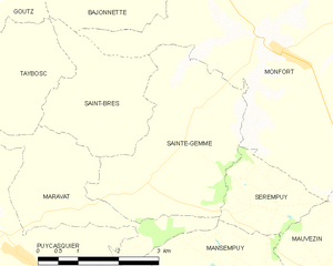
Sainte-Gemme
- commune in Gers, France
- Country:
- Postal Code: 32120
- Coordinates: 43° 46' 53" N, 0° 47' 58" E
- GPS tracks (wikiloc): [Link]
- Area: 10.22 sq km
- Population: 119