canton of Montmirail (canton de Montmirail)
- canton of France
- Country:

- Capital: Montmirail
- Coordinates: 48° 50' 55" N, 3° 36' 29" E


- GPS tracks (wikiloc): [Link]
- Wikidata storage: Wikidata: Q1726348
- INSEE canton code: [5117]
Includes regions:


Vauchamps
- commune in Marne, France
- Country:
- Postal Code: 51210
- Coordinates: 48° 52' 49" N, 3° 36' 57" E
- GPS tracks (wikiloc): [Link]
- Area: 12.88 sq km
- Population: 359


Bergères-sous-Montmirail
- commune in Marne, France
- Country:
- Postal Code: 51210
- Coordinates: 48° 50' 40" N, 3° 35' 28" E
- GPS tracks (wikiloc): [Link]
- Area: 10.52 sq km
- Population: 121


Charleville, Marne
- commune in Marne, France
- Country:
- Postal Code: 51120
- Coordinates: 48° 48' 44" N, 3° 40' 2" E
- GPS tracks (wikiloc): [Link]
- Area: 17.67 sq km
- Population: 249


Boissy-le-Repos
- commune in Marne, France
- Country:
- Postal Code: 51210
- Coordinates: 48° 50' 51" N, 3° 38' 53" E
- GPS tracks (wikiloc): [Link]
- AboveSeaLevel: 160 м m
- Area: 15.3 sq km
- Population: 226


Soizy-aux-Bois
- commune in Marne, France
- Country:
- Postal Code: 51120
- Coordinates: 48° 48' 36" N, 3° 43' 51" E
- GPS tracks (wikiloc): [Link]
- Area: 7.28 sq km
- Population: 179
- Web site: [Link]


La Villeneuve-lès-Charleville
- commune in Marne, France
- Country:
- Postal Code: 51120
- Coordinates: 48° 48' 30" N, 3° 41' 41" E
- GPS tracks (wikiloc): [Link]
- AboveSeaLevel: 216 м m
- Area: 11.17 sq km
- Population: 114
Janvilliers
- commune in Marne, France
- Country:
- Postal Code: 51210
- Coordinates: 48° 53' 39" N, 3° 38' 54" E
- GPS tracks (wikiloc): [Link]
- Area: 8.74 sq km
- Population: 169


Le Vézier
- commune in Marne, France
- Country:
- Postal Code: 51210
- Coordinates: 48° 47' 44" N, 3° 27' 36" E
- GPS tracks (wikiloc): [Link]
- Area: 12.39 sq km
- Population: 195
- Web site: [Link]

Morsains
- commune in Marne, France
- Country:
- Postal Code: 51210
- Coordinates: 48° 47' 50" N, 3° 32' 10" E
- GPS tracks (wikiloc): [Link]
- Area: 14.33 sq km
- Population: 129


Corfélix
- commune in Marne, France
- Country:
- Postal Code: 51210
- Coordinates: 48° 50' 13" N, 3° 41' 55" E
- GPS tracks (wikiloc): [Link]
- Area: 8.27 sq km
- Population: 111


Fromentières
- commune in Marne, France
- Country:
- Postal Code: 51210
- Coordinates: 48° 53' 20" N, 3° 42' 19" E
- GPS tracks (wikiloc): [Link]
- Area: 8.88 sq km
- Population: 380

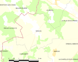
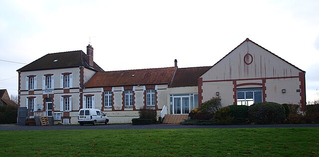
Verdon
- commune in Marne, France
- Country:
- Postal Code: 51210
- Coordinates: 48° 56' 56" N, 3° 37' 17" E
- GPS tracks (wikiloc): [Link]
- Area: 11.39 sq km
- Population: 209


Mécringes
- commune in Marne, France
- Country:
- Postal Code: 51210
- Coordinates: 48° 51' 50" N, 3° 31' 26" E
- GPS tracks (wikiloc): [Link]
- Area: 10.68 sq km
- Population: 193


Le Gault-Soigny
- commune in Marne, France
- Country:
- Postal Code: 51210
- Coordinates: 48° 48' 56" N, 3° 35' 28" E
- GPS tracks (wikiloc): [Link]
- AboveSeaLevel: 194 м m
- Area: 26.09 sq km
- Population: 544


Corrobert
- commune in Marne, France
- Country:
- Postal Code: 51210
- Coordinates: 48° 54' 56" N, 3° 36' 17" E
- GPS tracks (wikiloc): [Link]
- Area: 14.26 sq km
- Population: 201

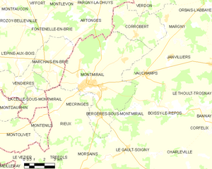
Montmirail
- commune in Marne, France
- Country:
- Postal Code: 51210
- Coordinates: 48° 52' 15" N, 3° 32' 26" E
- GPS tracks (wikiloc): [Link]
- Area: 48.82 sq km
- Population: 3643
- Web site: [Link]


Le Thoult-Trosnay
- commune in Marne, France
- Country:
- Postal Code: 51210
- Coordinates: 48° 51' 3" N, 3° 41' 20" E
- GPS tracks (wikiloc): [Link]
- Area: 14.89 sq km
- Population: 100


Tréfols
- commune in Marne, France
- Country:
- Postal Code: 51210
- Coordinates: 48° 47' 18" N, 3° 29' 55" E
- GPS tracks (wikiloc): [Link]
- Area: 14.39 sq km
- Population: 155


Rieux
- commune in Marne, France
- Country:
- Postal Code: 51210
- Coordinates: 48° 51' 2" N, 3° 30' 1" E
- GPS tracks (wikiloc): [Link]
- Area: 11.56 sq km
- Population: 197
- Web site: [Link]