canton of Montredon-Labessonnié (canton de Montredon-Labessonnié)
- canton of France (until March 2015)
- Country:

- Capital: Montredon-Labessonnié
- Coordinates: 43° 46' 55" N, 2° 22' 9" E


- GPS tracks (wikiloc): [Link]
- Wikidata storage: Wikidata: Q920255
- Library of Congress authority ID: Alt: [n99028478]
- INSEE canton code: [8121]
Includes regions:


Mont-Roc
- commune in Tarn, France
- Country:
- Postal Code: 81120
- Coordinates: 43° 48' 8" N, 2° 22' 9" E
- GPS tracks (wikiloc): [Link]
- Area: 14.18 sq km
- Population: 194


Montredon-Labessonnié
- commune in Tarn, France
- Country:
- Postal Code: 81360
- Coordinates: 43° 43' 13" N, 2° 19' 35" E
- GPS tracks (wikiloc): [Link]
- Area: 110.88 sq km
- Population: 2036
- Web site: [Link]

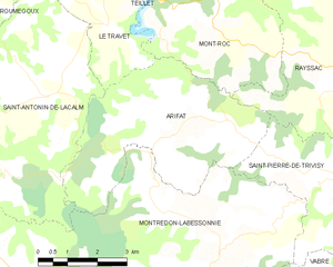
Arifat
- commune in Tarn, France
- Country:
- Postal Code: 81360
- Coordinates: 43° 47' 4" N, 2° 21' 51" E
- GPS tracks (wikiloc): [Link]
- Area: 20.28 sq km
- Population: 159
- Web site: [Link]

Rayssac
- commune in Tarn, France
- Country:
- Postal Code: 81330
- Coordinates: 43° 49' 4" N, 2° 24' 51" E
- GPS tracks (wikiloc): [Link]
- Area: 29.95 sq km
- Population: 253