canton of Nomeny (canton de Nomeny)
- canton of France
- Country:

- Capital: Nomeny
- Coordinates: 48° 51' 5" N, 6° 14' 51" E


- GPS tracks (wikiloc): [Link]
- Wikidata storage: Wikidata: Q1726529
- INSEE canton code: [5423]
Includes regions:


Moivrons
- commune in Meurthe-et-Moselle, France
- Country:
- Postal Code: 54760
- Coordinates: 48° 49' 24" N, 6° 14' 56" E
- GPS tracks (wikiloc): [Link]
- AboveSeaLevel: 278 м m
- Area: 6 sq km
- Population: 481


Mailly-sur-Seille
- commune in Meurthe-et-Moselle, France
- Country:
- Postal Code: 54610
- Coordinates: 48° 54' 38" N, 6° 14' 42" E
- GPS tracks (wikiloc): [Link]
- Area: 6.4 sq km
- Population: 248


Sivry
- commune in Meurthe-et-Moselle, France
- Country:
- Postal Code: 54610
- Coordinates: 48° 49' 52" N, 6° 12' 2" E
- GPS tracks (wikiloc): [Link]
- Area: 5.91 sq km
- Population: 261


Jeandelaincourt
- commune in Meurthe-et-Moselle, France
- Country:
- Postal Code: 54114
- Coordinates: 48° 50' 35" N, 6° 14' 32" E
- GPS tracks (wikiloc): [Link]
- Area: 4.47 sq km
- Population: 801


Malleloy
- commune in Meurthe-et-Moselle, France
- Country:
- Postal Code: 54670
- Coordinates: 48° 47' 41" N, 6° 9' 45" E
- GPS tracks (wikiloc): [Link]
- Area: 4.06 sq km
- Population: 969


Lanfroicourt
- commune in Meurthe-et-Moselle, France
- Country:
- Postal Code: 54760
- Coordinates: 48° 48' 36" N, 6° 19' 50" E
- GPS tracks (wikiloc): [Link]
- Area: 6.19 sq km
- Population: 131


Armaucourt
- commune in Meurthe-et-Moselle, France
- Country:
- Postal Code: 54760
- Coordinates: 48° 48' 59" N, 6° 18' 11" E
- GPS tracks (wikiloc): [Link]
- Area: 3.72 sq km
- Population: 212


Phlin
- commune in Meurthe-et-Moselle, France
- Country:
- Postal Code: 54610
- Coordinates: 48° 54' 43" N, 6° 16' 37" E
- GPS tracks (wikiloc): [Link]
- Area: 3.7 sq km
- Population: 39

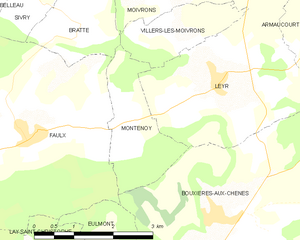
Montenoy
- commune in Meurthe-et-Moselle, France
- Country:
- Postal Code: 54760
- Coordinates: 48° 47' 43" N, 6° 13' 50" E
- GPS tracks (wikiloc): [Link]
- Area: 3.98 sq km
- Population: 417


Thézey-Saint-Martin
- commune in Meurthe-et-Moselle, France
- Country:
- Postal Code: 54610
- Coordinates: 48° 54' 5" N, 6° 17' 46" E
- GPS tracks (wikiloc): [Link]
- Area: 7.95 sq km
- Population: 202


Éply
- commune in Meurthe-et-Moselle, France
- Country:
- Postal Code: 54610
- Coordinates: 48° 55' 11" N, 6° 10' 49" E
- GPS tracks (wikiloc): [Link]
- Area: 11.17 sq km
- Population: 303


Villers-lès-Moivrons
- commune in Meurthe-et-Moselle, France
- Country:
- Postal Code: 54760
- Coordinates: 48° 48' 51" N, 6° 15' 5" E
- GPS tracks (wikiloc): [Link]
- Area: 2.85 sq km
- Population: 149


Rouves
- commune in Meurthe-et-Moselle, France
- Country:
- Postal Code: 54610
- Coordinates: 48° 53' 56" N, 6° 12' 20" E
- GPS tracks (wikiloc): [Link]
- Area: 3.69 sq km
- Population: 106


Létricourt
- commune in Meurthe-et-Moselle, France
- Country:
- Postal Code: 54610
- Coordinates: 48° 52' 32" N, 6° 17' 42" E
- GPS tracks (wikiloc): [Link]
- Area: 7.38 sq km
- Population: 248


Raucourt
- commune in Meurthe-et-Moselle, France
- Country:
- Postal Code: 54610
- Coordinates: 48° 55' 39" N, 6° 13' 5" E
- GPS tracks (wikiloc): [Link]
- Area: 5.06 sq km
- Population: 217

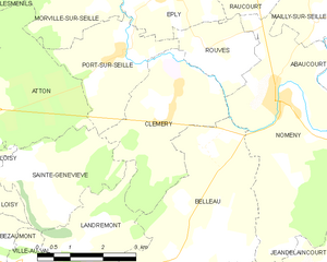
Clémery
- commune in Meurthe-et-Moselle, France
- Country:
- Postal Code: 54610
- Coordinates: 48° 53' 38" N, 6° 11' 9" E
- GPS tracks (wikiloc): [Link]
- Area: 9.45 sq km
- Population: 506


Bey-sur-Seille
- commune in Meurthe-et-Moselle, France
- Country:
- Postal Code: 54760
- Coordinates: 48° 48' 16" N, 6° 20' 32" E
- GPS tracks (wikiloc): [Link]
- Area: 5.53 sq km
- Population: 160

Bratte
- commune in Meurthe-et-Moselle, France
- Country:
- Postal Code: 54610
- Coordinates: 48° 48' 50" N, 6° 12' 56" E
- GPS tracks (wikiloc): [Link]
- Area: 3.28 sq km
- Population: 44


Nomeny
- commune in Meurthe-et-Moselle, France
- Country:
- Postal Code: 54610
- Coordinates: 48° 53' 23" N, 6° 13' 30" E
- GPS tracks (wikiloc): [Link]
- Area: 17.79 sq km
- Population: 1210


Belleau
- commune in Meurthe-et-Moselle, France
- Country:
- Postal Code: 54610
- Coordinates: 48° 49' 48" N, 6° 10' 52" E
- GPS tracks (wikiloc): [Link]
- Area: 20.38 sq km
- Population: 744


Arraye-et-Han
- commune in Meurthe-et-Moselle, France
- Country:
- Postal Code: 54760
- Coordinates: 48° 50' 25" N, 6° 17' 29" E
- GPS tracks (wikiloc): [Link]
- Area: 10.34 sq km
- Population: 350


Faulx
- commune in Meurthe-et-Moselle, France
- Country:
- Postal Code: 54760
- Coordinates: 48° 47' 35" N, 6° 11' 53" E
- GPS tracks (wikiloc): [Link]
- Area: 17.2 sq km
- Population: 1325


Leyr
- commune in Meurthe-et-Moselle, France
- Country:
- Postal Code: 54760
- Coordinates: 48° 48' 12" N, 6° 15' 54" E
- GPS tracks (wikiloc): [Link]
- Area: 10.74 sq km
- Population: 941


Chenicourt
- commune in Meurthe-et-Moselle, France
- Country:
- Postal Code: 54610
- Coordinates: 48° 51' 25" N, 6° 17' 25" E
- GPS tracks (wikiloc): [Link]
- Area: 3.75 sq km
- Population: 229
- Web site: [Link]