Villers-lès-Moivrons (Villers-lès-Moivrons)

- commune in Meurthe-et-Moselle, France
- Country:

- Postal Code: 54760
- Coordinates: 48° 48' 51" N, 6° 15' 5" E


- GPS tracks (wikiloc): [Link]
- Area: 2.85 sq km
- Population: 149
- Wikipedia en: wiki(en)
- Wikipedia: wiki(fr)
- Wikidata storage: Wikidata: Q212857
- Wikipedia Commons Category: [Link]
- Freebase ID: [/m/03qdn_q]
- Freebase ID: [/m/03qdn_q]
- GeoNames ID: Alt: [6436921]
- GeoNames ID: Alt: [6436921]
- SIREN number: [215405770]
- SIREN number: [215405770]
- PACTOLS thesaurus ID: [pcrt7SSDh5ngov]
- PACTOLS thesaurus ID: [pcrt7SSDh5ngov]
- INSEE municipality code: 54577
- INSEE municipality code: 54577
Shares border with regions:


Moivrons
- commune in Meurthe-et-Moselle, France
- Country:
- Postal Code: 54760
- Coordinates: 48° 49' 24" N, 6° 14' 56" E
- GPS tracks (wikiloc): [Link]
- AboveSeaLevel: 278 м m
- Area: 6 sq km
- Population: 481

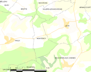
Montenoy
- commune in Meurthe-et-Moselle, France
- Country:
- Postal Code: 54760
- Coordinates: 48° 47' 43" N, 6° 13' 50" E
- GPS tracks (wikiloc): [Link]
- Area: 3.98 sq km
- Population: 417

Bratte
- commune in Meurthe-et-Moselle, France
- Country:
- Postal Code: 54610
- Coordinates: 48° 48' 50" N, 6° 12' 56" E
- GPS tracks (wikiloc): [Link]
- Area: 3.28 sq km
- Population: 44


Leyr
- commune in Meurthe-et-Moselle, France
- Country:
- Postal Code: 54760
- Coordinates: 48° 48' 12" N, 6° 15' 54" E
- GPS tracks (wikiloc): [Link]
- Area: 10.74 sq km
- Population: 941