canton of Ribeauvillé (canton de Ribeauvillé)
- canton of France (until March 2015)
- Country:

- Capital: Ribeauvillé
- Coordinates: 48° 12' 0" N, 7° 19' 0" E


- GPS tracks (wikiloc): [Link]
- Wikidata storage: Wikidata: Q1398605
- Library of Congress authority ID: Alt: [n93052785]
- INSEE canton code: [6820]
Includes regions:


Saint-Hippolyte
- commune in Haut-Rhin, France
- Country:
- Postal Code: 68590
- Coordinates: 48° 13' 55" N, 7° 22' 18" E
- GPS tracks (wikiloc): [Link]
- Area: 17.86 sq km
- Population: 1005
- Web site: [Link]


Rodern
- commune in Haut-Rhin, France
- Country:
- Postal Code: 68590
- Coordinates: 48° 13' 30" N, 7° 21' 13" E
- GPS tracks (wikiloc): [Link]
- AboveSeaLevel: 260 м m
- Area: 7.05 sq km
- Population: 344


Ostheim
- commune in Haut-Rhin, France
- Country:
- Postal Code: 68150
- Coordinates: 48° 9' 36" N, 7° 22' 14" E
- GPS tracks (wikiloc): [Link]
- Area: 8.16 sq km
- Population: 1581
- Web site: [Link]


Bergheim
- commune in Haut-Rhin, France
- Country:
- Postal Code: 68750
- Coordinates: 48° 12' 19" N, 7° 21' 42" E
- GPS tracks (wikiloc): [Link]
- AboveSeaLevel: 211 м m
- Area: 19.16 sq km
- Population: 2111
- Web site: [Link]


Guémar
- commune in Haut-Rhin, France
- Country:
- Postal Code: 68970
- Coordinates: 48° 11' 19" N, 7° 23' 49" E
- GPS tracks (wikiloc): [Link]
- AboveSeaLevel: 193 м m
- Area: 18.22 sq km
- Population: 1330
- Web site: [Link]


Thannenkirch
- commune in Haut-Rhin, France
- Country:
- Postal Code: 68590
- Coordinates: 48° 13' 58" N, 7° 18' 14" E
- GPS tracks (wikiloc): [Link]
- Area: 4.6 sq km
- Population: 438

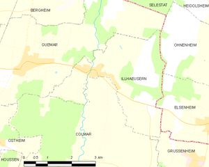
Illhaeusern
- commune in Haut-Rhin, France
- Country:
- Postal Code: 68970
- Coordinates: 48° 11' 4" N, 7° 26' 6" E
- GPS tracks (wikiloc): [Link]
- Area: 10.46 sq km
- Population: 680
- Web site: [Link]

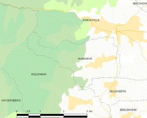
Hunawihr
- commune in Haut-Rhin, France
- Country:
- Postal Code: 68150
- Local Dialing Code: 389
- Coordinates: 48° 10' 49" N, 7° 18' 41" E
- GPS tracks (wikiloc): [Link]
- AboveSeaLevel: 686 м m
- Area: 4.81 sq km
- Population: 598
- Web site: [Link]