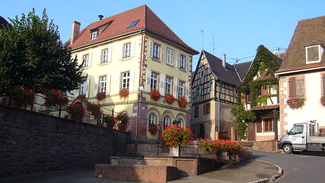
Saint-Hippolyte (Saint-Hippolyte)

- commune in Haut-Rhin, France
- Country:

- Postal Code: 68590
- Coordinates: 48° 13' 55" N, 7° 22' 18" E


- GPS tracks (wikiloc): [Link]
- Area: 17.86 sq km
- Population: 1005
- Web site: http://www.saint-hippolyte-alsace.fr/
- Wikipedia en: wiki(en)
- Wikipedia: wiki(fr)
- Wikidata storage: Wikidata: Q126283
- Wikipedia Commons Category: [Link]
- Freebase ID: [/m/0266gm5]
- Freebase ID: [/m/0266gm5]
- GeoNames ID: Alt: [6441605]
- GeoNames ID: Alt: [6441605]
- SIREN number: [216802967]
- SIREN number: [216802967]
- BnF ID: [15271998x]
- BnF ID: [15271998x]
- INSEE municipality code: 68296
- INSEE municipality code: 68296
Shares border with regions:


Lièpvre
- commune in Haut-Rhin, France
- Country:
- Postal Code: 68660
- Coordinates: 48° 16' 20" N, 7° 16' 57" E
- GPS tracks (wikiloc): [Link]
- Area: 12.55 sq km
- Population: 1751


Rodern
- commune in Haut-Rhin, France
- Country:
- Postal Code: 68590
- Coordinates: 48° 13' 30" N, 7° 21' 13" E
- GPS tracks (wikiloc): [Link]
- AboveSeaLevel: 260 м m
- Area: 7.05 sq km
- Population: 344


Ribeauvillé
- commune in Haut-Rhin, France
- Country:
- Postal Code: 68150
- Coordinates: 48° 11' 43" N, 7° 19' 6" E
- GPS tracks (wikiloc): [Link]
- Area: 32.21 sq km
- Population: 4746
- Web site: [Link]


Rorschwihr
- commune in Haut-Rhin, France
- Country:
- Postal Code: 68590
- Coordinates: 48° 13' 2" N, 7° 21' 46" E
- GPS tracks (wikiloc): [Link]
- AboveSeaLevel: 362 м m
- Area: 2.47 sq km
- Population: 382


Zellenberg
- commune in Haut-Rhin, France
- Country:
- Postal Code: 68340
- Coordinates: 48° 10' 15" N, 7° 19' 11" E
- GPS tracks (wikiloc): [Link]
- AboveSeaLevel: 374 м m
- Area: 4.96 sq km
- Population: 333

Orschwiller
- commune in Bas-Rhin, France
- Country:
- Postal Code: 67600
- Coordinates: 48° 14' 29" N, 7° 22' 57" E
- GPS tracks (wikiloc): [Link]
- Area: 6.32 sq km
- Population: 616
- Web site: [Link]

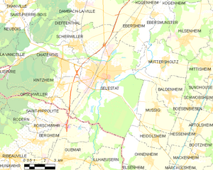
Sélestat
- commune in Bas-Rhin, France
- Country:
- Postal Code: 67600
- Coordinates: 48° 15' 34" N, 7° 27' 15" E
- GPS tracks (wikiloc): [Link]
- AboveSeaLevel: 173 м m
- Area: 44.4 sq km
- Population: 19252
- Web site: [Link]


Bergheim
- commune in Haut-Rhin, France
- Country:
- Postal Code: 68750
- Coordinates: 48° 12' 19" N, 7° 21' 42" E
- GPS tracks (wikiloc): [Link]
- AboveSeaLevel: 211 м m
- Area: 19.16 sq km
- Population: 2111
- Web site: [Link]


Guémar
- commune in Haut-Rhin, France
- Country:
- Postal Code: 68970
- Coordinates: 48° 11' 19" N, 7° 23' 49" E
- GPS tracks (wikiloc): [Link]
- AboveSeaLevel: 193 м m
- Area: 18.22 sq km
- Population: 1330
- Web site: [Link]


Thannenkirch
- commune in Haut-Rhin, France
- Country:
- Postal Code: 68590
- Coordinates: 48° 13' 58" N, 7° 18' 14" E
- GPS tracks (wikiloc): [Link]
- Area: 4.6 sq km
- Population: 438


Sainte-Croix-aux-Mines
- commune in Haut-Rhin, France
- Country:
- Postal Code: 68160
- Coordinates: 48° 15' 44" N, 7° 13' 31" E
- GPS tracks (wikiloc): [Link]
- Area: 27.85 sq km
- Population: 1965
- Web site: [Link]