canton of Romorantin-Lanthenay-Nord (canton de Romorantin-Lanthenay-Nord)
- canton of France
- Country:

- Capital: Romorantin-Lanthenay
- Coordinates: 47° 26' 24" N, 1° 41' 54" E


- GPS tracks (wikiloc): [Link]
- Wikidata storage: Wikidata: Q1726985
- INSEE canton code: [4117]
Includes regions:


Veilleins
- commune in Loir-et-Cher, France
- Country:
- Postal Code: 41230
- Coordinates: 47° 25' 15" N, 1° 40' 13" E
- GPS tracks (wikiloc): [Link]
- Area: 43.26 sq km
- Population: 159

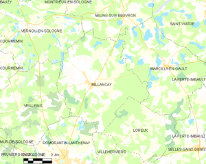
Millançay
- commune in Loir-et-Cher, France
- Country:
- Postal Code: 41200
- Coordinates: 47° 26' 49" N, 1° 46' 22" E
- GPS tracks (wikiloc): [Link]
- Area: 57.94 sq km
- Population: 771


Courmemin
- commune in Loir-et-Cher, France
- Country:
- Postal Code: 41230
- Coordinates: 47° 28' 19" N, 1° 37' 37" E
- GPS tracks (wikiloc): [Link]
- Area: 24.17 sq km
- Population: 526

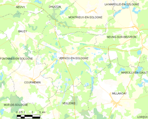
Vernou-en-Sologne
- commune in Loir-et-Cher, France
- Country:
- Postal Code: 41230
- Coordinates: 47° 30' 5" N, 1° 40' 48" E
- GPS tracks (wikiloc): [Link]
- Area: 51.31 sq km
- Population: 618
- Web site: [Link]