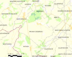
canton of Saint-Amand-Longpré (canton de Saint-Amand-Longpré)
- canton of France (until March 2015)
- Country:

- Capital: Saint-Amand-Longpré
- Coordinates: 47° 41' 14" N, 0° 59' 57" E


- GPS tracks (wikiloc): [Link]
- Wikidata storage: Wikidata: Q1547713
- INSEE canton code: [4119]
Includes regions:
Gombergean
- commune in Loir-et-Cher, France
- Country:

- Postal Code: 41310
- Coordinates: 47° 39' 5" N, 1° 5' 0" E


- GPS tracks (wikiloc): [Link]
- Area: 12.18 sq km
- Population: 196
Crucheray
- commune in Loir-et-Cher, France
- Country:

- Postal Code: 41100
- Coordinates: 47° 43' 41" N, 1° 5' 18" E


- GPS tracks (wikiloc): [Link]
- Area: 25.43 sq km
- Population: 384


Authon
- commune in Loir-et-Cher, France
- Country:

- Postal Code: 41310
- Coordinates: 47° 38' 38" N, 0° 53' 49" E


- GPS tracks (wikiloc): [Link]
- Area: 32.26 sq km
- Population: 710
- Web site: [Link]
Ambloy
- commune in Loir-et-Cher, France
- Country:

- Postal Code: 41310
- Coordinates: 47° 42' 44" N, 0° 58' 4" E


- GPS tracks (wikiloc): [Link]
- Area: 13.16 sq km
- Population: 182


Prunay-Cassereau
- commune in Loir-et-Cher, France
- Country:

- Postal Code: 41310
- Coordinates: 47° 41' 43" N, 0° 55' 16" E


- GPS tracks (wikiloc): [Link]
- Area: 32.85 sq km
- Population: 623
- Web site: [Link]


Huisseau-en-Beauce
- commune in Loir-et-Cher, France
- Country:

- Postal Code: 41310
- Coordinates: 47° 43' 22" N, 1° 0' 36" E


- GPS tracks (wikiloc): [Link]
- Area: 8.98 sq km
- Population: 419
Saint-Gourgon
- commune in Loir-et-Cher, France
- Country:

- Postal Code: 41310
- Coordinates: 47° 39' 39" N, 1° 1' 2" E


- GPS tracks (wikiloc): [Link]
- Area: 10.15 sq km
- Population: 115
Villechauve
- commune in Loir-et-Cher, France
- Country:

- Postal Code: 41310
- Coordinates: 47° 38' 59" N, 0° 56' 30" E


- GPS tracks (wikiloc): [Link]
- Area: 11.02 sq km
- Population: 289
Sasnières
- commune in Loir-et-Cher, France
- Country:

- Postal Code: 41310
- Coordinates: 47° 43' 6" N, 0° 56' 8" E


- GPS tracks (wikiloc): [Link]
- Area: 7.83 sq km
- Population: 107


Lancé
- commune in Loir-et-Cher, France
- Country:

- Postal Code: 41310
- Coordinates: 47° 41' 38" N, 1° 4' 3" E


- GPS tracks (wikiloc): [Link]
- Area: 18.01 sq km
- Population: 469

Nourray
- commune in Loir-et-Cher, France
- Country:

- Postal Code: 41310
- Coordinates: 47° 43' 3" N, 1° 3' 31" E


- GPS tracks (wikiloc): [Link]
- Area: 12.17 sq km
- Population: 115


Saint-Amand-Longpré
- commune in Loir-et-Cher, France
- Country:

- Postal Code: 41310
- Coordinates: 47° 41' 24" N, 1° 0' 59" E


- GPS tracks (wikiloc): [Link]
- AboveSeaLevel: 124 м m
- Area: 21.37 sq km
- Population: 1232
- Web site: [Link]
Villeporcher
- commune in Loir-et-Cher, France
- Country:

- Postal Code: 41310
- Coordinates: 47° 38' 25" N, 0° 59' 37" E


- GPS tracks (wikiloc): [Link]
- Area: 12.1 sq km
- Population: 154