canton of Sarre-Union (canton de Sarre-Union)
- canton of France (until March 2015)
- Country:

- Capital: Sarre-Union
- Coordinates: 48° 57' 16" N, 7° 6' 2" E


- GPS tracks (wikiloc): [Link]
- Area: 223.21 sq km
- Population: 14378
- Wikidata storage: Wikidata: Q1398501
- INSEE canton code: [6720]
Includes regions:

Bissert
- commune in Bas-Rhin, France
- Country:
- Postal Code: 67260
- Coordinates: 48° 56' 31" N, 7° 1' 25" E
- GPS tracks (wikiloc): [Link]
- Area: 3.37 sq km
- Population: 156
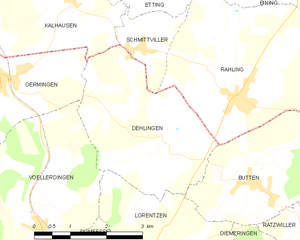
Dehlingen
- commune in Bas-Rhin, France
- Country:
- Postal Code: 67430
- Coordinates: 48° 58' 52" N, 7° 11' 30" E
- GPS tracks (wikiloc): [Link]
- Area: 10.02 sq km
- Population: 362

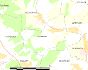
Domfessel
- commune in Bas-Rhin, France
- Country:
- Postal Code: 67430
- Coordinates: 48° 57' 4" N, 7° 9' 13" E
- GPS tracks (wikiloc): [Link]
- Area: 6.23 sq km
- Population: 299
Diedendorf
- commune in Bas-Rhin, France
- Country:
- Postal Code: 67260
- Coordinates: 48° 52' 46" N, 7° 2' 42" E
- GPS tracks (wikiloc): [Link]
- Area: 10.11 sq km
- Population: 315


Keskastel
- commune in Bas-Rhin, France
- Country:
- Postal Code: 67260
- Coordinates: 48° 58' 17" N, 7° 2' 38" E
- GPS tracks (wikiloc): [Link]
- AboveSeaLevel: 215 м m
- Area: 18.87 sq km
- Population: 1529
- Web site: [Link]
Hinsingen
- commune in Bas-Rhin, France
- Country:
- Postal Code: 67260
- Coordinates: 48° 57' 10" N, 6° 59' 30" E
- GPS tracks (wikiloc): [Link]
- Area: 2.98 sq km
- Population: 89

Herbitzheim
- commune in Bas-Rhin, France
- Country:
- Postal Code: 67260
- Coordinates: 49° 0' 53" N, 7° 5' 3" E
- GPS tracks (wikiloc): [Link]
- Area: 21.73 sq km
- Population: 1849


Sarrewerden
- commune in Bas-Rhin, France
- Country:
- Postal Code: 67260
- Coordinates: 48° 55' 22" N, 7° 5' 1" E
- GPS tracks (wikiloc): [Link]
- Area: 16.73 sq km
- Population: 860
- Web site: [Link]


Oermingen
- commune in Bas-Rhin, France
- Country:
- Postal Code: 67970
- Coordinates: 48° 59' 57" N, 7° 7' 43" E
- GPS tracks (wikiloc): [Link]
- Area: 14.63 sq km
- Population: 1252
- Web site: [Link]
Siltzheim
- commune in Bas-Rhin, France
- Country:
- Postal Code: 67260
- Coordinates: 49° 3' 44" N, 7° 5' 37" E
- GPS tracks (wikiloc): [Link]
- Area: 6.96 sq km
- Population: 654
- Web site: [Link]
Rimsdorf
- commune in Bas-Rhin, France
- Country:
- Postal Code: 67260
- Coordinates: 48° 55' 46" N, 7° 7' 34" E
- GPS tracks (wikiloc): [Link]
- Area: 6.07 sq km
- Population: 313

Schopperten
- commune in Bas-Rhin, France
- Country:
- Postal Code: 67260
- Coordinates: 48° 56' 49" N, 7° 3' 3" E
- GPS tracks (wikiloc): [Link]
- Area: 4.19 sq km
- Population: 433
- Web site: [Link]


Wolfskirchen
- commune in Bas-Rhin, France
- Country:
- Postal Code: 67260
- Coordinates: 48° 52' 48" N, 7° 4' 28" E
- GPS tracks (wikiloc): [Link]
- Area: 10.48 sq km
- Population: 354
Ratzwiller
- commune in Bas-Rhin, France
- Country:
- Postal Code: 67430
- Coordinates: 48° 57' 20" N, 7° 14' 23" E
- GPS tracks (wikiloc): [Link]
- Area: 8.72 sq km
- Population: 254


Harskirchen
- commune in Bas-Rhin, France
- Country:
- Postal Code: 67260
- Coordinates: 48° 55' 55" N, 7° 2' 21" E
- GPS tracks (wikiloc): [Link]
- Area: 14.42 sq km
- Population: 852
- Web site: [Link]

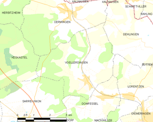
Vœllerdingen
- commune in Bas-Rhin, France
- Country:
- Postal Code: 67430
- Coordinates: 48° 57' 42" N, 7° 8' 27" E
- GPS tracks (wikiloc): [Link]
- Area: 13.05 sq km
- Population: 394


Sarre-Union
- commune in Bas-Rhin, France
- Country:
- Postal Code: 67260
- Coordinates: 48° 56' 27" N, 7° 5' 19" E
- GPS tracks (wikiloc): [Link]
- Area: 15.39 sq km
- Population: 2906
- Web site: [Link]


Lorentzen
- commune in Bas-Rhin, France
- Country:
- Postal Code: 67430
- Coordinates: 48° 57' 9" N, 7° 10' 29" E
- GPS tracks (wikiloc): [Link]
- Area: 7.85 sq km
- Population: 229

Butten
- commune in Bas-Rhin, France
- Country:
- Postal Code: 67430
- Coordinates: 48° 58' 15" N, 7° 13' 16" E
- GPS tracks (wikiloc): [Link]
- Area: 15.19 sq km
- Population: 680
- Web site: [Link]


Altwiller
- commune in Bas-Rhin, France
- Country:
- Postal Code: 67260
- Coordinates: 48° 55' 49" N, 6° 58' 49" E
- GPS tracks (wikiloc): [Link]
- Area: 16.22 sq km
- Population: 417