
Sarre-Union (Sarre-Union)

- commune in Bas-Rhin, France
- Country:

- Postal Code: 67260
- Coordinates: 48° 56' 27" N, 7° 5' 19" E


- GPS tracks (wikiloc): [Link]
- Area: 15.39 sq km
- Population: 2906
- Web site: http://www.sarre-union.fr
- Wikipedia en: wiki(en)
- Wikipedia: wiki(fr)
- Wikidata storage: Wikidata: Q21569
- Wikipedia Commons Category: [Link]
- Freebase ID: [/m/0dt0j0]
- Freebase ID: [/m/0dt0j0]
- GeoNames ID: Alt: [2975957]
- GeoNames ID: Alt: [2975957]
- SIREN number: [216704346]
- SIREN number: [216704346]
- BnF ID: [15271576h]
- BnF ID: [15271576h]
- VIAF ID: Alt: [150542345]
- VIAF ID: Alt: [150542345]
- Library of Congress authority ID: Alt: [nr94026026]
- Library of Congress authority ID: Alt: [nr94026026]
- PACTOLS thesaurus ID: [pcrtg3rSFdf3L9]
- PACTOLS thesaurus ID: [pcrtg3rSFdf3L9]
- MusicBrainz area ID: [9650f2a4-daeb-4051-9ce1-f0a8b15b7829]
- MusicBrainz area ID: [9650f2a4-daeb-4051-9ce1-f0a8b15b7829]
- INSEE municipality code: 67434
- INSEE municipality code: 67434
Shares border with regions:

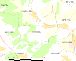
Domfessel
- commune in Bas-Rhin, France
- Country:
- Postal Code: 67430
- Coordinates: 48° 57' 4" N, 7° 9' 13" E
- GPS tracks (wikiloc): [Link]
- Area: 6.23 sq km
- Population: 299


Keskastel
- commune in Bas-Rhin, France
- Country:
- Postal Code: 67260
- Coordinates: 48° 58' 17" N, 7° 2' 38" E
- GPS tracks (wikiloc): [Link]
- AboveSeaLevel: 215 м m
- Area: 18.87 sq km
- Population: 1529
- Web site: [Link]


Sarrewerden
- commune in Bas-Rhin, France
- Country:
- Postal Code: 67260
- Coordinates: 48° 55' 22" N, 7° 5' 1" E
- GPS tracks (wikiloc): [Link]
- Area: 16.73 sq km
- Population: 860
- Web site: [Link]
Rimsdorf
- commune in Bas-Rhin, France
- Country:
- Postal Code: 67260
- Coordinates: 48° 55' 46" N, 7° 7' 34" E
- GPS tracks (wikiloc): [Link]
- Area: 6.07 sq km
- Population: 313

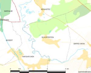
Schopperten
- commune in Bas-Rhin, France
- Country:
- Postal Code: 67260
- Coordinates: 48° 56' 49" N, 7° 3' 3" E
- GPS tracks (wikiloc): [Link]
- Area: 4.19 sq km
- Population: 433
- Web site: [Link]


Harskirchen
- commune in Bas-Rhin, France
- Country:
- Postal Code: 67260
- Coordinates: 48° 55' 55" N, 7° 2' 21" E
- GPS tracks (wikiloc): [Link]
- Area: 14.42 sq km
- Population: 852
- Web site: [Link]

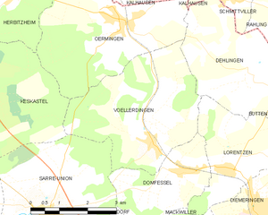
Vœllerdingen
- commune in Bas-Rhin, France
- Country:
- Postal Code: 67430
- Coordinates: 48° 57' 42" N, 7° 8' 27" E
- GPS tracks (wikiloc): [Link]
- Area: 13.05 sq km
- Population: 394