Vœllerdingen (Vœllerdingen)

- commune in Bas-Rhin, France
- Country:

- Postal Code: 67430
- Coordinates: 48° 57' 42" N, 7° 8' 27" E


- GPS tracks (wikiloc): [Link]
- Area: 13.05 sq km
- Population: 394
- Wikipedia en: wiki(en)
- Wikipedia: wiki(fr)
- Wikidata storage: Wikidata: Q21567
- Wikipedia Commons Category: [Link]
- Freebase ID: [/m/03m9cmk]
- Freebase ID: [/m/03m9cmk]
- GeoNames ID: Alt: [6614998]
- GeoNames ID: Alt: [6614998]
- SIREN number: [216705087]
- SIREN number: [216705087]
- VIAF ID: Alt: [126728660]
- VIAF ID: Alt: [126728660]
- INSEE municipality code: 67508
- INSEE municipality code: 67508
Shares border with regions:
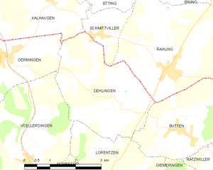
Dehlingen
- commune in Bas-Rhin, France
- Country:
- Postal Code: 67430
- Coordinates: 48° 58' 52" N, 7° 11' 30" E
- GPS tracks (wikiloc): [Link]
- Area: 10.02 sq km
- Population: 362

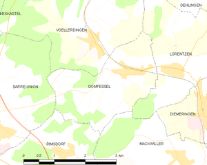
Domfessel
- commune in Bas-Rhin, France
- Country:
- Postal Code: 67430
- Coordinates: 48° 57' 4" N, 7° 9' 13" E
- GPS tracks (wikiloc): [Link]
- Area: 6.23 sq km
- Population: 299


Keskastel
- commune in Bas-Rhin, France
- Country:
- Postal Code: 67260
- Coordinates: 48° 58' 17" N, 7° 2' 38" E
- GPS tracks (wikiloc): [Link]
- AboveSeaLevel: 215 м m
- Area: 18.87 sq km
- Population: 1529
- Web site: [Link]


Oermingen
- commune in Bas-Rhin, France
- Country:
- Postal Code: 67970
- Coordinates: 48° 59' 57" N, 7° 7' 43" E
- GPS tracks (wikiloc): [Link]
- Area: 14.63 sq km
- Population: 1252
- Web site: [Link]


Sarre-Union
- commune in Bas-Rhin, France
- Country:
- Postal Code: 67260
- Coordinates: 48° 56' 27" N, 7° 5' 19" E
- GPS tracks (wikiloc): [Link]
- Area: 15.39 sq km
- Population: 2906
- Web site: [Link]


Lorentzen
- commune in Bas-Rhin, France
- Country:
- Postal Code: 67430
- Coordinates: 48° 57' 9" N, 7° 10' 29" E
- GPS tracks (wikiloc): [Link]
- Area: 7.85 sq km
- Population: 229