canton of Soulaines-Dhuys (canton de Soulaines-Dhuys)
- canton of France
- Country:

- Capital: Soulaines-Dhuys
- Coordinates: 48° 22' 36" N, 4° 44' 4" E


- GPS tracks (wikiloc): [Link]
- Wikidata storage: Wikidata: Q1727525
- INSEE canton code: [1021]
Includes regions:


Chaumesnil
- commune in Aube, France
- Country:
- Postal Code: 10500
- Coordinates: 48° 21' 37" N, 4° 35' 43" E
- GPS tracks (wikiloc): [Link]
- AboveSeaLevel: 139 м m
- Area: 11.07 sq km
- Population: 98


Lévigny
- commune in Aube, France
- Country:
- Postal Code: 10200
- Coordinates: 48° 18' 6" N, 4° 42' 27" E
- GPS tracks (wikiloc): [Link]
- Area: 13.75 sq km
- Population: 98
Fresnay
- commune in Aube, France
- Country:
- Postal Code: 10200
- Coordinates: 48° 18' 52" N, 4° 45' 4" E
- GPS tracks (wikiloc): [Link]
- AboveSeaLevel: 130 м m
- Area: 7.54 sq km
- Population: 46
Thil
- commune in Aube, France
- Country:
- Postal Code: 10200
- Coordinates: 48° 20' 51" N, 4° 47' 9" E
- GPS tracks (wikiloc): [Link]
- AboveSeaLevel: 185 м m
- Area: 19.42 sq km
- Population: 133

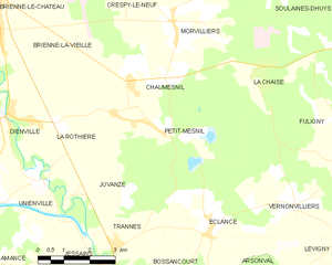
Petit-Mesnil
- commune in Aube, France
- Country:
- Postal Code: 10500
- Coordinates: 48° 20' 43" N, 4° 35' 48" E
- GPS tracks (wikiloc): [Link]
- Area: 14.83 sq km
- Population: 227


Vernonvilliers
- commune in Aube, France
- Country:
- Postal Code: 10200
- Coordinates: 48° 18' 54" N, 4° 40' 48" E
- GPS tracks (wikiloc): [Link]
- Area: 7.66 sq km
- Population: 66
Thors
- commune in Aube, France
- Country:
- Postal Code: 10200
- Coordinates: 48° 18' 15" N, 4° 48' 41" E
- GPS tracks (wikiloc): [Link]
- Area: 8.33 sq km
- Population: 72


Juzanvigny
- commune in Aube, France
- Country:
- Postal Code: 10500
- Coordinates: 48° 24' 53" N, 4° 35' 20" E
- GPS tracks (wikiloc): [Link]
- Area: 7.64 sq km
- Population: 127

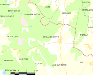
Soulaines-Dhuys
- commune in Aube, France
- Country:
- Postal Code: 10200
- Coordinates: 48° 22' 27" N, 4° 44' 0" E
- GPS tracks (wikiloc): [Link]
- Area: 20.06 sq km
- Population: 417


Épothémont
- commune in Aube, France
- Country:
- Postal Code: 10500
- Coordinates: 48° 25' 4" N, 4° 39' 27" E
- GPS tracks (wikiloc): [Link]
- Area: 10.43 sq km
- Population: 183


La Rothière
- commune in Aube, France
- Country:
- Postal Code: 10500
- Coordinates: 48° 20' 42" N, 4° 33' 28" E
- GPS tracks (wikiloc): [Link]
- Area: 7.13 sq km
- Population: 113


Ville-sur-Terre
- commune in Aube, France
- Country:
- Postal Code: 10200
- Coordinates: 48° 19' 55" N, 4° 44' 52" E
- GPS tracks (wikiloc): [Link]
- Area: 16.1 sq km
- Population: 108
Maisons-lès-Soulaines
- commune in Aube, France
- Country:
- Postal Code: 10200
- Coordinates: 48° 17' 21" N, 4° 47' 16" E
- GPS tracks (wikiloc): [Link]
- Area: 6.16 sq km
- Population: 57


Saulcy
- commune in Aube, France
- Country:
- Postal Code: 10200
- Coordinates: 48° 16' 41" N, 4° 50' 1" E
- GPS tracks (wikiloc): [Link]
- Area: 11.39 sq km
- Population: 74


La Ville-aux-Bois
- commune in Aube, France
- Country:
- Postal Code: 10500
- Coordinates: 48° 24' 25" N, 4° 41' 25" E
- GPS tracks (wikiloc): [Link]
- Area: 5.56 sq km
- Population: 23


La Chaise
- commune in Aube, France
- Country:
- Postal Code: 10500
- Coordinates: 48° 21' 45" N, 4° 39' 35" E
- GPS tracks (wikiloc): [Link]
- Area: 8.81 sq km
- Population: 39


Crespy-le-Neuf
- commune in Aube, France
- Country:
- Postal Code: 10500
- Coordinates: 48° 23' 47" N, 4° 35' 40" E
- GPS tracks (wikiloc): [Link]
- Area: 10.19 sq km
- Population: 150

Éclance
- commune in Aube, France
- Country:
- Postal Code: 10200
- Coordinates: 48° 18' 22" N, 4° 38' 4" E
- GPS tracks (wikiloc): [Link]
- Area: 11.48 sq km
- Population: 101

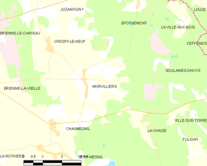
Morvilliers
- commune in Aube, France
- Country:
- Postal Code: 10500
- Coordinates: 48° 22' 50" N, 4° 37' 9" E
- GPS tracks (wikiloc): [Link]
- Area: 15.64 sq km
- Population: 309


Fuligny
- commune in Aube, France
- Country:
- Postal Code: 10200
- Coordinates: 48° 19' 55" N, 4° 42' 24" E
- GPS tracks (wikiloc): [Link]
- Area: 10.34 sq km
- Population: 52
Colombé-la-Fosse
- commune in Aube, France
- Country:
- Postal Code: 10200
- Coordinates: 48° 15' 50" N, 4° 47' 15" E
- GPS tracks (wikiloc): [Link]
- Area: 9.31 sq km
- Population: 196