canton of Brumath (canton de Brumath)

- canton of France
- Country:

- Capital: Brumath
- Coordinates: 48° 44' 0" N, 7° 43' 0" E


- GPS tracks (wikiloc): [Link]
- Population: 52244
- Wikipedia en: wiki(en)
- Wikipedia: wiki(fr)
- Wikidata storage: Wikidata: Q1398567
- INSEE canton code: [6703]
Includes regions:


Bernolsheim
- commune in Bas-Rhin, France
- Country:
- Postal Code: 67170
- Coordinates: 48° 45' 22" N, 7° 41' 23" E
- GPS tracks (wikiloc): [Link]
- Area: 3.39 sq km
- Population: 609


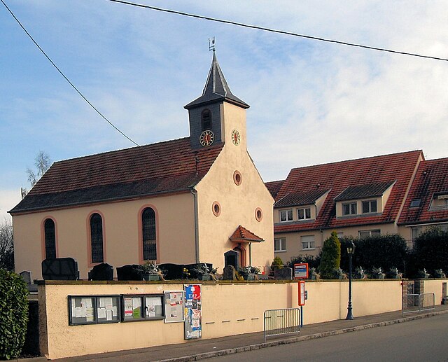
Donnenheim
- commune in Bas-Rhin, France
- Country:
- Postal Code: 67170
- Coordinates: 48° 43' 4" N, 7° 39' 6" E
- GPS tracks (wikiloc): [Link]
- Area: 3.76 sq km
- Population: 309

Bietlenheim
- commune in Bas-Rhin, France
- Country:
- Postal Code: 67720
- Coordinates: 48° 43' 10" N, 7° 46' 53" E
- GPS tracks (wikiloc): [Link]
- Area: 2.13 sq km
- Population: 271
- Web site: [Link]


Geudertheim
- commune in Bas-Rhin, France
- Country:
- Postal Code: 67170
- Coordinates: 48° 43' 25" N, 7° 45' 16" E
- GPS tracks (wikiloc): [Link]
- Area: 11.27 sq km
- Population: 2439
- Web site: [Link]


Kriegsheim
- commune in Bas-Rhin, France
- Country:
- Postal Code: 67170
- Coordinates: 48° 45' 30" N, 7° 43' 46" E
- GPS tracks (wikiloc): [Link]
- Area: 3.93 sq km
- Population: 757
- Web site: [Link]


Mittelschaeffolsheim
- commune in Bas-Rhin, France
- Country:
- Postal Code: 67170
- Coordinates: 48° 42' 2" N, 7° 39' 7" E
- GPS tracks (wikiloc): [Link]
- Area: 2.64 sq km
- Population: 550
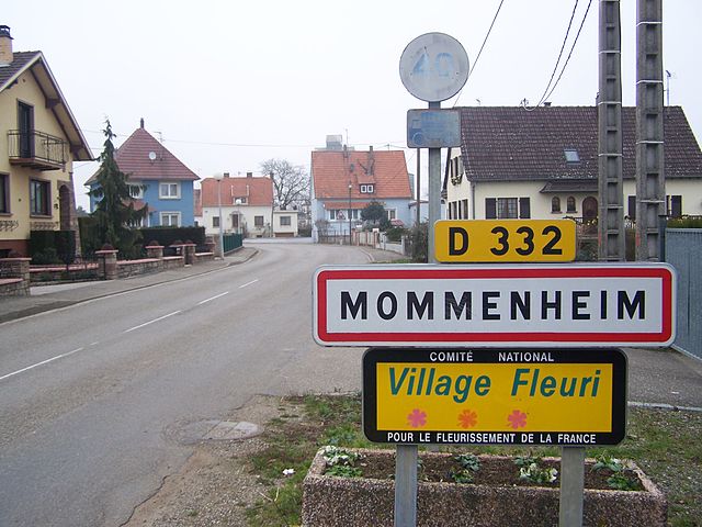

Mommenheim
- commune in Bas-Rhin, France
- Country:
- Postal Code: 67670
- Coordinates: 48° 45' 27" N, 7° 38' 39" E
- GPS tracks (wikiloc): [Link]
- Area: 8.16 sq km
- Population: 1793


Olwisheim
- commune in Bas-Rhin, France
- Country:
- Postal Code: 67170
- Coordinates: 48° 41' 49" N, 7° 40' 33" E
- GPS tracks (wikiloc): [Link]
- Area: 2.96 sq km
- Population: 489

Gambsheim
- commune in Bas-Rhin, France
- Country:
- Postal Code: 67760
- Coordinates: 48° 41' 32" N, 7° 53' 0" E
- GPS tracks (wikiloc): [Link]
- Area: 17.38 sq km
- Population: 4726


Rottelsheim
- commune in Bas-Rhin, France
- Country:
- Postal Code: 67170
- Coordinates: 48° 45' 24" N, 7° 42' 52" E
- GPS tracks (wikiloc): [Link]
- Area: 2.39 sq km
- Population: 318
- Web site: [Link]


Krautwiller
- commune in Bas-Rhin, France
- Country:
- Postal Code: 67170
- Coordinates: 48° 44' 17" N, 7° 41' 8" E
- GPS tracks (wikiloc): [Link]
- Area: 1.48 sq km
- Population: 217


Kurtzenhouse
- commune in Bas-Rhin, France
- Country:
- Postal Code: 67240
- Coordinates: 48° 44' 24" N, 7° 48' 25" E
- GPS tracks (wikiloc): [Link]
- Area: 3.58 sq km
- Population: 1046


Kilstett
- commune in Bas-Rhin, France
- Country:
- Postal Code: 67840
- Coordinates: 48° 40' 32" N, 7° 51' 22" E
- GPS tracks (wikiloc): [Link]
- Area: 6.9 sq km
- Population: 2566


Vendenheim
- commune in Bas-Rhin, France
- Country:
- Postal Code: 67550
- Coordinates: 48° 40' 3" N, 7° 42' 47" E
- GPS tracks (wikiloc): [Link]
- Area: 15.89 sq km
- Population: 5512
- Web site: [Link]


Weyersheim
- commune in Bas-Rhin, France
- Country:
- Postal Code: 67720
- Coordinates: 48° 42' 59" N, 7° 48' 14" E
- GPS tracks (wikiloc): [Link]
- Area: 18.89 sq km
- Population: 3329


La Wantzenau
- commune in Bas-Rhin, France
- Country:
- Postal Code: 67610
- Coordinates: 48° 39' 29" N, 7° 49' 42" E
- GPS tracks (wikiloc): [Link]
- Area: 25.39 sq km
- Population: 5768
- Web site: [Link]


Gries
- commune in Bas-Rhin, France
- Country:
- Postal Code: 67240
- Coordinates: 48° 45' 17" N, 7° 48' 59" E
- GPS tracks (wikiloc): [Link]
- Area: 12.23 sq km
- Population: 2747


Brumath
- commune in Bas-Rhin, France
- Country:
- Postal Code: 67170
- Coordinates: 48° 43' 55" N, 7° 42' 30" E
- GPS tracks (wikiloc): [Link]
- AboveSeaLevel: 150 м m
- Area: 29.54 sq km
- Population: 9840
- Web site: [Link]

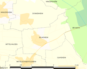
Bilwisheim
- commune in Bas-Rhin, France
- Country:
- Postal Code: 67170
- Coordinates: 48° 42' 35" N, 7° 39' 31" E
- GPS tracks (wikiloc): [Link]
- Area: 2.56 sq km
- Population: 444


Hœrdt
- commune in Bas-Rhin, France
- Country:
- Postal Code: 67720
- Coordinates: 48° 41' 47" N, 7° 47' 2" E
- GPS tracks (wikiloc): [Link]
- Area: 16.56 sq km
- Population: 4337
- Web site: [Link]