canton of Châteaumeillant (canton de Châteaumeillant)

- canton of France
- Country:

- Capital: Châteaumeillant
- Coordinates: 46° 33' 46" N, 2° 12' 5" E


- GPS tracks (wikiloc): [Link]
- Population: 15119
- Wikipedia en: wiki(en)
- Wikipedia: wiki(fr)
- Wikidata storage: Wikidata: Q1724933
- Freebase ID: [/m/05sy1rj]
- INSEE canton code: [1808]
Includes regions:

Beddes
- commune in Cher, France
- Country:
- Postal Code: 18370
- Coordinates: 46° 36' 21" N, 2° 12' 47" E
- GPS tracks (wikiloc): [Link]
- Area: 12.92 sq km
- Population: 87


Châteaumeillant
- commune in Cher, France
- Country:
- Postal Code: 18370
- Coordinates: 46° 33' 43" N, 2° 12' 2" E
- GPS tracks (wikiloc): [Link]
- Area: 42.48 sq km
- Population: 1933
- Web site: [Link]


Saint-Priest-la-Marche
- commune in Cher, France
- Country:
- Postal Code: 18370
- Coordinates: 46° 26' 56" N, 2° 10' 35" E
- GPS tracks (wikiloc): [Link]
- Area: 20.33 sq km
- Population: 227

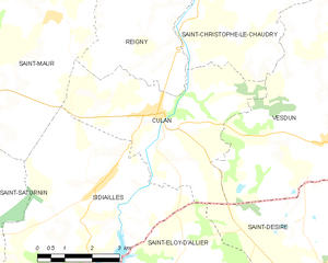
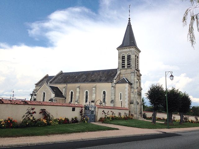
Culan
- commune in Cher, France
- Country:
- Postal Code: 18270
- Coordinates: 46° 32' 51" N, 2° 20' 57" E
- GPS tracks (wikiloc): [Link]
- AboveSeaLevel: 270 м m
- Area: 20.23 sq km
- Population: 728


Reigny
- commune in Cher, France
- Country:
- Postal Code: 18270
- Coordinates: 46° 34' 35" N, 2° 21' 9" E
- GPS tracks (wikiloc): [Link]
- AboveSeaLevel: 405 м m
- Area: 24.61 sq km
- Population: 262


Saint-Saturnin
- commune in Cher, France
- Country:
- Postal Code: 18370
- Coordinates: 46° 30' 27" N, 2° 14' 16" E
- GPS tracks (wikiloc): [Link]
- Area: 39.04 sq km
- Population: 418


Préveranges
- commune in Cher, France
- Country:
- Postal Code: 18370
- Coordinates: 46° 25' 57" N, 2° 15' 17" E
- GPS tracks (wikiloc): [Link]
- Area: 38.16 sq km
- Population: 544
- Web site: [Link]


Saint-Maur
- commune in Cher, France
- Country:
- Postal Code: 18270
- Coordinates: 46° 34' 48" N, 2° 17' 55" E
- GPS tracks (wikiloc): [Link]
- AboveSeaLevel: 273 м m
- Area: 25.62 sq km
- Population: 284

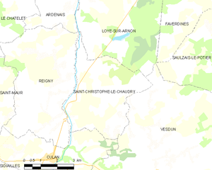
Saint-Christophe-le-Chaudry
- commune in Cher, France
- Country:
- Postal Code: 18270
- Coordinates: 46° 34' 54" N, 2° 22' 8" E
- GPS tracks (wikiloc): [Link]
- Area: 17.52 sq km
- Population: 105


Saint-Jeanvrin
- commune in Cher, France
- Country:
- Postal Code: 18370
- Coordinates: 46° 35' 44" N, 2° 14' 2" E
- GPS tracks (wikiloc): [Link]
- Area: 17.53 sq km
- Population: 161

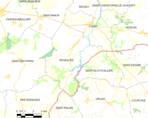
Sidiailles
- commune in Cher, France
- Country:
- Postal Code: 18270
- Coordinates: 46° 30' 26" N, 2° 19' 8" E
- GPS tracks (wikiloc): [Link]
- Area: 31.96 sq km
- Population: 305