canton of Clamecy (canton de Clamecy)

- canton of France
- Country:

- Capital: Clamecy
- Coordinates: 47° 27' 4" N, 3° 30' 37" E


- GPS tracks (wikiloc): [Link]
- Area: 665.05 sq km
- Population: 14369
- Wikipedia en: wiki(en)
- Wikipedia: wiki(fr)
- Wikidata storage: Wikidata: Q658007
- INSEE canton code: [5803]
Includes regions:


Dornecy
- commune in Nièvre, France
- Country:
- Postal Code: 58530
- Coordinates: 47° 26' 10" N, 3° 35' 4" E
- GPS tracks (wikiloc): [Link]
- Area: 17.35 sq km
- Population: 491


Clamecy
- commune in Nièvre, France
- Country:
- Postal Code: 58500
- Coordinates: 47° 27' 36" N, 3° 31' 10" E
- GPS tracks (wikiloc): [Link]
- Area: 30.26 sq km
- Population: 3867
- Web site: [Link]


Trucy-l'Orgueilleux
- commune in Nièvre, France
- Country:
- Postal Code: 58460
- Coordinates: 47° 26' 47" N, 3° 24' 45" E
- GPS tracks (wikiloc): [Link]
- Area: 13.54 sq km
- Population: 221
- Web site: [Link]


Villiers-sur-Yonne
- commune in Nièvre, France
- Country:
- Postal Code: 58500
- Coordinates: 47° 24' 39" N, 3° 34' 32" E
- GPS tracks (wikiloc): [Link]
- Area: 15.86 sq km
- Population: 279


Surgy
- commune in Nièvre, France
- Country:
- Postal Code: 58500
- Coordinates: 47° 30' 33" N, 3° 30' 54" E
- GPS tracks (wikiloc): [Link]
- Area: 16.03 sq km
- Population: 345

Pousseaux
- commune in Nièvre, France
- Country:
- Postal Code: 58500
- Coordinates: 47° 30' 50" N, 3° 31' 38" E
- GPS tracks (wikiloc): [Link]
- Area: 11.11 sq km
- Population: 201
Rix
- commune in Nièvre, France
- Country:
- Postal Code: 58500
- Coordinates: 47° 25' 51" N, 3° 29' 52" E
- GPS tracks (wikiloc): [Link]
- Area: 3.92 sq km
- Population: 155

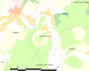
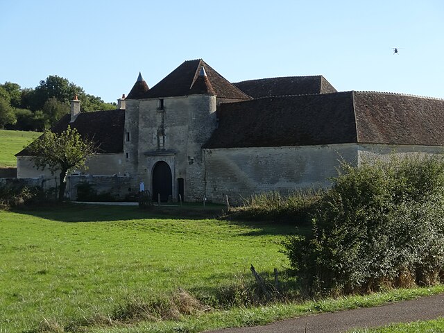
Chevroches
- commune in Nièvre, France
- Country:
- Postal Code: 58500
- Coordinates: 47° 26' 59" N, 3° 32' 44" E
- GPS tracks (wikiloc): [Link]
- Area: 3.21 sq km
- Population: 126

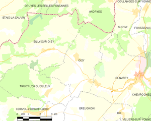
Oisy
- commune in Nièvre, France
- Country:
- Postal Code: 58500
- Coordinates: 47° 28' 8" N, 3° 26' 44" E
- GPS tracks (wikiloc): [Link]
- Area: 17.5 sq km
- Population: 311


Ouagne
- commune in Nièvre, France
- Country:
- Postal Code: 58500
- Coordinates: 47° 23' 50" N, 3° 29' 42" E
- GPS tracks (wikiloc): [Link]
- Area: 11.72 sq km
- Population: 157

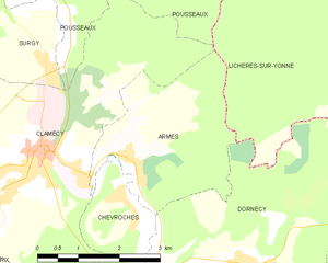
Armes
- commune in Nièvre, France
- Country:
- Postal Code: 58500
- Coordinates: 47° 27' 31" N, 3° 32' 52" E
- GPS tracks (wikiloc): [Link]
- Area: 8.49 sq km
- Population: 298
Breugnon
- commune in Nièvre, France
- Country:
- Postal Code: 58460
- Coordinates: 47° 25' 42" N, 3° 27' 8" E
- GPS tracks (wikiloc): [Link]
- Area: 13.35 sq km
- Population: 178


Billy-sur-Oisy
- commune in Nièvre, France
- Country:
- Postal Code: 58500
- Coordinates: 47° 28' 47" N, 3° 24' 46" E
- GPS tracks (wikiloc): [Link]
- Area: 26.65 sq km
- Population: 379


Brèves
- commune in Nièvre, France
- Country:
- Postal Code: 58530
- Coordinates: 47° 25' 5" N, 3° 36' 21" E
- GPS tracks (wikiloc): [Link]
- Area: 16.64 sq km
- Population: 266
Shares border with regions:

canton of Varzy
- canton of France (until March 2015)
- Country:
- Capital: Varzy
- Coordinates: 47° 22' 47" N, 3° 23' 1" E
- GPS tracks (wikiloc): [Link]
- Area: 261.6 sq km


canton of Coulanges-sur-Yonne
- former canton of France
- Country:
- Capital: Coulanges-sur-Yonne
- Coordinates: 47° 33' 33" N, 3° 33' 35" E
- GPS tracks (wikiloc): [Link]

canton of Courson-les-Carrières
- canton of France (until March 2015)
- Country:
- Capital: Courson-les-Carrières
- Coordinates: 47° 37' 29" N, 3° 27' 0" E
- GPS tracks (wikiloc): [Link]