canton of Crépy-en-Valois (canton de Crépy-en-Valois)

- canton of France
- Country:

- Capital: Crépy-en-Valois
- Coordinates: 49° 15' 45" N, 2° 53' 7" E


- GPS tracks (wikiloc): [Link]
- Population: 34981
- Wikipedia en: wiki(en)
- Wikipedia: wiki(fr)
- Wikidata storage: Wikidata: Q620927
- VIAF ID: Alt: [146737448]
- INSEE canton code: [6009]
Includes regions:

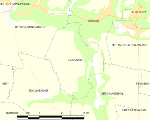
Glaignes
- commune in Oise, France
- Country:
- Postal Code: 60129
- Coordinates: 49° 16' 20" N, 2° 51' 7" E
- GPS tracks (wikiloc): [Link]
- Area: 5.42 sq km
- Population: 358


Gilocourt
- commune in Oise, France
- Country:
- Postal Code: 60129
- Coordinates: 49° 17' 32" N, 2° 52' 46" E
- GPS tracks (wikiloc): [Link]
- Area: 6.93 sq km
- Population: 643


Béthisy-Saint-Martin
- commune in Oise, France
- Country:
- Postal Code: 60320
- Coordinates: 49° 17' 41" N, 2° 48' 55" E
- GPS tracks (wikiloc): [Link]
- Area: 9.82 sq km
- Population: 1141


Béthancourt-en-Valois
- commune in Oise, France
- Country:
- Postal Code: 60129
- Coordinates: 49° 17' 5" N, 2° 52' 38" E
- GPS tracks (wikiloc): [Link]
- Area: 4.12 sq km
- Population: 237
- Web site: [Link]


Saintines
- commune in Oise, France
- Country:
- Postal Code: 60410
- Coordinates: 49° 18' 23" N, 2° 46' 10" E
- GPS tracks (wikiloc): [Link]
- Area: 2.87 sq km
- Population: 1034


Rouville
- commune in Oise, France
- Country:
- Postal Code: 60800
- Coordinates: 49° 12' 28" N, 2° 52' 21" E
- GPS tracks (wikiloc): [Link]
- Area: 7 sq km
- Population: 263
- Web site: [Link]


Rocquemont
- commune in Oise, France
- Country:
- Postal Code: 60800
- Coordinates: 49° 15' 32" N, 2° 49' 6" E
- GPS tracks (wikiloc): [Link]
- Area: 6.26 sq km
- Population: 115


Vaumoise
- commune in Oise, France
- Country:
- Postal Code: 60117
- Coordinates: 49° 14' 12" N, 2° 58' 47" E
- GPS tracks (wikiloc): [Link]
- Area: 3.13 sq km
- Population: 973
- Web site: [Link]


Néry
- commune in Oise, France
- Country:
- Postal Code: 60320
- Coordinates: 49° 16' 53" N, 2° 46' 42" E
- GPS tracks (wikiloc): [Link]
- Area: 16.34 sq km
- Population: 668


Orrouy
- commune in Oise, France
- Country:
- Postal Code: 60129
- Coordinates: 49° 17' 36" N, 2° 51' 37" E
- GPS tracks (wikiloc): [Link]
- Area: 16.14 sq km
- Population: 582


Feigneux
- commune in Oise, France
- Country:
- Postal Code: 60800
- Coordinates: 49° 15' 33" N, 2° 55' 51" E
- GPS tracks (wikiloc): [Link]
- Area: 11.41 sq km
- Population: 447


Duvy
- commune in Oise, France
- Country:
- Postal Code: 60800
- Coordinates: 49° 14' 10" N, 2° 51' 18" E
- GPS tracks (wikiloc): [Link]
- Area: 8.51 sq km
- Population: 459

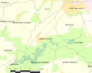
Ormoy-Villers
- commune in Oise, France
- Country:
- Postal Code: 60800
- Coordinates: 49° 11' 47" N, 2° 50' 25" E
- GPS tracks (wikiloc): [Link]
- Area: 10.37 sq km
- Population: 633

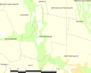
Séry-Magneval
- commune in Oise, France
- Country:
- Postal Code: 60800
- Coordinates: 49° 15' 28" N, 2° 51' 18" E
- GPS tracks (wikiloc): [Link]
- Area: 6.02 sq km
- Population: 286


Vauciennes
- commune in Oise, France
- Country:
- Postal Code: 60117
- Coordinates: 49° 14' 11" N, 3° 1' 49" E
- GPS tracks (wikiloc): [Link]
- Area: 6.36 sq km
- Population: 683

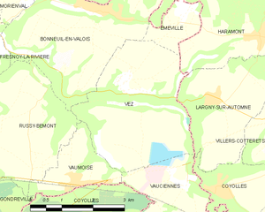
Vez
- commune in Oise, France
- Country:
- Postal Code: 60117
- Coordinates: 49° 15' 50" N, 3° 0' 9" E
- GPS tracks (wikiloc): [Link]
- Area: 10.88 sq km
- Population: 301
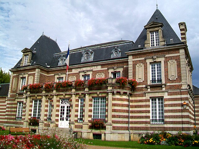
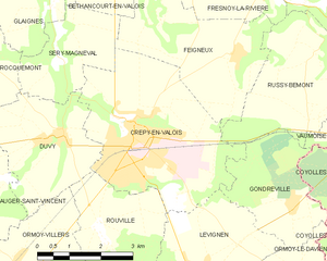
Crépy-en-Valois
- commune in Oise, France
- Country:
- Postal Code: 60800
- Coordinates: 49° 14' 4" N, 2° 53' 15" E
- GPS tracks (wikiloc): [Link]
- AboveSeaLevel: 93 м m
- Area: 16.28 sq km
- Population: 15049
- Web site: [Link]


Trumilly
- commune in Oise, France
- Country:
- Postal Code: 60800
- Coordinates: 49° 14' 34" N, 2° 48' 8" E
- GPS tracks (wikiloc): [Link]
- Area: 12.94 sq km
- Population: 513


Bonneuil-en-Valois
- commune in Oise, France
- Country:
- Postal Code: 60123
- Coordinates: 49° 17' 5" N, 2° 59' 37" E
- GPS tracks (wikiloc): [Link]
- Area: 12.81 sq km
- Population: 1037
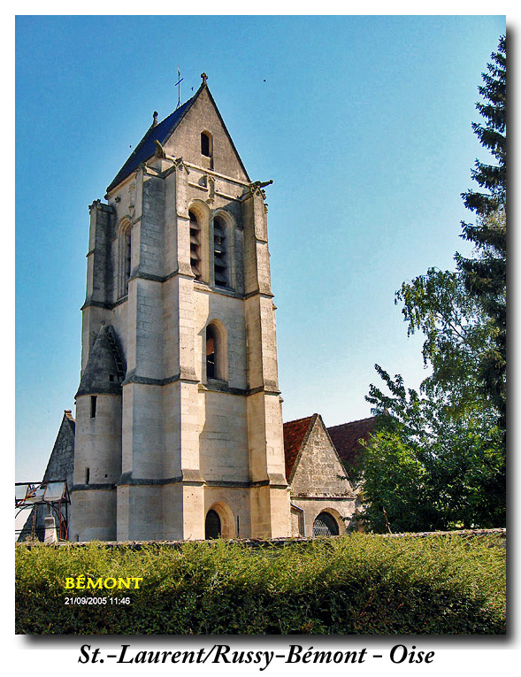

Russy-Bémont
- commune in Oise, France
- Country:
- Postal Code: 60117
- Coordinates: 49° 14' 36" N, 2° 57' 54" E
- GPS tracks (wikiloc): [Link]
- Area: 9.75 sq km
- Population: 207

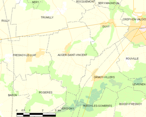
Auger-Saint-Vincent
- commune in Oise, France
- Country:
- Postal Code: 60800
- Coordinates: 49° 13' 7" N, 2° 48' 29" E
- GPS tracks (wikiloc): [Link]
- Area: 13.97 sq km
- Population: 496


Fresnoy-la-Rivière
- commune in Oise, France
- Country:
- Postal Code: 60127
- Coordinates: 49° 17' 4" N, 2° 54' 58" E
- GPS tracks (wikiloc): [Link]
- Area: 6.81 sq km
- Population: 641


Béthisy-Saint-Pierre
- commune in Oise, France
- Country:
- Postal Code: 60320
- Coordinates: 49° 18' 4" N, 2° 48' 11" E
- GPS tracks (wikiloc): [Link]
- Area: 6.53 sq km
- Population: 3120

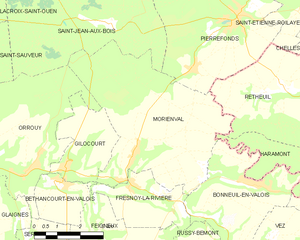
Morienval
- commune in Oise, France
- Country:
- Postal Code: 60127
- Coordinates: 49° 17' 53" N, 2° 55' 12" E
- GPS tracks (wikiloc): [Link]
- Area: 25.74 sq km
- Population: 1063
- Web site: [Link]

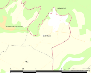
Éméville
- commune in Oise, France
- Country:
- Postal Code: 60123
- Coordinates: 49° 17' 3" N, 3° 1' 40" E
- GPS tracks (wikiloc): [Link]
- Area: 1.84 sq km
- Population: 291