Rouville (Rouville)

- commune in Oise, France
- Country:

- Postal Code: 60800
- Coordinates: 49° 12' 28" N, 2° 52' 21" E


- GPS tracks (wikiloc): [Link]
- Area: 7 sq km
- Population: 263
- Web site: http://www.rouville60.fr/
- Wikipedia en: wiki(en)
- Wikipedia: wiki(fr)
- Wikidata storage: Wikidata: Q1166693
- Wikipedia Commons Category: [Link]
- Freebase ID: [/m/03qh46x]
- GeoNames ID: Alt: [6438932]
- SIREN number: [216005462]
- BnF ID: [15267787z]
- INSEE municipality code: 60552
Shares border with regions:


Duvy
- commune in Oise, France
- Country:
- Postal Code: 60800
- Coordinates: 49° 14' 10" N, 2° 51' 18" E
- GPS tracks (wikiloc): [Link]
- Area: 8.51 sq km
- Population: 459


Lévignen
- commune in Oise, France
- Country:
- Postal Code: 60800
- Coordinates: 49° 11' 49" N, 2° 54' 52" E
- GPS tracks (wikiloc): [Link]
- Area: 13.9 sq km
- Population: 915

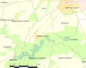
Ormoy-Villers
- commune in Oise, France
- Country:
- Postal Code: 60800
- Coordinates: 49° 11' 47" N, 2° 50' 25" E
- GPS tracks (wikiloc): [Link]
- Area: 10.37 sq km
- Population: 633
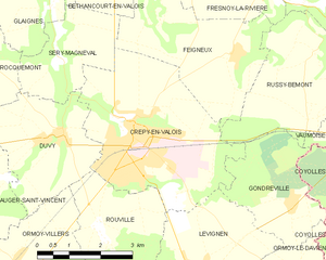
Crépy-en-Valois
- commune in Oise, France
- Country:
- Postal Code: 60800
- Coordinates: 49° 14' 4" N, 2° 53' 15" E
- GPS tracks (wikiloc): [Link]
- AboveSeaLevel: 93 м m
- Area: 16.28 sq km
- Population: 15049
- Web site: [Link]