canton of Gamaches (canton de Gamaches)

- canton of France
- Country:

- Capital: Gamaches
- Coordinates: 49° 59' 15" N, 1° 33' 29" E


- GPS tracks (wikiloc): [Link]
- Population: 23906
- Wikipedia en: wiki(en)
- Wikipedia: wiki(fr)
- Wikidata storage: Wikidata: Q739348
- Freebase ID: [/m/03y6dg3]
- INSEE canton code: [8017]
Includes regions:


Cerisy-Buleux
- commune in Somme, France
- Country:
- Postal Code: 80140
- Coordinates: 49° 58' 34" N, 1° 44' 20" E
- GPS tracks (wikiloc): [Link]
- Area: 5.6 sq km
- Population: 265


Buigny-lès-Gamaches
- commune in Somme, France
- Country:
- Postal Code: 80220
- Coordinates: 50° 1' 28" N, 1° 33' 59" E
- GPS tracks (wikiloc): [Link]
- Area: 4.77 sq km
- Population: 413


Bouvaincourt-sur-Bresle
- commune in Somme, France
- Country:
- Postal Code: 80220
- Coordinates: 50° 1' 51" N, 1° 29' 22" E
- GPS tracks (wikiloc): [Link]
- Area: 6.82 sq km
- Population: 836


Beauchamps
- commune in Somme, France
- Country:
- Postal Code: 80770
- Coordinates: 50° 1' 4" N, 1° 30' 31" E
- GPS tracks (wikiloc): [Link]
- Area: 7.22 sq km
- Population: 1006
- Web site: [Link]


Biencourt
- commune in Somme, France
- Country:
- Postal Code: 80140
- Coordinates: 49° 58' 32" N, 1° 41' 33" E
- GPS tracks (wikiloc): [Link]
- Area: 2.22 sq km
- Population: 129

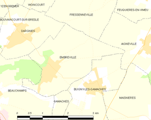
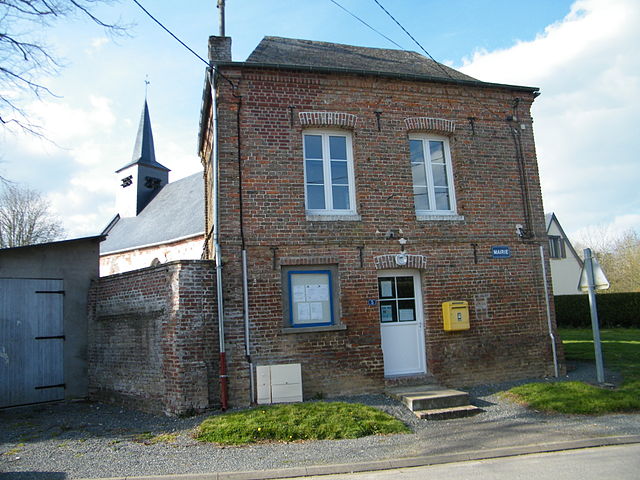
Embreville
- commune in Somme, France
- Country:
- Postal Code: 80570
- Coordinates: 50° 1' 49" N, 1° 32' 35" E
- GPS tracks (wikiloc): [Link]
- Area: 5.33 sq km
- Population: 566
- Web site: [Link]

Framicourt
- commune in Somme, France
- Country:
- Postal Code: 80140
- Coordinates: 49° 57' 25" N, 1° 40' 24" E
- GPS tracks (wikiloc): [Link]
- Area: 5.02 sq km
- Population: 190


Frettemeule
- commune in Somme, France
- Country:
- Postal Code: 80220
- Coordinates: 50° 0' 0" N, 1° 38' 38" E
- GPS tracks (wikiloc): [Link]
- AboveSeaLevel: 90 м m
- Area: 7.45 sq km
- Population: 316


Gamaches
- commune in Somme, France
- Country:
- Postal Code: 80220
- Coordinates: 49° 59' 12" N, 1° 33' 26" E
- GPS tracks (wikiloc): [Link]
- Area: 9.92 sq km
- Population: 2643
- Web site: [Link]


Aigneville
- commune in Somme, France
- Country:
- Postal Code: 80210
- Coordinates: 50° 2' 7" N, 1° 36' 59" E
- GPS tracks (wikiloc): [Link]
- Area: 10.76 sq km
- Population: 878
- Web site: [Link]


Maisnières
- commune in Somme, France
- Country:
- Postal Code: 80220
- Coordinates: 50° 0' 55" N, 1° 36' 59" E
- GPS tracks (wikiloc): [Link]
- Area: 12.73 sq km
- Population: 517


Martainneville
- commune in Somme, France
- Country:
- Postal Code: 80140
- Coordinates: 50° 0' 0" N, 1° 42' 24" E
- GPS tracks (wikiloc): [Link]
- Area: 7.58 sq km
- Population: 434


Bouillancourt-en-Séry
- commune in Somme, France
- Country:
- Postal Code: 80220
- Coordinates: 49° 57' 44" N, 1° 37' 41" E
- GPS tracks (wikiloc): [Link]
- Area: 16.11 sq km
- Population: 563


Bouttencourt
- commune in Somme, France
- Country:
- Postal Code: 80220
- Coordinates: 49° 56' 8" N, 1° 37' 50" E
- GPS tracks (wikiloc): [Link]
- Area: 7.73 sq km
- Population: 950

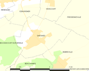
Dargnies
- commune in Somme, France
- Country:
- Postal Code: 80570
- Coordinates: 50° 2' 30" N, 1° 31' 32" E
- GPS tracks (wikiloc): [Link]
- Area: 3.67 sq km
- Population: 1281
- Web site: [Link]

Rambures
- commune in Somme, France
- Country:
- Postal Code: 80140
- Coordinates: 49° 56' 33" N, 1° 42' 12" E
- GPS tracks (wikiloc): [Link]
- Area: 9.9 sq km
- Population: 355


Tilloy-Floriville
- commune in Somme, France
- Country:
- Postal Code: 80220
- Coordinates: 49° 59' 16" N, 1° 36' 37" E
- GPS tracks (wikiloc): [Link]
- Area: 8.09 sq km
- Population: 394

Le Translay
- commune in Somme, France
- Country:
- Postal Code: 80140
- Coordinates: 49° 58' 10" N, 1° 40' 32" E
- GPS tracks (wikiloc): [Link]
- Area: 5.61 sq km
- Population: 237

Vismes
- commune in Somme, France
- Country:
- Postal Code: 80140
- Coordinates: 50° 0' 44" N, 1° 40' 20" E
- GPS tracks (wikiloc): [Link]
- Area: 13.26 sq km
- Population: 476