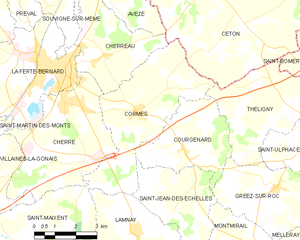
canton of La Ferté-Bernard (canton de La Ferté-Bernard)
- canton of France (until March 2015)
- Country:

- Capital: La Ferté-Bernard
- Coordinates: 48° 11' 24" N, 0° 38' 42" E


- GPS tracks (wikiloc): [Link]
- Area: 315.61 sq km
- Population: 24885
- Wikipedia en: wiki(en)
- Wikipedia: wiki(fr)
- Wikidata storage: Wikidata: Q653341
- VIAF ID: Alt: [243876219]
- INSEE canton code: [7205]
Includes regions:

Avezé
- commune in Sarthe, France
- Country:
- Postal Code: 72400
- Coordinates: 48° 13' 38" N, 0° 40' 38" E
- GPS tracks (wikiloc): [Link]
- Area: 20.81 sq km
- Population: 744
Souvigné-sur-Même
- commune in Sarthe, France
- Country:
- Postal Code: 72400
- Coordinates: 48° 13' 11" N, 0° 38' 12" E
- GPS tracks (wikiloc): [Link]
- Area: 6.28 sq km
- Population: 179

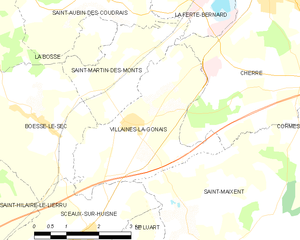
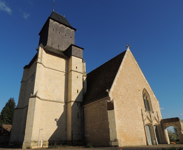
Villaines-la-Gonais
- commune in Sarthe, France
- Country:
- Postal Code: 72400
- Coordinates: 48° 8' 10" N, 0° 36' 6" E
- GPS tracks (wikiloc): [Link]
- Area: 10.34 sq km
- Population: 556
- Web site: [Link]
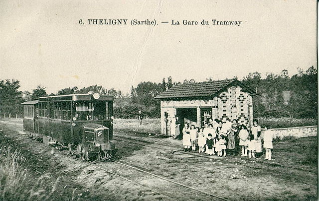

Théligny
- commune in Sarthe, France
- Country:
- Postal Code: 72320
- Coordinates: 48° 10' 31" N, 0° 47' 59" E
- GPS tracks (wikiloc): [Link]
- Area: 14.31 sq km
- Population: 219


Saint-Aubin-des-Coudrais
- commune in Sarthe, France
- Country:
- Postal Code: 72400
- Coordinates: 48° 10' 21" N, 0° 35' 5" E
- GPS tracks (wikiloc): [Link]
- Area: 17.42 sq km
- Population: 918

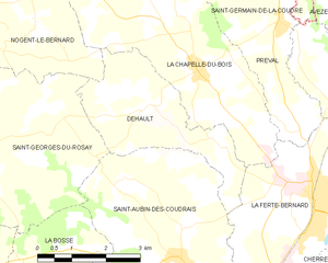
Dehault
- commune in Sarthe, France
- Country:
- Postal Code: 72400
- Coordinates: 48° 12' 37" N, 0° 34' 12" E
- GPS tracks (wikiloc): [Link]
- Area: 8.94 sq km
- Population: 272


Cherreau
- commune in Sarthe, France
- Country:
- Postal Code: 72400
- Coordinates: 48° 11' 34" N, 0° 40' 58" E
- GPS tracks (wikiloc): [Link]
- Area: 11.64 sq km
- Population: 938

Cormes
- commune in Sarthe, France
- Country:
- Postal Code: 72400
- Coordinates: 48° 10' 12" N, 0° 42' 17" E
- GPS tracks (wikiloc): [Link]
- Area: 19 sq km
- Population: 906
- Web site: [Link]


Saint-Martin-des-Monts
- commune in Sarthe, France
- Country:
- Postal Code: 72400
- Coordinates: 48° 8' 57" N, 0° 35' 46" E
- GPS tracks (wikiloc): [Link]
- Area: 5.72 sq km
- Population: 186
- Web site: [Link]


Cherré, Sarthe
- commune in Sarthe, France
- Country:
- Postal Code: 72400
- Coordinates: 48° 10' 21" N, 0° 39' 30" E
- GPS tracks (wikiloc): [Link]
- Area: 18.73 sq km
- Population: 1731
- Web site: [Link]


Préval
- commune in Sarthe, France
- Country:
- Postal Code: 72400
- Coordinates: 48° 14' 5" N, 0° 37' 26" E
- GPS tracks (wikiloc): [Link]
- Area: 7.62 sq km
- Population: 685


La Chapelle-du-Bois
- commune in Sarthe, France
- Country:
- Postal Code: 72400
- Coordinates: 48° 13' 15" N, 0° 35' 33" E
- GPS tracks (wikiloc): [Link]
- Area: 16.53 sq km
- Population: 883

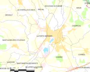
La Ferté-Bernard
- commune in Sarthe, France
- Country:
- Postal Code: 72400
- Coordinates: 48° 11' 12" N, 0° 39' 16" E
- GPS tracks (wikiloc): [Link]
- Area: 14.96 sq km
- Population: 8875
- Web site: [Link]