canton of La Ravoire (canton de La Ravoire)

- canton of France
 Hiking in canton of La Ravoire
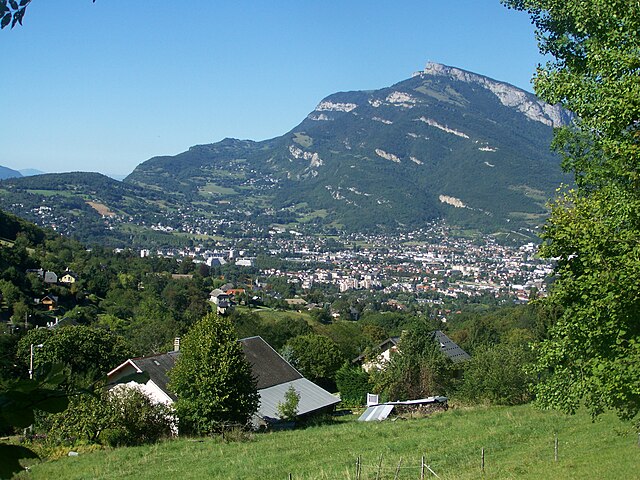
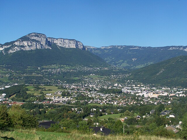
The Canton of La Ravoire is a beautiful region in the Savoie department of southeastern France, known for its stunning landscapes and access to the French Alps. While La Ravoire itself is primarily a suburban area near the city of Chambéry, it serves as a great base for exploring the surrounding natural beauty.
Hiking Opportunities
-
Nearby Trails: There are numerous hiking trails accessible from La Ravoire, including routes in the Chartreuse and Bauges mountain ranges. Popular destinations include:
- La Dent du Chat: A peak that offers panoramic views of Lake Bourget and the surrounding mountains.
- The Bauges Regional Natural Park: Offers a variety of trails that cater to different skill levels, with beautiful alpine meadows and diverse wildlife.
-
Lakes and Natural Parks: The nearby Lake Bourget is perfect for a leisurely hike around its shores, where you can enjoy views of the water interspersed with charming towns and villages. The surrounding natural parks, such as the Parc Naturel Régional de la Chartreuse and Parc Naturel Régional du Massif des Bauges, provide marked trails with varying degrees of difficulty.
-
Historical and Cultural Sites: Many hiking trails in the area lead to sites of historical interest, such as old chapels, villages, and viewpoints that offer insight into the region's rich heritage.
Tips for Hiking in La Ravoire
-
Seasonal Considerations: Hiking is best from late spring to early fall (May to October) when the weather is generally mild. Winter hiking is possible but may require snow gear and an understanding of avalanche safety.
-
Maps and Guides: It's wise to have a good map or a hiking app to guide you along the trails. Many local tourist offices can provide information about trail conditions and recommendations.
-
Safety Preparations: Remember to check the weather before heading out, wear appropriate footwear, and carry enough water and snacks. Inform someone about your hike, especially if you're venturing into less populated areas.
-
Respect Nature: Stay on marked trails, pack out what you pack in, and be mindful of local wildlife and plant life.
In summary, while La Ravoire itself may not offer extensive hiking trails, its proximity to the breathtaking Savoie mountains and lakes makes it an excellent starting point for hiking adventures in the region.
- Country:

- Capital: La Ravoire
- Coordinates: 45° 32' 51" N, 5° 58' 5" E


- GPS tracks (wikiloc): [Link]
- Population: 22388
- Wikipedia en: wiki(en)
- Wikipedia: wiki(fr)
- Wikidata storage: Wikidata: Q1725642
- INSEE canton code: [7315]
Includes regions:


Saint-Baldoph
- commune in Savoie, France
Hiking in Saint-Baldoph
Saint-Baldoph is a charming village located in the Savoie region of France, nestled in the French Alps. The area is known for its beautiful natural landscapes, which offer excellent opportunities for hiking and outdoor activities. Here’s an overview of what to expect when hiking in and around Saint-Baldoph:...
- Country:
- Postal Code: 73190
- Coordinates: 45° 32' 7" N, 5° 57' 9" E
- GPS tracks (wikiloc): [Link]
- Area: 6.24 sq km
- Population: 2870
- Web site: [Link]


Challes-les-Eaux
- commune in Savoie, France
Hiking in Challes-les-Eaux
Challes-les-Eaux, located in the Auvergne-Rhône-Alpes region of southeastern France, is known for its beautiful landscapes, thermal springs, and picturesque trails. The area offers a variety of hiking opportunities for all levels of fitness and experience. Here are some highlights about hiking in Challes-les-Eaux:...
- Country:
- Postal Code: 73190
- Coordinates: 45° 32' 51" N, 5° 59' 2" E
- GPS tracks (wikiloc): [Link]
- Area: 5.65 sq km
- Population: 5346
- Web site: [Link]


Saint-Jeoire-Prieuré
- commune in Savoie, France
Hiking in Saint-Jeoire-Prieuré
Saint-Jeoire-Prieuré is a charming village located in the Auvergne-Rhône-Alpes region of France, nestled within the beautiful French Alps. The area is a wonderful destination for hiking enthusiasts, offering a mix of scenic trails, stunning landscapes, and rich natural surroundings....
- Country:
- Postal Code: 73190
- Coordinates: 45° 32' 5" N, 5° 59' 36" E
- GPS tracks (wikiloc): [Link]
- Area: 5.34 sq km
- Population: 1432
- Web site: [Link]

Barberaz
- commune in Savoie, France
Hiking in Barberaz
Barberaz, located near Chambéry in the Savoie region of France, offers a variety of hiking opportunities, especially for those who enjoy beautiful alpine scenery and local nature. Here are some highlights and tips for hiking in and around Barberaz:...
- Country:
- Postal Code: 73000
- Coordinates: 45° 33' 48" N, 5° 56' 41" E
- GPS tracks (wikiloc): [Link]
- Area: 3.79 sq km
- Population: 4640
- Web site: [Link]

La Ravoire
- commune in Savoie, France
Hiking in La Ravoire
La Ravoire, located in the Savoie department of the Auvergne-Rhône-Alpes region in southeastern France, offers a lovely setting for hiking enthusiasts. The area is characterized by its picturesque landscapes, combining rolling hills, lush forests, and stunning views of nearby mountain ranges....
- Country:
- Postal Code: 73490
- Coordinates: 45° 33' 25" N, 5° 57' 59" E
- GPS tracks (wikiloc): [Link]
- Area: 6.82 sq km
- Population: 8100
- Web site: [Link]