Barberaz (Barberaz)

- commune in Savoie, France
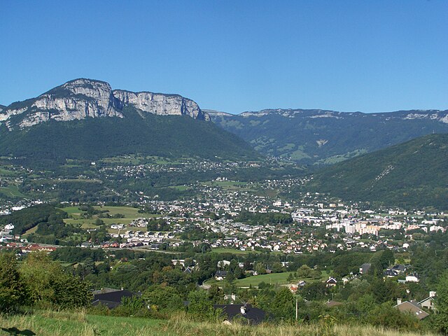
 Hiking in Barberaz
Barberaz, located near Chambéry in the Savoie region of France, offers a variety of hiking opportunities, especially for those who enjoy beautiful alpine scenery and local nature. Here are some highlights and tips for hiking in and around Barberaz:
Trail Options
-
Mount Revard: A short drive from Barberaz, Mount Revard has several hiking trails that offer stunning panoramic views of the surrounding landscapes, including Lake Bourget and the Bauges mountains.
-
Les Sentiers des Vignes: This trail leads you through vineyards and provides lovely views of the valley. It’s a great choice for a more relaxed hike, with opportunities to appreciate local flora and perhaps taste some regional wines.
-
Les Crêtes: A bit more challenging, this trail takes you along the ridges above Barberaz and provides rewarding views. It's ideal for those looking for a good workout while enjoying the natural beauty.
Hiking Tips
-
Best Time to Hike: The best seasons for hiking in Barberaz are spring and early autumn when the weather is mild, and the views are stunning. Summer can be hot, while winter may present challenges with snow and ice.
-
Trail Conditions: Always check local conditions before heading out, as some trails can be closed due to weather or maintenance. The local tourist office in Chambéry can provide updates.
-
Safety Precautions: Carry plenty of water, wear appropriate footwear, and consider trail maps or GPS for navigation as signage may not always be comprehensive.
-
Wildlife and Nature: Keep an eye out for local wildlife, such as deer and various bird species. The surrounding natural environment is also rich with diverse flora.
-
Local Amenities: After a day of hiking, you can enjoy local cuisine in Barberaz or nearby Chambéry, where you might find traditional Savoyard dishes.
Conclusion
Whether you’re a beginner or an experienced hiker, Barberaz and its surroundings offer a variety of trails that cater to all levels. Always remember to prepare adequately, respect nature, and most importantly, enjoy your hiking experience!
- Country:

- Postal Code: 73000
- Coordinates: 45° 33' 48" N, 5° 56' 41" E


- GPS tracks (wikiloc): [Link]
- Area: 3.79 sq km
- Population: 4640
- Web site: http://www.barberaz.net
- Wikipedia en: wiki(en)
- Wikipedia: wiki(fr)
- Wikidata storage: Wikidata: Q750765
- Wikipedia Commons Category: [Link]
- Freebase ID: [/m/03npg21]
- GeoNames ID: Alt: [3035033]
- SIREN number: [217300292]
- BnF ID: [15273965f]
- PACTOLS thesaurus ID: [pcrtvhUsP96e9z]
- WOEID: [12656226]
- INSEE municipality code: 73029
Shares border with regions:


Saint-Baldoph
- commune in Savoie, France
Hiking in Saint-Baldoph
Saint-Baldoph is a charming village located in the Savoie region of France, nestled in the French Alps. The area is known for its beautiful natural landscapes, which offer excellent opportunities for hiking and outdoor activities. Here’s an overview of what to expect when hiking in and around Saint-Baldoph:...
- Country:
- Postal Code: 73190
- Coordinates: 45° 32' 7" N, 5° 57' 9" E
- GPS tracks (wikiloc): [Link]
- Area: 6.24 sq km
- Population: 2870
- Web site: [Link]


Jacob-Bellecombette
- commune in Savoie, France
Hiking in Jacob-Bellecombette
Jacob-Bellecombette is a charming commune located in the Savoie department in the Auvergne-Rhône-Alpes region of southeastern France, near the city of Chambéry. The area is surrounded by beautiful natural scenery, making it an excellent destination for hiking enthusiasts....
- Country:
- Postal Code: 73000
- Coordinates: 45° 33' 20" N, 5° 54' 49" E
- GPS tracks (wikiloc): [Link]
- Area: 2.47 sq km
- Population: 3899
- Web site: [Link]


Chambéry
- commune in Savoie, France
Hiking in Chambéry
Chambéry, located in the Auvergne-Rhône-Alpes region of France, is surrounded by stunning mountains and beautiful landscapes, making it an excellent destination for hiking enthusiasts. Here are some highlights about hiking in the area:...
- Country:
- Postal Code: 73000
- Coordinates: 45° 33' 59" N, 5° 55' 15" E
- GPS tracks (wikiloc): [Link]
- AboveSeaLevel: 270 м m
- Area: 20.99 sq km
- Population: 59697
- Web site: [Link]


Bassens
- commune in Savoie, France
Hiking in Bassens
Bassens, located in the Savoie department in the Auvergne-Rhône-Alpes region of France, is near the picturesque city of Chambéry and offers a variety of outdoor activities, including hiking. The area is characterized by its beautiful landscapes, a mix of mountains, valleys, and forests, making it an excellent destination for outdoor enthusiasts....
- Country:
- Postal Code: 73000
- Coordinates: 45° 34' 52" N, 5° 56' 27" E
- GPS tracks (wikiloc): [Link]
- Area: 3.11 sq km
- Population: 3998
- Web site: [Link]


Montagnole
- commune in Savoie, France
Hiking in Montagnole
Montagnole is a charming area located in the Savoie region of France, known for its scenic beauty and outdoor activities, especially hiking. Situated near the French Alps, it offers a variety of trails that cater to different skill levels, from easy walks suitable for families to more challenging hikes for experienced adventurers....
- Country:
- Postal Code: 73000
- Coordinates: 45° 32' 17" N, 5° 54' 31" E
- GPS tracks (wikiloc): [Link]
- Area: 11.3 sq km
- Population: 837
- Web site: [Link]

La Ravoire
- commune in Savoie, France
Hiking in La Ravoire
La Ravoire, located in the Savoie department of the Auvergne-Rhône-Alpes region in southeastern France, offers a lovely setting for hiking enthusiasts. The area is characterized by its picturesque landscapes, combining rolling hills, lush forests, and stunning views of nearby mountain ranges....
- Country:
- Postal Code: 73490
- Coordinates: 45° 33' 25" N, 5° 57' 59" E
- GPS tracks (wikiloc): [Link]
- Area: 6.82 sq km
- Population: 8100
- Web site: [Link]


Saint-Alban-Leysse
- commune in Savoie, France
Hiking in Saint-Alban-Leysse
Saint-Alban-Leysse, located in the Savoie department in the Auvergne-Rhône-Alpes region of France, offers beautiful hiking opportunities amidst stunning natural landscapes. The area is characterized by its picturesque surroundings, with the Chartreuse and Bauges mountain ranges nearby, making it a great spot for outdoor enthusiasts....
- Country:
- Postal Code: 73230
- Coordinates: 45° 34' 48" N, 5° 57' 29" E
- GPS tracks (wikiloc): [Link]
- Area: 8.4 sq km
- Population: 5687
- Web site: [Link]