canton of Nanteuil-le-Haudouin (canton de Nanteuil-le-Haudouin)

- canton of France
- Country:

- Capital: Nanteuil-le-Haudouin
- Coordinates: 49° 8' 26" N, 2° 45' 34" E


- GPS tracks (wikiloc): [Link]
- Population: 31635
- Wikipedia en: wiki(en)
- Wikipedia: wiki(fr)
- Wikidata storage: Wikidata: Q620930
- INSEE canton code: [6015]
Includes regions:


Boissy-Fresnoy
- commune in Oise, France
- Country:
- Postal Code: 60440
- Coordinates: 49° 9' 49" N, 2° 52' 14" E
- GPS tracks (wikiloc): [Link]
- Area: 15.87 sq km
- Population: 1039

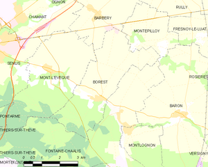
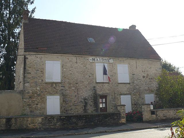
Borest
- commune in Oise, France
- Country:
- Postal Code: 60300
- Coordinates: 49° 10' 51" N, 2° 40' 14" E
- GPS tracks (wikiloc): [Link]
- Area: 12.78 sq km
- Population: 326


Silly-le-Long
- commune in Oise, France
- Country:
- Postal Code: 60330
- Coordinates: 49° 6' 25" N, 2° 47' 30" E
- GPS tracks (wikiloc): [Link]
- Area: 11.35 sq km
- Population: 1170


Rosières
- commune in Oise, France
- Country:
- Postal Code: 60440
- Coordinates: 49° 11' 18" N, 2° 46' 42" E
- GPS tracks (wikiloc): [Link]
- Area: 9.27 sq km
- Population: 136


Montagny-Sainte-Félicité
- commune in Oise, France
- Country:
- Postal Code: 60950
- Coordinates: 49° 7' 49" N, 2° 44' 18" E
- GPS tracks (wikiloc): [Link]
- AboveSeaLevel: 45 м m
- Area: 5.67 sq km
- Population: 422


Fresnoy-le-Luat
- commune in Oise, France
- Country:
- Postal Code: 60800
- Coordinates: 49° 12' 39" N, 2° 46' 7" E
- GPS tracks (wikiloc): [Link]
- Area: 11.5 sq km
- Population: 517


Lagny-le-Sec
- commune in Oise, France
- Country:
- Postal Code: 60330
- Coordinates: 49° 5' 12" N, 2° 44' 39" E
- GPS tracks (wikiloc): [Link]
- Area: 11.23 sq km
- Population: 2075


Baron
- commune in Oise, France
- Country:
- Postal Code: 60300
- Coordinates: 49° 10' 23" N, 2° 43' 46" E
- GPS tracks (wikiloc): [Link]
- Area: 21.47 sq km
- Population: 774
- Web site: [Link]

Ognes
- commune in Oise, France
- Country:
- Postal Code: 60440
- Coordinates: 49° 5' 59" N, 2° 49' 38" E
- GPS tracks (wikiloc): [Link]
- Area: 6.76 sq km
- Population: 290


Péroy-les-Gombries
- commune in Oise, France
- Country:
- Postal Code: 60440
- Coordinates: 49° 9' 45" N, 2° 50' 46" E
- GPS tracks (wikiloc): [Link]
- Area: 11.21 sq km
- Population: 1071
- Web site: [Link]

Montlognon
- commune in Oise, France
- Country:
- Postal Code: 60300
- Coordinates: 49° 9' 52" N, 2° 41' 35" E
- GPS tracks (wikiloc): [Link]
- Area: 5.24 sq km
- Population: 191
- Web site: [Link]


Ève
- commune in Oise, France
- Country:
- Postal Code: 60330
- Coordinates: 49° 5' 22" N, 2° 42' 15" E
- GPS tracks (wikiloc): [Link]
- Area: 10.43 sq km
- Population: 424


Ermenonville
- commune in Oise, France
- Country:
- Postal Code: 60950
- Coordinates: 49° 7' 34" N, 2° 41' 45" E
- GPS tracks (wikiloc): [Link]
- AboveSeaLevel: 92 м m
- Area: 16.49 sq km
- Population: 1014
- Web site: [Link]


Le Plessis-Belleville
- commune in Oise, France
- Country:
- Postal Code: 60330
- Coordinates: 49° 5' 48" N, 2° 45' 11" E
- GPS tracks (wikiloc): [Link]
- Area: 6.86 sq km
- Population: 3200


Versigny
- commune in Oise, France
- Country:
- Postal Code: 60440
- Coordinates: 49° 9' 38" N, 2° 45' 48" E
- GPS tracks (wikiloc): [Link]
- AboveSeaLevel: 70 м m
- Area: 14.5 sq km
- Population: 378


Chèvreville
- commune in Oise, France
- Country:
- Postal Code: 60440
- Coordinates: 49° 6' 36" N, 2° 50' 58" E
- GPS tracks (wikiloc): [Link]
- Area: 10.34 sq km
- Population: 438


Ver-sur-Launette
- commune in Oise, France
- Country:
- Postal Code: 60950
- Coordinates: 49° 6' 18" N, 2° 41' 7" E
- GPS tracks (wikiloc): [Link]
- Area: 13.18 sq km
- Population: 1179


Nanteuil-le-Haudouin
- commune in Oise, France
- Country:
- Postal Code: 60440
- Coordinates: 49° 8' 30" N, 2° 48' 38" E
- GPS tracks (wikiloc): [Link]
- Area: 20.95 sq km
- Population: 4093
- Web site: [Link]

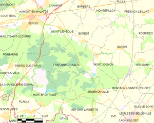
Fontaine-Chaalis
- commune in Oise, France
- Country:
- Postal Code: 60300
- Coordinates: 49° 10' 17" N, 2° 41' 1" E
- GPS tracks (wikiloc): [Link]
- Area: 33.11 sq km
- Population: 357