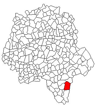
canton of Preuilly-sur-Claise (canton de Preuilly-sur-Claise)
- canton of France (until March 2015)
- Country:

- Capital: Preuilly-sur-Claise
- Coordinates: 46° 51' 20" N, 0° 55' 46" E


- GPS tracks (wikiloc): [Link]
- Wikipedia en: wiki(en)
- Wikipedia: wiki(fr)
- Wikidata storage: Wikidata: Q1189441
- Freebase ID: [/m/064qg3q]
- INSEE canton code: [3718]
Includes regions:

Charnizay
- commune in Indre-et-Loire, France
- Country:
- Postal Code: 37290
- Coordinates: 46° 54' 49" N, 0° 59' 10" E
- GPS tracks (wikiloc): [Link]
- Area: 51.71 sq km
- Population: 509


Chaumussay
- commune in Indre-et-Loire, France
- Country:
- Postal Code: 37350
- Coordinates: 46° 52' 15" N, 0° 51' 43" E
- GPS tracks (wikiloc): [Link]
- Area: 19.15 sq km
- Population: 230
- Web site: [Link]


Boussay
- commune in Indre-et-Loire, France
- Country:
- Postal Code: 37290
- Coordinates: 46° 50' 31" N, 0° 53' 18" E
- GPS tracks (wikiloc): [Link]
- Area: 27.54 sq km
- Population: 250


Chambon
- commune in Indre-et-Loire, France
- Country:
- Postal Code: 37290
- Coordinates: 46° 50' 34" N, 0° 48' 44" E
- GPS tracks (wikiloc): [Link]
- Area: 17.88 sq km
- Population: 322


Tournon-Saint-Pierre
- commune in Indre-et-Loire, France
- Country:
- Postal Code: 37290
- Coordinates: 46° 44' 21" N, 0° 57' 14" E
- GPS tracks (wikiloc): [Link]
- Area: 14.76 sq km
- Population: 451

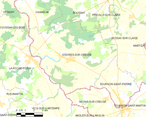
Yzeures-sur-Creuse
- commune in Indre-et-Loire, France
- Country:
- Postal Code: 37290
- Coordinates: 46° 47' 8" N, 0° 52' 14" E
- GPS tracks (wikiloc): [Link]
- AboveSeaLevel: 84 м m
- Area: 55.42 sq km
- Population: 1421
- Web site: [Link]


Preuilly-sur-Claise
- commune in Indre-et-Loire, France
- Country:
- Postal Code: 37290
- Coordinates: 46° 51' 17" N, 0° 55' 42" E
- GPS tracks (wikiloc): [Link]
- Area: 12 sq km
- Population: 1009
- Web site: [Link]


Bossay-sur-Claise
- commune in Indre-et-Loire, France
- Country:
- Postal Code: 37290
- Coordinates: 46° 49' 56" N, 0° 57' 44" E
- GPS tracks (wikiloc): [Link]
- Area: 65.56 sq km
- Population: 769
- Web site: [Link]