Charnizay (Charnizay)

- commune in Indre-et-Loire, France
- Country:

- Postal Code: 37290
- Coordinates: 46° 54' 49" N, 0° 59' 10" E


- GPS tracks (wikiloc): [Link]
- Area: 51.71 sq km
- Population: 509
- Wikipedia en: wiki(en)
- Wikipedia: wiki(fr)
- Wikidata storage: Wikidata: Q1135780
- Wikipedia Commons Category: [Link]
- Freebase ID: [/m/03nvdd4]
- GeoNames ID: Alt: [3026528]
- SIREN number: [213700610]
- BnF ID: [15257612k]
- INSEE municipality code: 37061
Shares border with regions:

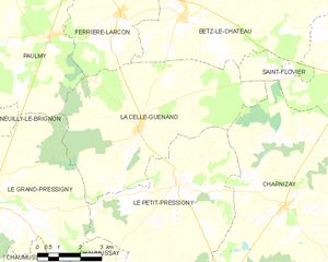
La Celle-Guenand
- commune in Indre-et-Loire, France
- Country:
- Postal Code: 37350
- Coordinates: 46° 56' 38" N, 0° 53' 38" E
- GPS tracks (wikiloc): [Link]
- Area: 36.7 sq km
- Population: 375
- Web site: [Link]
Obterre
- commune in Indre, France
- Country:
- Postal Code: 36290
- Coordinates: 46° 54' 54" N, 1° 2' 13" E
- GPS tracks (wikiloc): [Link]
- AboveSeaLevel: 121.0 м m
- Area: 28.47 sq km
- Population: 214

Le Petit-Pressigny
- commune in Indre-et-Loire, France
- Country:
- Postal Code: 37350
- Coordinates: 46° 55' 19" N, 0° 55' 9" E
- GPS tracks (wikiloc): [Link]
- Area: 32.05 sq km
- Population: 332
- Web site: [Link]


Saint-Flovier
- commune in Indre-et-Loire, France
- Country:
- Postal Code: 37600
- Coordinates: 46° 58' 5" N, 1° 1' 39" E
- GPS tracks (wikiloc): [Link]
- Area: 29.22 sq km
- Population: 577


Preuilly-sur-Claise
- commune in Indre-et-Loire, France
- Country:
- Postal Code: 37290
- Coordinates: 46° 51' 17" N, 0° 55' 42" E
- GPS tracks (wikiloc): [Link]
- Area: 12 sq km
- Population: 1009
- Web site: [Link]


Bossay-sur-Claise
- commune in Indre-et-Loire, France
- Country:
- Postal Code: 37290
- Coordinates: 46° 49' 56" N, 0° 57' 44" E
- GPS tracks (wikiloc): [Link]
- Area: 65.56 sq km
- Population: 769
- Web site: [Link]