canton of Saulzais-le-Potier (canton de Saulzais-le-Potier)
- canton of France
- Country:

- Capital: Saulzais-le-Potier
- Coordinates: 46° 35' 59" N, 2° 29' 48" E


- GPS tracks (wikiloc): [Link]
- Wikipedia en: wiki(en)
- Wikipedia: wiki(fr)
- Wikidata storage: Wikidata: Q1700881
- Freebase ID: [/m/05s_5n7]
- INSEE canton code: [1827]
Includes regions:


Saulzais-le-Potier
- commune in Cher, France
- Country:
- Postal Code: 18360
- Coordinates: 46° 35' 56" N, 2° 29' 45" E
- GPS tracks (wikiloc): [Link]
- Area: 32.38 sq km
- Population: 502
- Web site: [Link]

La Celette
- commune in Cher, France
- Country:
- Postal Code: 18360
- Coordinates: 46° 39' 5" N, 2° 31' 16" E
- GPS tracks (wikiloc): [Link]
- Area: 24.81 sq km
- Population: 176


Saint-Georges-de-Poisieux
- commune in Cher, France
- Country:
- Postal Code: 18200
- Coordinates: 46° 40' 43" N, 2° 29' 31" E
- GPS tracks (wikiloc): [Link]
- Area: 15.61 sq km
- Population: 455


Loye-sur-Arnon
- commune in Cher, France
- Country:
- Postal Code: 18170
- Coordinates: 46° 39' 10" N, 2° 23' 11" E
- GPS tracks (wikiloc): [Link]
- Area: 34.15 sq km
- Population: 312


Ainay-le-Vieil
- commune in Cher, France
- Country:
- Postal Code: 18200
- Coordinates: 46° 40' 1" N, 2° 33' 7" E
- GPS tracks (wikiloc): [Link]
- Area: 13.77 sq km
- Population: 187

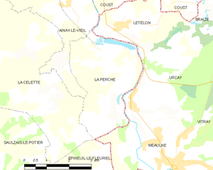
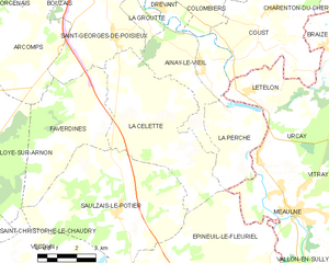
La Perche
- commune in Cher, France
- Country:
- Postal Code: 18200
- Coordinates: 46° 38' 41" N, 2° 34' 25" E
- GPS tracks (wikiloc): [Link]
- Area: 10.45 sq km
- Population: 214

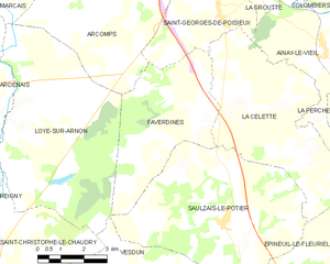
Faverdines
- commune in Cher, France
- Country:
- Postal Code: 18360
- Coordinates: 46° 38' 19" N, 2° 28' 34" E
- GPS tracks (wikiloc): [Link]
- Area: 18.51 sq km
- Population: 147

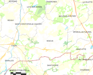
Vesdun
- commune in Cher, France
- Country:
- Postal Code: 18360
- Coordinates: 46° 32' 20" N, 2° 25' 46" E
- GPS tracks (wikiloc): [Link]
- Area: 48.61 sq km
- Population: 586

Arcomps
- commune in Cher, France
- Country:
- Postal Code: 18200
- Coordinates: 46° 40' 32" N, 2° 25' 58" E
- GPS tracks (wikiloc): [Link]
- Area: 20.14 sq km
- Population: 312


Épineuil-le-Fleuriel
- commune in Cher, France
- Country:
- Postal Code: 18360
- Coordinates: 46° 33' 32" N, 2° 35' 1" E
- GPS tracks (wikiloc): [Link]
- Area: 41.6 sq km
- Population: 459


Saint-Vitte
- commune in Cher, France
- Country:
- Postal Code: 18360
- Coordinates: 46° 32' 49" N, 2° 32' 3" E
- GPS tracks (wikiloc): [Link]
- Area: 16.38 sq km
- Population: 134